Entry No. 36 — the Pueblo file — filed under: ghost-town
Phantom Canyon Road
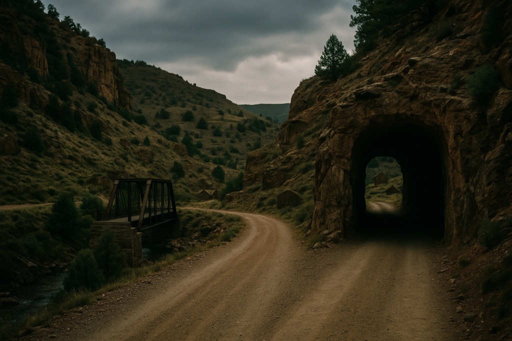
The road doesn't pave over history here — it is the history. Thirty miles of gravel trace the exact grade where the Florence & Cripple Creek narrow-gauge ran gold ore out of the mountains starting in 1894, until a flash flood on July 30, 1895 tore out miles of track and killed three people at the ghost town of Adelaide. You'll thread one-lane stone tunnels the railroad crews hand-cut, cross a steel bridge built in 1897 that's the only original F&CC span still standing, and pass the cellar-hole silhouette of Wilbur — a town of fifteen families that had a schoolhouse and then didn't have anything. The canyon got its name from something people saw out here; locals disagree on the specifics, which is exactly the kind of answer a place like this deserves.
→ Three more abandoned & forgotten places in Pueblo — never the same twice
The story
In 1894, railroad crews carved a narrow-gauge track through this sheer granite notch to haul gold ore out of the Cripple Creek mining district down to the smelters in Florence. Just one year later, on July 30, 1895, a flash flood ripped down the gorge, tore out miles of Florence & Cripple Creek track, and killed three people at the mining camp of Adelaide. The railroad patched itself back together, but the iron was eventually stripped, leaving behind a thirty-mile dirt shelf carved into the bedrock.
What remains is a gravel timeline cut into the rock. You thread narrow, hand-carved stone tunnels where the drill marks of 1890s blasters are still visible, and cross an arched steel bridge built in 1897—the only original F&CC bridge still standing over the ravine. Along the way, towns like Wilbur—where fifteen families once ran a schoolhouse before the gold dried up and the buildings collapsed—have faded into cellar holes and fence posts.
As for the name, ask three locals and you will get three different answers. Some point to early specters spotted along the tracks, others to an unexplainable light seen drifting through the canyon walls after midnight. You didn't hear it from us, but driving thirty miles of unpaved shelf road with no cell signal and sheer drop-offs makes it very easy to start seeing things in the shadows.
What it's like
You start south in Florence at 5,500 feet and crawl up to 9,500 feet near Victor over 30 miles of loose gravel and washboards. Expect blind corners, single-lane tunnels, wooden-deck bridges, and steep drop-offs without guardrails. Standard passenger cars can manage in dry weather if you take it slow, but leave the RV at home—vehicles over 25 feet are legally prohibited. Give yourself at least two hours, check Fremont County road reports before setting out (rain and structural repairs close the road regularly), and fill your gas tank first. There are zero services between towns.
The move: Drive the full 30 miles south-to-north from Florence to Victor in a single morning — stop at the 1897 steel bridge, poke around the Adelaide and Wilbur ghost town sites, and come out in Victor with grit in your teeth and a story.
📍 Before you go Unpaved gravel road, climbs from 5,500 to 9,500 ft over ~30 miles. Vehicles over 25 feet (including trailers) are prohibited. Some sections are single-lane with two-way traffic and sheer drop-offs; allow 2 hours minimum. Road can close without notice for bridge work or weather — check Fremont County road conditions before driving. No services between Florence and Victor.
- 📍 Florence
- 💸 Free
- ⚡ Up for anything
- 🌗 Outdoors
Hours: Added 2026-06-21 — confirm current hours before you go.
⚠ Seasonal or scheduled — always check before you go.
Pair it with
- Stratton's Independence Mine and Mill — Follow the original gold ore pipeline to its destination by ending your Phantom Canyon drive right at Stratton's historic mine in Victor.
- Skyline Drive — Swap one cliffside unpaved rail grade for a razorback ridge road built by prison labor just west in Cañon City.
- Desert Reef Hot Springs — Wash 30 miles of unpaved canyon dust off your windshield and skin in a private geothermal pool back down in Florence.
More weird in Pueblo

Good to know
Can I drive Phantom Canyon Road in a normal car?
Yes, in dry conditions a two-wheel-drive passenger car can handle the unpaved gravel road, though you'll need to go slow over washboards and ruts. Low-clearance vehicles should exercise caution.
Are RVs or trailers allowed on the road?
No. Vehicles over 25 feet in length, including trailers and RVs, are strictly prohibited due to tight turns and narrow single-lane tunnels.
Are there gas stations or restrooms along the route?
None. The 30-mile stretch between Florence and Victor has no fuel, cell service, water, or commercial services, so prep your vehicle before leaving Florence.
How long does the drive take?
Plan for a minimum of 2 hours for the drive itself, though stopping at the 1897 steel bridge, ghost town sites, and hand-cut tunnels will push it closer to 3 hours.
Plan a visit & invite your people →
Further reading: goldbeltbyway.com · visitcos.com · dangerousroads.org · fremontcountyco.gov · on-walkabout.net
last checked: 2026-06-21