Entry No. 22 — the Pueblo file — filed under: outdoor
Skyline Drive
“A grad student only noticed the dinosaur footprints in 1999.”
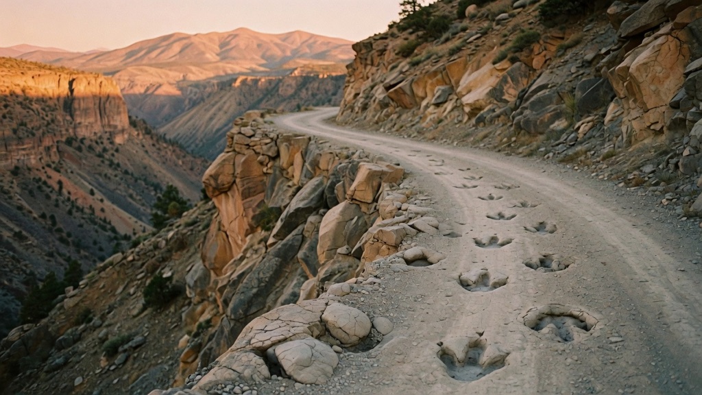
Sixty prisoners from the Territorial Prison carved this one-lane road along a razorback hogback in 1905, earning ten days off their sentences for every thirty worked. It is still one way, no guardrails, 800 feet of air on both sides. Half a mile in, the rock beside your window erupts in bumps: some fifty Cretaceous ankylosaur footprints that bulge out instead of in — you are seeing the underside of the trackway, mud casts turned to stone and tilted skyward. A grad student only noticed them in 1999.
→ Three more weird outdoor & roadside oddities in Pueblo — never the same twice
The story
In 1905, sixty male inmates from the nearby Territorial Penitentiary were offered a deal: ten days shaved off their sentence for every thirty days spent swinging pickaxes into a razorback hogback ridge. Working by hand, they carved a 2.8-mile single-lane shelf road along the absolute crest of the ridge, leaving 800 feet of sheer drop on either side. There were no guardrails installed in 1905, and none have been added since.
For ninety-four years, tens of thousands of drivers crested the ridge white-knuckling the steering wheel, completely unaware that the rock cliff inches from their side window was holding a secret. In 1999, a geology student took a close look at the stone face roughly half a mile past the entrance and noticed something strange: about fifty distinct bumps protruding outward from the cliff face. They were Cretaceous ankylosaur footprints, pressed into tidal mud over 100 million years ago and turned upside down when tectonic forces tilted the entire rock layer skyward, leaving driver-level mud casts of armored dinosaur feet.
What it's like
Passing beneath the stone arch off US-50 on the west edge of Cañon City feels like entering a chute with no exit option. Once your tires cross the threshold, you are locked into a narrow, one-way eastbound strip that rides the knife-edge crest of the hogback. The road rolls over steep, roller-coaster dips with narrow shoulders and 800-foot drop-offs on both sides. When you reach the dinosaur track sign, resist the urge to stop in the single lane; instead, park at the paved overlook roughly a hundred yards farther down, walk back along the ridge on foot, and put your hands on the inverted trackway before letting the road dump you onto 5th Street in downtown Cañon City.
The move: Park at the overlook just past the dinosaur-track sign, walk back along the ridge together, and put your hand where an armored dinosaur stepped in Cretaceous tidal mud — then ride the roller-coaster dips down into town.
📍 Before you go The entrance is a stone arch off US-50 on the west edge of Cañon City, about nine miles east of the Royal Gorge — traffic runs one-way eastbound, so once you pass under the arch you are committed until the road drops you onto 5th Street downtown. Leave trailers and wide RVs behind; the lane is barely a car wide, with steep dips and no guardrails. Do not stop at the tracks themselves — park at the overlook roughly a hundred yards farther along and walk back. Skip it on icy days, and pair it with the Museum of Colorado Prisons at the bottom of the hill.
- 📍 Cañon City
- 💸 Free
- ⚡ Up for anything
- 🌗 Outdoors
Where: 50389 W US Hwy 50, Cañon City, CO 81212 (arch entrance off US-50, west edge of town)
Hours: Added 2026-06-11 — confirm current hours before you go.
Pair it with
- Museum of Colorado Prisons — The inmate labor that hand-carved Skyline Drive in 1905 came straight from the cellhouses you can tour at the base of the ridge.
- Owl Cigar Store — Once you descend into town, head to this 1903 spot that was already operating two years before prisoners broke ground on the ridge drive above.
- Phantom Canyon Road — If unshielded cliffside shelf roads are your speed, head eleven miles east to trace this unpaved 1890s narrow-gauge railroad canyon.
More weird in Pueblo

Good to know
Can I turn around if I get nervous on the ridge?
No. Skyline Drive is strictly one-way running eastbound. Once you pass beneath the stone entrance arch off US-50, you are committed for the entire 2.8 miles until the road drops you into downtown.
Why do the dinosaur footprints stick out instead of sinking into the rock?
You are looking at the bottom side of the trackway. Armored ankylosaurs stepped in soft mud, sediment filled the depressions, and when mountain-building forces tilted the rock face almost vertical, the hardened mud casts were left bulging outward toward the road.
Can I drive an RV or pull a camper across Skyline Drive?
No. The lane is barely a car wide, features steep crests and dips, and has zero guardrails protecting against 800-foot drops. Trailers, wide trucks, and RVs are prohibited.
Where do I park to inspect the dinosaur tracks?
Do not stop directly next to the rock face in the traffic lane. Drive roughly 100 yards past the dinosaur track sign to the designated overlook turnout, park safely, and walk back along the ridge edge.
Plan a visit & invite your people →
Further reading: Wikipedia · Roadside America · canoncitycolorado.com · legendsofamerica.com · denvergazette.com
last checked: 2026-06-11