Entry No. 2 — the Salt Lake City file — filed under: land art
Spiral Jetty
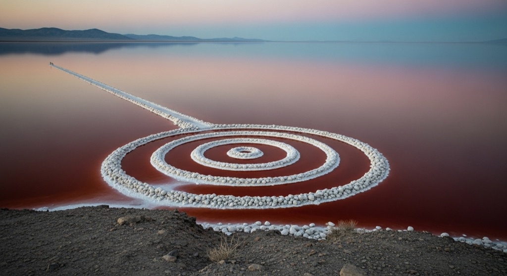
In 1970 Robert Smithson bulldozed 6,500 tons of black basalt into a 1,500-foot counterclockwise coil jutting into the lake, then it sat submerged and invisible for over two decades before drought re-exposed it — today it appears salt-crusted white or half a mile from shore depending entirely on how full the Great Salt Lake happens to be that month.
→ Three more weird outdoor & roadside oddities in Salt Lake City — never the same twice
The story
In April 1970, artist Robert Smithson rented a bulldozer, hired local contractor Bob Phillips, and spent three weeks moving 6,500 tons of dark basalt boulders and soil into the north arm of the Great Salt Lake. He picked Rozel Point specifically for its industrial scars and weird chemistry: a 1959 railroad causeway had severed the north arm from fresh water rivers, turning the isolated water into an ultra-saline brine where salt-loving algae and bacteria turn the lake blood-red.
Smithson arranged the rock into a 1,500-foot counterclockwise coil that projected out into the crimson water, but the lake swallowed his work almost immediately. Rising water levels submerged the jetty in 1972, hiding it under up to 16 feet of water for over two decades. It lived mostly as a ghost in art history textbooks until megadroughts in the early 2000s pulled the lake back and exposed the spiral once again.
What re-emerged wasn't the stark black rock Smithson laid down, but a heavily altered creature. Decades under the hypersaline water crusted every stone in thick, brilliant white salt crystals. Depending on recent rainfall and snowmelt, you might step onto a dry, crunchy salt bed to walk the coil, or find the stones half-flooded under pink foam.
What it's like
The journey out requires rattling over more than 20 miles of severe washboard gravel off Highway 83 past Golden Spike, where low-clearance tires go to die and cell signal vanishes completely. Park in the dirt lot at Rozel Point and scramble up the rocky hill first to get the aerial view of the geometry before walking down. Down on the lakebed, the mud smells sharply of decaying organic matter, and if you trek into the water, sharp salt crystals will cake onto your boots and skin like armor—pack a few gallons of tap water in your trunk just to wash off before driving back.
The move: Drive the roughly 23 miles of washboard gravel with a full tank, spare tire, and water, climb Rozel Point's hill for the aerial view of the spiral, then time it near sunset when the hypersaline water turns red from brine shrimp and algae.
- 📍 Rozel Point, Box Elder County (Great Salt Lake)
- 💸 Free
- ⚡ Up for anything
- 🌗 Outdoors
Where: Rozel Point, off Highway 83 near Golden Spike National Historical Park, Box Elder County, UT
Hours: Added 2026-07-20 — confirm current hours before you go.
⚠ Seasonal or scheduled — always check before you go.
Pair it with
- Sun Tunnels — Make it a full Land Art pilgrimage by heading west to Nancy Holt's concrete desert solstice installation.
- Dry Lake Antimony Mine — Pairs well if you want to contrast Smithson's deliberate earthwork with genuine late-19th-century mining ruins cut into the mountainside.
- Union Station (Ogden) — A natural stop in Ogden to trace the railroad infrastructure that directly caused the hyper-saline pink water at Rozel Point.
More weird in Salt Lake City


Good to know
Is there an admission fee or set hours to visit Spiral Jetty?
No. Spiral Jetty is located on public state-owned lakebed managed in partnership with Dia Art Foundation and the Utah Museum of Fine Arts. It is free to visit 24/7, though visiting during daylight hours is strongly recommended.
Are there restrooms or water at the site?
No. Rozel Point has zero facilities, shade, trash cans, or running water. The closest public restrooms are at the Golden Spike National Historical Park visitor center, roughly 16 miles back up the dirt road.
Why is the water around Spiral Jetty bright pink?
The 1959 Southern Pacific Railroad causeway cut off the lake's north arm from freshwater inflows, creating extreme salinity. Microorganisms like Dunaliella salina algae and halophilic archaea thrive in this hyper-salty environment and produce red pigments.
Will my cell phone work out there?
Cell coverage is extremely spotty to nonexistent once you turn off the paved highway. Download offline maps for Box Elder County before leaving Corinne.
Plan a visit & invite your people →
Further reading: visitutah.com · Wikipedia · umfa.utah.edu · diaart.org
last checked: 2026-07-20