Entry No. 48 — the Salt Lake City file — filed under: history
Dry Lake Antimony Mine
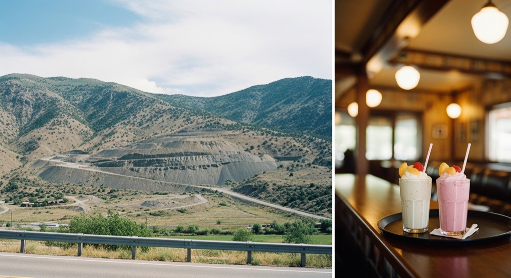
The Dry Lake Antimony Mine is an inactive late-19th-century mine located in Antimony Canyon on the steep western face of the Wellsville Mountains. It served as a primary producer of antimony and silver, with its most significant production occurring between 1908 and 1917, followed by a brief revival during World War II. Today, the mine is completely abandoned, leaving behind a prominent scar from its old access road carved into the foothills along with scattered tailings.
→ Three more abandoned & forgotten places in Salt Lake City — never the same twice
The story
Most people heading north on Highway 38 are watching for fruit stands or the turnoff to Calls Fort, completely missing the industrial scar gouged high into the western wall of the Wellsville Mountains. Turn-of-the-century prospectors didn't crawl up the sheer face of Antimony Canyon looking for glittering gold—they were after antimony, a brittle, toxic metalloid critical for toughening lead alloys and making explosives, along with secondary veins of silver. Also recorded on historic geological maps as the Copper Blossom Mine, the high-altitude site saw its furious peak between 1908 and 1917.
When international trade opened up after WWI, the economics collapsed and the site was abandoned to the elements, save for a brief, frantic re-opening during World War II when the military rushed to secure domestic critical mineral stockpiles. Since then, nobody has bothered to tidy up. What remains up there isn't a polished heritage park or a preserved wooden town—it is a raw, jagged slice cut into the mountainside where an old access road once defied gravity, surrounded by pale heaps of mine tailings sloughing off into the scrub.
What it's like
Do not attempt to hike up and scramble into the workings unless you enjoy loose shale slide-offs and plunging down unmapped, unsecured vertical shafts. The smart move is to pull off Highway 38 north of Brigham City, cut the engine, and scan the steep face of the Wellsvilles through binoculars to trace the zig-zag path of the access road cut into the dirt. Follow up the distant ruin-gazing with a low-altitude stop at the 1930s Peach City car hop down the road for a fresh peach shake.
The move: Take a scenic drive along Highway 38 north of Brigham City to view the historic mine scar on the mountainside, then stop by the nearby 1930s-era Peach City car hop for a classic peach shake.
📍 Before you go The mine workings are located on steep, rugged terrain with hazardous, unsecured shafts, but the historic site and its access road scar are clearly visible from public vantage points along Highway 38.
- 📍 Brigham City
- 💸 Free
- ⚡ Low-key
- 🌗 Outdoors
Where: 2935-2743 N Hwy 38, Brigham City, UT 84302, USA
Hours: Added 2026-07-20 — confirm current access before you go.
Pair it with
- Spiral Jetty — Swap an accidental, abandoned industrial scar on the Wellsville slopes for Robert Smithson's intentional 1970 basalt earthwork farther west in Box Elder County.
- Union Station (Ogden) — Pair a remote, scraped-out mountain mine with Ogden's grand 1920s rail depot and subterranean pedestrian subway down south.
- Limekiln Gulch Pioneer Kilns — If you are mapping out Utah's forgotten pioneer extractions, follow up the antimony scar with these mid-19th-century stone lime kilns hidden in the Salt Lake foothills.
More weird in Salt Lake City
Good to know
Can I hike up and go inside the mine shafts?
It is strongly advised against. The terrain on the steep western face of the Wellsville Mountains is rugged, unstable, and filled with hazardous, unsecured open shafts. The best and safest view is from public vantage points down along Highway 38.
What exactly was mined at Dry Lake?
It was primarily a producer of antimony—a heavy mineral used in metallurgy and munitions—along with silver, lead, and copper.
Why is it also called the Copper Blossom Mine?
Early Utah mining records and state geological survey maps frequently refer to the Dry Lake workings near the mouth of Antimony Canyon as the Copper Blossom Mine.
When was the mine active?
Its heaviest production ran from 1908 through 1917, followed by a short-lived surge during World War II before permanent abandonment.
Plan a visit & invite your people →
Further reading: vertexaisearch.cloud.google.com · thediggings.com · ugspub.nr.utah.gov
last checked: 2026-07-20