Entry No. 7 — the Grand Junction file — filed under: roadside-oddity
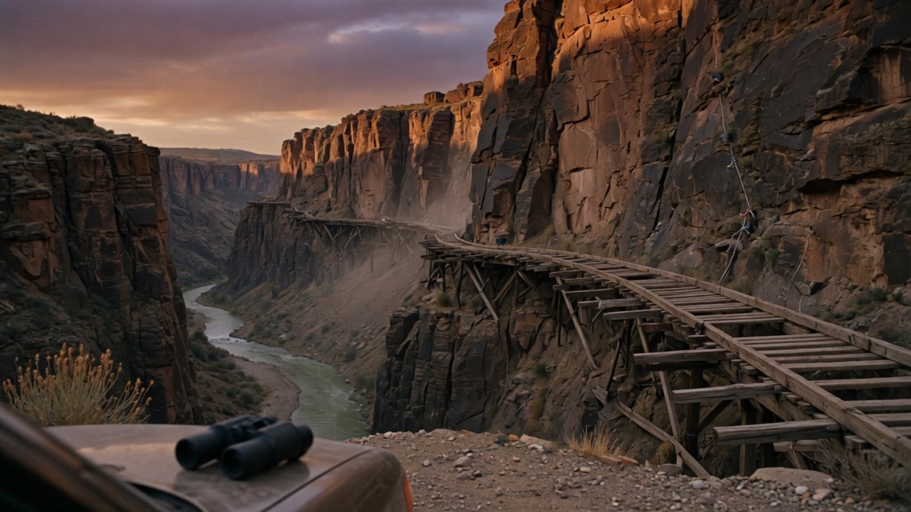
Hanging Flume Overlook
“The flume is still up there 130-odd years later.”
In the late 1880s, St. Louis investors paid crews to dangle from ropes off a sheer Dolores Canyon wall and bolt a wooden water chute to the rock — ten-plus miles of it, up to 75 feet above the river, moving 80 million gallons a day toward a hydraulic gold claim. The gold barely existed: three years and a million dollars in, roughly $80,000 came out, and everyone walked away. The flume is still up there 130-odd years later, visible from a signed pulloff on CO-141.
→ Three more weird outdoor & roadside oddities in Grand Junction — never the same twice
The story
In the late 1880s, moneyed speculators from St. Louis decided the path to fortune in remote western Colorado required hanging ten miles of wooden trough off a sheer cliff face. The Montrose Placer Mining Company burned through roughly $1,000,000—a fortune at the time—to route 80 million gallons of water a day to their hydraulic gold claims downstream. To build it, workmen were lowered over the rim of the canyon on ropes, dangling up to 75 feet above the Dolores River to hand-drill holes into red sandstone, drive iron brackets, and bolt down Douglas fir planking.
The engineering was a triumph, but the geology was a disaster. After three years of blasting gravel beds with high-pressure water, the operation recovered roughly $80,000 in fine gold. The company abandoned the project and walked away, leaving miles of timber pinned to cliffs where no sane builder had any business standing. Thanks to the desert air, long runs of that wooden skeleton still cling to the rock face more than 130 years later.
What it's like
Pull off CO-141 into the signed gravel turnout along the river canyon. Bring binoculars—from the viewing platform, the remaining greyed timbers across the river look like matchsticks pinned to the wall, and you need magnification to appreciate the iron brackets holding them up. There are no services here, no shade, and zero cell service. Do not attempt to scramble down to the river or reach the structure; it sits on sheer, protected rock and trying to touch it is both illegal and dangerous. Fill your gas tank in Gateway or Naturita before making the drive.
The move: Pack binoculars, pull off at the signed CO-141 overlook, trace the flume line along the opposite canyon wall together, then argue over which of you would have taken the rope-dangling construction job.
📍 Before you go The signed interpretive pulloff sits on CO-141 along the Unaweep-Tabeguache Scenic Byway, roughly 29 miles southeast of Gateway and 5 miles northwest of Uravan, with parking and panels right off the highway; the best surviving run of flume hugs the canyon wall across the river, so binoculars earn their keep. Do not attempt to reach the structure itself — it is fragile, protected, and the terrain is sheer. A 40-foot section rebuilt in 2012 can be glimpsed near the Dolores-San Miguel confluence off the rough Y11 county road. There is no fuel or cell service for long stretches, so top off in Gateway or Naturita and pair the stop with the Unaweep Canyon divide on the drive down.
- 📍 Gateway
- 💸 Free
- ⚡ Up for anything
- 🌗 Outdoors
Where: Hanging Flume Overlook pulloff, CO-141, about 5 miles northwest of Uravan / 29 miles southeast of Gateway, CO 81429
Hours: Added 2026-06-11 — confirm current hours before you go.
Pair it with
- Unaweep Canyon — Drive through this unique dual-draining canyon along Highway 141 on your way down to the flume overlook.
- Calamity Camp Mining Site — Pair the flume's failed gold scheme with a visit to this radioactive mesa-top uranium camp located 15 miles north.
- Driggs Mansion Ruins — Combine one desert construction folly with another by stopping at these abandoned 1918 stone mansion ruins along the same highway route.
More weird in Grand Junction

Good to know
Where is the Hanging Flume Overlook located?
It sits directly off CO-141 (the Unaweep-Tabeguache Scenic Byway), roughly 29 miles southeast of Gateway and 5 miles northwest of the former uranium mining townsite of Uravan.
Can I hike up to the remaining flume structure?
No. The surviving original flume clings to sheer cliff faces across the Dolores River. It is extremely fragile, protected as a historic site, and physically dangerous to reach.
Is there cell service or fuel at the pullout?
No. The canyon is a complete dead zone for mobile reception, and there is no fuel for long stretches along CO-141, so top off in Gateway or Naturita beforehand.
Is there any place to see a restored piece of the flume?
Yes. A 40-foot section of the flume was reconstructed in 2012 using historical methods and can be viewed near the confluence of the Dolores and San Miguel rivers off rough County Road Y11.
Plan a visit & invite your people →
Further reading: Wikipedia · utbywayco.com · uncovercolorado.com · coloradopreservation.org
last checked: 2026-06-11