Entry No. 8 — the Grand Junction file — filed under: outdoor-weird
Little Book Cliffs Wild Horse Range
“By July the bands climb, and you earn your sightings.”
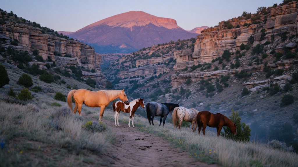
Congress set aside exactly three ranges in America specifically for wild horses, and this is the one hiding behind Mount Garfield. Roughly 36,000 acres of pinyon-juniper canyon country hold bands of palominos, paints, roans, and appaloosas — two to ten horses to a band, sometimes grazing within a mile of the Coal Canyon trailhead. Local volunteers know most of them by name. In spring, foals work the lower canyons; by July the bands climb, and you earn your sightings.
→ Three more weird outdoor & roadside oddities in Grand Junction — never the same twice
The story
In 1971, Congress passed the Wild Free-Roaming Horses and Burros Act, set aside federal land across the West, and designated exactly three areas in the entire nation specifically for the protection and preservation of wild horses. The Little Book Cliffs Wild Horse Range is the one wedged right into the sandstone canyons directly behind Mount Garfield, encompassing roughly 36,000 acres of rugged pinyon-juniper tableland.
What makes this herd distinct isn't just their isolation, but their genetics and management. Local volunteers with the non-profit Friends of the Mustangs have tracked these animals for decades, maintaining photographic census records and recognizing individual bands by name. The herd carries heritage tracing back to Spanish stock along with draft and ranch strains, resulting in striking color coats—palominos, paints, blue roans, and appaloosas—grazing in family bands of two to ten horses led by a dominant stallion.
You didn't hear it from us, but you don't need a heavy 4x4 rig or a backwoods expedition to spot them if you time it right. While the upper plateaus require brutal dirt roads out of De Beque, the lower Coal Canyon entrance sits just two miles off Interstate 70. In early spring, mares bring their newborn foals down into the low canyon bottoms right near the trailhead, letting you watch wild horse dynamics play out against red rock walls without leaving the foot trail.
What it's like
Arriving at the Coal Canyon Trailhead off I-70 feels almost too easy until you step past the pipe gate and head up the wash. The landscape is quiet, exposed, and entirely devoid of shade or water piped in for humans, so bring more liquid than you think you need. Early morning visits in April and May offer your best shot at seeing bands near the first mile of trail; by July, heat drives the herds high up onto the plateau, turning a casual walk into a steep, sun-baked hike. Keep a respectful distance—at least 100 feet—and bring binoculars or a telephoto lens, because while these horses are accustomed to seeing hikers, they remain untamed animals that will move off if crowded.
The move: Pack coffee and binoculars, hit the Coal Canyon Trailhead at first light, and hike the Main Canyon Trail until you spot a band — spring mornings they are often inside the first mile.
📍 Before you go Two ways in: the Coal Canyon Trailhead sits 2.2 miles up a well-graded gravel road off I-70 Exit 46 at Cameo and any car can make it, while the Winter Flats and Dry Fork roads out of De Beque are 20-plus miles of true 4x4 dirt that turn impassable when wet. The Coal Canyon road gate closes to vehicles December through May to protect wintering wildlife and foals, but walking in is allowed year-round. Horses move low in spring and high in midsummer, and they are most active mornings and evenings — bring water, there is none on the trail. Pair it with Palisade wineries and fruit stands ten minutes back down the interstate.
- 📍 De Beque
- 💸 Free
- ⚡ Up for anything
- 🌗 Outdoors
Where: Coal Canyon Trailhead via I-70 Exit 46 (Cameo), or Winter Flats Rd out of De Beque, CO 81630
Hours: Added 2026-06-11 — confirm current hours before you go.
Pair it with
- Palisade Insectary — After tracking wild horse bands in the canyon washes, swing down the highway to see how Colorado breeds millions of beneficial bugs to fight invasive weeds.
- Carboy Winery at Mt. Garfield Estate (Custom Blending Lab) — Trade dusty binocular scouting in the shadow of Mount Garfield for a session pouring and blending your own estate wine right at the cliff's base.
- Colterris Winery Barrel Cave — Follow up a morning on exposed desert BLM land with a underground pour inside a cool, barrel-lined cave carved straight into the Palisade hillside.
- Book Cliff Mine — If you want to stay in the Book Cliffs backcountry, pair the horse range with the nearby ruined stone foundations of the 1880s coal mining operation.
More weird in Grand Junction
Good to know
When is the road to Coal Canyon Trailhead open to vehicles?
The 2.2-mile gravel access road from Cameo (I-70 Exit 46) is closed to motorized vehicles from December 1 through May 31 to protect wintering wildlife and foals, but foot and horseback access is permitted year-round.
Do I need a 4WD vehicle to visit?
Not if you use the Coal Canyon Trailhead off I-70 Exit 46, which is accessible via a well-graded gravel road suitable for standard passenger cars. However, entering from the northern access points via Winter Flats or Dry Fork out of De Beque requires a high-clearance 4x4 and turns impassable when wet.
Are there restrooms or drinking water at the trailhead?
There is a vault toilet at the Coal Canyon Trailhead, but no potable water anywhere on the range. You must carry all the water you will need for your hike.
What time of day is best for spotting horses?
First light in the morning and late afternoon right before dusk are prime viewing windows when the bands move down to graze and seek water sources.
Plan a visit & invite your people →
Further reading: blm.gov · visitgrandjunction.com · friendsofthemustangs.org
last checked: 2026-06-11