Entry No. 161 — the Denver file — filed under: raised dino tracks
Triceratops Trail
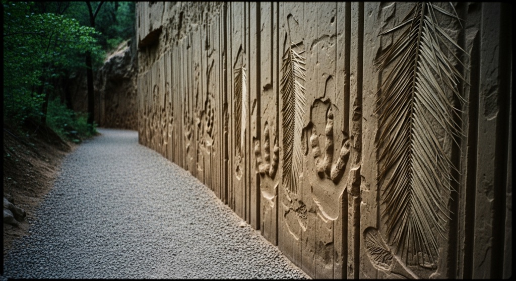
A free, 1.5-mile gravel trail through a reclaimed clay-mining canyon where 68-million-year-old Triceratops and Tyrannosaur tracks protrude outward from vertical sandstone walls as raised negative casts — the inverse of a normal footprint, as if viewed from below the mud surface — alongside fossilized palm fronds. Designated a National Natural Landmark in 2011, it's one of the only places on Earth where you can see dinosaur tracks this way.
→ Three more weird outdoor & roadside oddities in Denver — never the same twice
The story
Sixty-eight million years ago, Golden was a swampy tropical delta where Tyrannosaurs and four-toed Triceratops plodded through sticky mudflats framed by palm fronds and sycamores. When the Rocky Mountains shoved upward millions of years later, those horizontal mud beds were tilted vertically like books stacked on end. But you wouldn't be staring at their footprints today if Denver hadn't needed sewer pipes and construction bricks in 1877.
Clay miners carved deep pits along 19th Street, stripping away soft clay that ended up in the walls of the Colorado Governor's Mansion and East High School. In doing so, they exposed vertical sheets of hard sandstone that had originally capped the mud. The softer clay crumbled away, leaving behind "outies"—raised negative casts where ancient sand washed into foot impressions, preserving the three-dimensional underside of dinosaur steps bulging outward into thin air.
Designated part of a National Natural Landmark in 2011, the reclaimed quarry now sits right against the edge of the Fossil Trace Golf Course. Instead of manicured grass, you walk past raw sandstone walls displaying three-toed Tyrannosaur prints, Triceratops tracks, and massive fan-shaped palm frond impressions that prove Colorado was once prime beachfront jungle.
What it's like
You'll park in Colorado School of Mines' Jones Lot A off 19th Street—free on weekends, paid via kiosk on weekdays—and locate the trailhead tucked in the southwest corner. The flat, 1.5-mile gravel loop takes roughly an hour, winding between high sandstone walls and active fairway greens with 6th Avenue traffic buzzing in the background. The path is entirely unsheltered with zero shade, restrooms, or water, so time your visit for early morning or late afternoon when low, raking light casts the deep shadows required to make the 3D bulge of the tracks pop off the rock wall.
The move: Park free on weekends in Jones Lot A off 19th St, then walk the 1.5-mile loop together, stopping at each interpretive panel to find the "outies" — challenge each other to spot the raised three-toed Tyrannosaur print and the four-toed Triceratops tracks bulging out of the canyon walls. Bring lunch and finish with a cold beer at one of Golden's nearby breweries (Cannonball Creek or Barrels & Bottles are a short drive away).
📍 Before you go The trailhead hides at the southwest corner of Jones Lot A, a Colorado School of Mines lot one block east of 6th Avenue and 19th Street — head east on 19th and turn onto Jones. Parking is free on weekends but paid on weekdays, and only a couple of spots sit right at the trailhead; on busy days fall back to street parking on Tangent Way or the Mines Park lot, reachable via a pedestrian underpass beneath 6th Avenue. It's free, self-guided, and flat gravel — about an hour round trip — with no restrooms or shade, so bring water and sun protection. The raised "negative-cast" tracks read best in low, raking morning or late-afternoon light. For deeper context, time a visit to one of the "Walk with a Geologist" events, or pair it with sibling site Dinosaur Ridge just down the road before those Golden breweries.
- 📍 Golden
- 💸 Free
- ⚡ Up for anything
- 🌗 Outdoors
Where: Trailhead at Jones Lot A, 19th Street & Jones Road, Golden, CO 80401
Hours: Mined 2026-06-07 — confirm current hours before you go.
Pair it with
- Buffalo Rose — After inspecting 68-million-year-old mud casts, head less than a mile into historic Golden for a cold beer at Colorado's oldest continuously operating bar.
- Rock Rest Lodge — Keep the gritty local history going by pairing reclaimed clay mining pits with a former 1885 stagecoach stop that spent decades operating as a brothel and speakeasy.
- NSF Ice Core Facility — Trade Golden's sun-baked Late Cretaceous sandstone for a federal walk-in freezer holding miles of prehistoric polar ice cores.
- Mount Morrison South Ridge Trail — If an hour on a flat gravel trail leaves you restless, head south for a steep, unmaintained ridge scramble looming over Red Rocks.
More weird in Denver

Good to know
Why do the dinosaur footprints bulge outward instead of sinking in?
They are negative casts, or "outies." When dinosaurs stepped into wet Cretaceous clay, sand filled the depressions and hardened into rock over millions of years. Tectonic uplift turned the rock vertical, and 19th-century clay miners dug away the softer clay layer, exposing the raised sandstone casts sticking out from the canyon walls.
When is the best time of day to view the tracks?
Early morning or late afternoon. Because the fossil tracks are raised 3D casts on vertical stone walls, midday overhead sun washes them out, while low-angled sunlight casts long shadows that make the footprint shapes clearly visible.
Are there restrooms, shade, or drinking water along the trail?
No. The 1.5-mile gravel loop has no shade, water fountains, or bathroom facilities. Pack water, wear sun protection, and plan for an hour-long round-trip walk.
Where are the fossilized palm fronds located?
Near the eastern stretch of the trail right along hole #13 of the Fossil Trace Golf Course, where a vertical sandstone wall is covered in large, fan-like palm frond impressions.
Plan a visit & invite your people →
Further reading: dinoridge.org · visitgolden.com · nps.gov · gjhikes.com · prnewswire.com
last checked: 2026-06-07