Entry No. 176 — the Denver file — filed under: outdoor
Mount Morrison South Ridge Trail
“thousands of concertgoers stare at without ever realizing they can climb it”
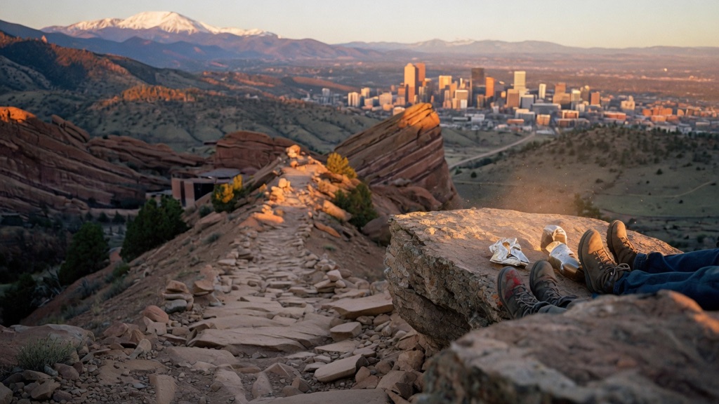
Everyone drives past this one. Mount Morrison is the jagged peak looming directly over Red Rocks Amphitheatre, but the south ridge that climbs it has no official designation, no maintained tread, and no fanfare — just an unsigned bootpath up a steep, rocky spine that thousands of concertgoers stare at without ever realizing they can climb it. It's barely two miles up but stacks 2,000 feet of gain into it, with hand-over-rock Class 2 scrambling and loose stone near the top. The reward is outsized: Red Rocks' fins in silhouette below you, the full Denver skyline to the east, and the Front Range and Mount Blue Sky stacked behind you to the west. Gritty, intimate, earned.
→ Three more weird outdoor & roadside oddities in Denver — never the same twice
The story
Millions of concertgoers stare right at Mount Morrison every season from the bleachers of Red Rocks Amphitheatre without ever realizing you can climb the damn thing. Towering 7,881 feet directly over the red sandstone monoliths, the jagged peak looks like a private backdrop reserved for stage lighting. But tucked just past the gate on Titans Road at Entrance 4, an unsigned, unmaintained bootpath climbs straight up the south ridge. There are no grand arches marking the start, no official park maps, and precisely zero switchbacks—just a gritty single-track cut straight up the fall line by decades of local legs.
The mountain has a habit of chewing up big ambitions. In the early 1900s, Denver entrepreneur John Brisben Walker built a funicular railway to carry tourists to a casino near the summit, but nature eventually reclaimed the slope, leaving only dirt, rock, and raw incline. Today, land managers tolerate the south ridge route—even installing wire gabions in recent years to slow down erosion—but they haven't cushioned the blow. You stack roughly 2,000 vertical feet of gain into under two miles, tackling a steep spine of loose gravel and hand-over-rock Class 2 scrambling.
What it's like
Parking in the small, 20-car gravel pullout off Titans Road feels like pulling over for a quick roadside break, until you look straight up at the ridge. The trail wastes no time: you start on hard-packed clay that pitches immediately skyward, forcing your quads to work before your lungs even catch up. Because the path sticks strictly to an exposed south-facing spine, there is zero shade, zero water, and no relief from the sun—or the rattlesnakes warming themselves on the lower rocks. Higher up, the trail degrades into loose scree and rocky chutes where you'll be checking your holds, calling out loose stone, and scrambling on all fours. Reaching the summit block delivers an unvarnished 360-degree panorama: Red Rocks' sandstone fins sit miniature below your boots, the Denver skyline lays out flat to the east, and Mount Blue Sky towers behind you to the west. Start before dawn to beat the heat and ensure you're off the summit before midday, when Front Range thunderstorms turn an exposed metal-and-rock ridge into a lightning rod.
The move: Skip the easy stroll and turn the climb itself into the date. Pick a clear morning, pack one water bottle each and a summit snack, and take the unmarked path slow — you'll be passing each other holds, calling out loose rock, and grabbing each other's hands on the steep bits, which does more for two people than any candlelit table. Top out, sit on the summit block with the whole Denver skyline laid out and Red Rocks tiny beneath your boots, split the snack, then pick your way back down. A shared little ordeal with a huge view at the turnaround.
📍 Before you go About 3.6 miles round trip with roughly 2,000 ft of gain — short but relentlessly steep, rated hard. This is an unofficial, unmaintained route: expect rocky single-track, route-finding on an unsigned bootpath, and a couple of short Class 2 scrambling moves with loose gravel near the summit, so wear grippy shoes with ankle support. Biggest safety note: it's an exposed, south-facing ridge with no shade and no water — start early and be off the summit before midday, when Front Range thunderstorms and lightning build fast in summer. Slippery when wet, and best done June through October when the rock is dry and snow-free; skip it after rain or with ice. Watch for rattlesnakes on warm days. It's free with no permit required; the small gravel lot fills on summer weekends, so arrive early. What you'll find: a quiet, gritty climb and one of the best Denver-skyline-plus-Red-Rocks panoramas anywhere near the city.
- 📍 Morrison / Red Rocks (west of Denver)
- 💸 Free
- ⚡ Up for anything
- 🌗 Outdoors
Where: Titans Road trailhead at Red Rocks Park Entrance 4, off State Hwy 74 (Bear Creek Ave) about 1-2 miles west of the town of Morrison. From Denver, take US-285 or C-470 to Morrison and follow Bear Creek Ave west; just past the Red Rocks gate on Titans Road there's a small gravel pullout/lot (room for ~20 cars) on the right and a "hiking only" sign on the left where the trail starts up the ridge.
Hours: Day-use, free. Best season: June through October (dry, snow-free rock). Confirm trail & road conditions before you go.
⚠ Seasonal or scheduled — always check before you go.
Pair it with
- Morrison Natural History Museum — Trade the brutal mountain climb for a small, hands-on museum down the road where staff actually discovered baby dinosaur trackways.
- Mount Falcon 'Summer White House' Ruins — Pair one steep foothills climb with another to inspect the marble cornerstone and stone foundations of an unfinished 1911 presidential retreat.
- Piggin' Out Smokehouse — Refuel after burning 2,000 vertical feet of quad-killing effort with slow-smoked brisket served from a humble red shack down Morrison Road.
More weird in Denver


Good to know
Where is the trailhead for the Mount Morrison South Ridge Trail?
The route starts off Titans Road at Red Rocks Park Entrance 4, off State Hwy 74 (Bear Creek Ave) about 1 to 2 miles west of Morrison. Park in the small gravel pullout on the right (holds about 20 cars) and cross to the 'hiking only' sign on the left where the bootpath heads up the ridge.
How long and steep is the hike?
The trail is roughly 3.6 to 3.8 miles round trip with almost 2,000 feet of elevation gain. It is rated hard because the gain is compressed into under two miles with steep grades, loose gravel, and short Class 2 scrambling moves.
Are there water sources or shade on the route?
No. The entire south ridge is fully exposed with no shade cover or water, so you must bring all the water you need and wear sun protection.
Do I need a permit or fee to hike Mount Morrison?
No. Access is free and no hiking permits or parking passes are required.
When is the best season to hike it?
June through October offers dry, snow-free conditions. Avoid the trail during or immediately after rain, snow, or ice, which makes the steep clay and loose rock treacherous.
Plan a visit & invite your people →
Further reading: 10adventures.com · hikingproject.com · Official site · 5280 · Reddit · cmc.org
last checked: 2026-06-10