Entry No. 173 — the Denver file — filed under: outdoor
Rattlesnake Gulch Trail
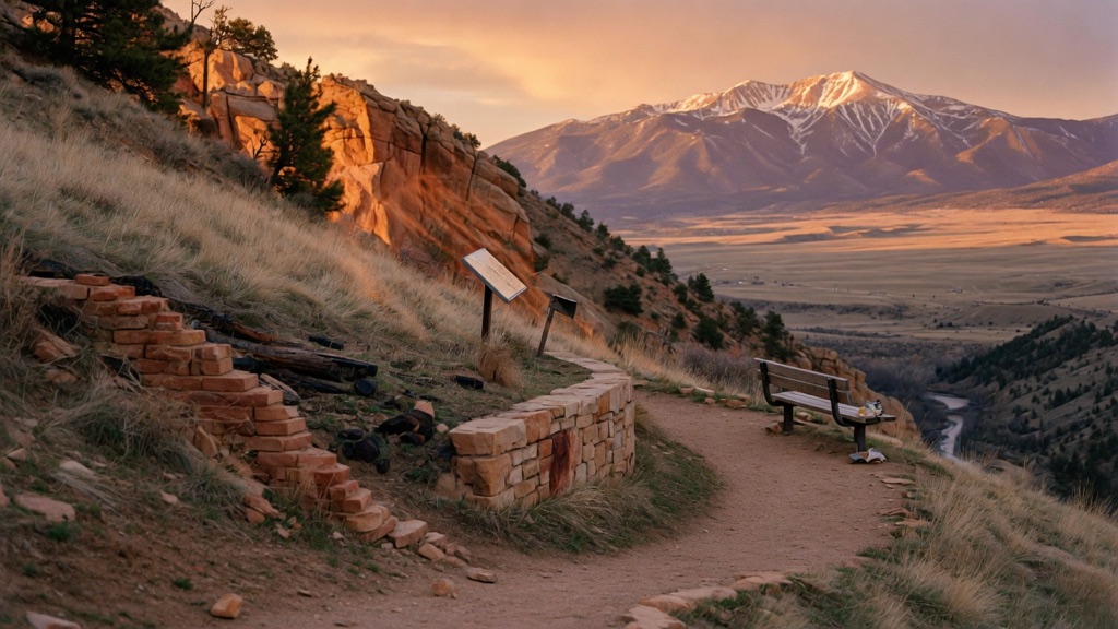
Eldorado Canyon is famous for its sandstone walls and the climbers dangling off them — so almost everyone clusters at the bottom and looks up. Cross the creek and start climbing instead, and within a mile you reach a quiet hillside scattered with brick footings and a stone retaining wall: all that's left of the Crags Hotel, a luxury resort reached by inclined railway that opened in 1908 and burned in 1912. Switchback higher and the trail delivers a Continental Divide overlook where the eastern plains spill out one way and snow-streaked peaks rise the other. Ruins, railroad-grade history, and a big-sky payoff, on a loop most canyon visitors never bother to find.
→ Three more abandoned & forgotten places in Denver — never the same twice
The story
While most visitors to Eldorado Canyon cluster at the bottom of the sheer sandstone walls watching rock climbers hang from ropes, cross South Boulder Creek and start heading uphill instead. In 1908, a luxury resort called the Crags Hotel opened on this quiet, elevated perch. Well-heeled Denver tourists reached it by three unlikely routes: a rugged wagon road up the gulch, the Moffat Road railroad winding along the cliffs above, or a water-and-gravity funicular tramway that hauled passengers straight up the mountainside. For a dollar, guests could spend a day drinking artesian spring water, dancing, and playing poker high above the canyon floor.
The resort didn't last. In November 1912, after closing for the season, the hotel burned to the ground under circumstances that remain an unsolved Front Range mystery—arson and natural fire are still debated. Today, pine trees and undergrowth have reclaimed the hillside, but if you step off the trail where it splits, the ghost of the resort is easy to trace. You'll find a circular concrete fountain basin now serving as an overgrown wild planter, mossy stone retaining walls, brick foundation scraps, and the stone remains of a kitchen fireplace where rusted metal utensils still sit exposed.
Continue past the hotel site on the upper loop to reach the Continental Divide overlook at roughly 7,200 feet. Here, the trail approaches the active tracks of the old Moffat Line—where freight trains still rumble through—before delivering a dramatic geographical contrast: behind you, the eastern plains stretch flat toward Kansas; ahead, snow-streaked peaks line the Continental Divide.
What it's like
Expect a steady, gravelly 3.8-mile lollipop loop with roughly 960 feet of elevation gain that gets your lungs working without requiring any hands-and-knees rock scrambling. You'll hike past shaded ponderosa pines, historical interpretive plaques, and open cliffs overlooking the canyon floor. The trickiest part isn't the climb—it's getting a vehicle into the park. On weekends and summer holidays between May 1 and October 1, the state park mandates a timed-entry vehicle reservation booked in advance; skip the parking gamble on those days by riding the free Eldo Shuttle out of Boulder, or arrive on a quiet weekday morning. Bring traction microspikes in early spring or late fall when ice sheets lurk in the shaded switchbacks, and start early enough in summer to clear the top before afternoon lightning storms roll over the ridge.
The move: Make the climb the date: pack water and one good snack, then hike up together past the burned-out Crags Hotel ruins, reading the interpretive signs aloud and imagining guests arriving by railcar in 1909. Keep going to the Continental Divide overlook, claim the bench, and trade which view you'd rather wake up to — plains or peaks — before looping back down through the canyon.
📍 Before you go A 3.8-mile lollipop loop with about 960 ft of gain, rated moderate — a steady grade on rocky, gravelly trail, no scrambling. The trailhead sits roughly 0.6 mi inside Eldorado Canyon State Park off Eldorado Springs Drive (Route 170); from Denver it's about 45 minutes via US-36 and Route 170 through Eldorado Springs, or about 20 minutes south of Boulder. Best from late spring through fall; the upper switchbacks and overlook hold snow and ice into spring and after storms, so bring traction in shoulder season and start early to dodge summer afternoon lightning at altitude (trail tops out around 7,200 ft). This is a fee state park requiring a valid Colorado Parks pass or daily vehicle entrance fee, and — critically — on weekends and summer holidays in the warm season the park requires a timed-entry vehicle reservation booked in advance; on those days you can instead skip the car and ride the free Eldo Shuttle from Boulder. Parking is limited and fills fast. Leashed dogs are allowed, and the lower trail is open to mountain bikes. You'll find the Crags Hotel ruins (brick foundations and stone walls), a Continental Divide overlook with benches, and views down into the canyon and out to the plains.
- 📍 Eldorado Canyon State Park (Eldorado Springs, ~20 min south of Boulder)
- 💸 Free
- ⚡ Up for anything
- 🌗 Outdoors
Where: Rattlesnake Gulch trailhead, on the south side of the road roughly 0.6 mi past the entrance station in Eldorado Canyon State Park, off Eldorado Springs Drive (Route 170), Eldorado Springs / Boulder, CO 80025. From Denver: US-36 toward Boulder, exit at McCaslin Blvd and head south/west via Marshall Rd to Route 170, then west through Eldorado Springs to the park entrance (about 45 min). From Boulder: south on Route 93, right on Route 170 and into the canyon (about 20 min).
Hours: Day-use, free. Best season: Late spring through fall (summer and fall are ideal). Confirm trail & road conditions before you go.
⚠ Seasonal or scheduled — always check before you go.
Pair it with
- Mount Falcon 'Summer White House' Ruins — Pair one turn-of-the-century mountain resort ruin with another high-altitude ruin built by a Front Range visionary.
- Castlewood Canyon Dam Ruins — Trade the burned resort ruins of Eldorado Canyon for the colossal broken concrete shell of a collapsed 1890 dam in Douglas County.
- Historic Elitch Theatre — Connect the short-lived 1908 resort culture of the Crags Hotel with a surviving 1890 historic theater in West Highland.
More weird in Denver
Good to know
How difficult is the hike to Rattlesnake Gulch?
It is rated moderate—a 3.8-mile lollipop loop with about 960 feet of gain on a rocky, steady trail with no scrambling involved.
Do I need a reservation to visit?
On weekends and summer holidays from May 1 through October 1, a timed-entry vehicle reservation is required in advance alongside the standard Colorado Parks pass or daily entry fee. Alternatively, you can take the free Eldo Shuttle from Boulder.
What ruins are left at the Crags Hotel site?
You will find brick foundation footings, stone retaining walls, the circular concrete basin of a former water fountain, and a stone kitchen fireplace with rusted metal scraps and cookware.
Are dogs and bikes allowed on Rattlesnake Gulch Trail?
Leashed dogs are allowed on the entire trail. Mountain bikes are permitted on the lower section of the trail.
Plan a visit & invite your people →
Further reading: hikespeak.com · Official site · trails.colorado.gov · cpw.state.co.us · hmdb.org · Reddit
last checked: 2026-06-10