Entry No. 130 — the Denver file — filed under: outdoor
Castlewood Canyon Dam Ruins
“a 15-foot wall of water tore loose at 1 a.m. … and roared 40 miles down Cherry Creek”
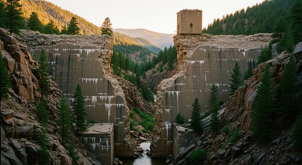
The crumbling concrete shell of the 1890 Castlewood Dam still stands in two massive broken halves, the gap between them marking the exact point where a 15-foot wall of water tore loose at 1 a.m. on August 3, 1933, and roared 40 miles down Cherry Creek to flood downtown Denver. You can walk right through that breach on established trails while the canyon walls and stunted pines make it feel genuinely remote and eerie.
→ Three more abandoned & forgotten places in Denver — never the same twice
The story
When engineers finished Castlewood Dam in 1890, locals already suspected it wouldn't hold. Built with a loose rock core capped in stone masonry, the structure leaked almost immediately, prompting four decades of downstream lawsuits and warnings that the dam was an accident waiting to happen. The dam's operators kept patching it up anyway. Then came 1 a.m. on August 3, 1933, when a heavy cloudburst overwhelmed the reservoir. The center section blew out, releasing 1.5 billion gallons of water in a 15-foot wall that roared 40 miles down Cherry Creek straight into downtown Denver.
That midnight deluge destroyed bridges and dumped 20,000 tons of thick silt across the city, but no one ever bothered to rebuild the dam. Instead, the park service left the shattered masonry where it fell. Today, two massive halves of stone and concrete abutments frame a raw gap in the canyon floor, surrounded by scrub oak and stunted ponderosa pine. Nature has reclaimed the streambed, but the sheer scale of the broken wall stands as a permanent monument to misplaced optimism.
What it's like
You'll pull into Castlewood Canyon State Park through the main east entrance on Highway 83 in Franktown, grab a daily vehicle pass at the self-service station, and park at the Visitor Center or Canyon Point lot. You can't drive to the dam—you'll hike about two miles round-trip on the Inner Canyon and Lake Gulch loops down into the canyon floor. The trail brings you right into the breach, where you can pick your way across tumbled stone blocks or climb the stairs to the top of the east abutment to stare down the canyon. Keep an eye on the clock: the park closes strictly at dusk, gates lock at sunset, and the gravel west entrance on the Castle Rock side does not connect by road.
The move: Hike the Castlewood Canyon Ruins Loop (roughly 2 miles) at dusk — pick your way through the broken dam gap, scramble up to the top of the standing east abutment for a panoramic view of the canyon, then find a quiet ledge along Cherry Creek below the ruins to sit with a thermos and watch the light fade over the same streambed that carried the flood.
📍 Before you go The ruins sit inside Castlewood Canyon State Park, so a daily vehicle pass is required (self-service stations at the gate — bring it). Use the main east entrance off Highway 83 in Franktown, where the visitor center and paved Canyon Point lot are; the breach is an easy walk in via the Inner Canyon/Lake Gulch loop. (A separate gravel west entrance off Castle Rock doesn't connect by car.) There's no parking at the dam itself — you hike to it. Best in spring through fall; the park closes at dusk, so a sunset visit means timing the gate — check seasonal hours ahead. Pair it with Castle Rock's restaurants a short drive west.
- 📍 Franktown
- 💸 Free
- ⚡ Up for anything
- 🌗 Outdoors
Where: 2989 S State Hwy 83, Franktown, CO 80116
Hours: Mined 2026-06-07 — confirm current hours before you go.
Pair it with
- Scileppi's at the Old Stone Church — After walking through 1890 dam ruins, head into Castle Rock for Italian food inside an 1888 rhyolite Catholic church where the bar occupies the former altar.
- B&B Cafe — Trade flood history for town history at this 1946 Castle Rock diner that still features vintage bullet holes in its ceiling and bar back.
- Provision — Pair a canyon trail hike with craft cocktails served behind a swinging bookcase in downtown Castle Rock.
- Wood Shark Trading Company — Follow up an eerie outdoor walk with a browse through taxidermy, oddities, and pocket knives at this family-owned Castle Rock shop.
More weird in Denver
Good to know
How do you get to the Castlewood Canyon Dam ruins?
Drive to the park's main east entrance at 2989 S State Hwy 83 in Franktown and park at the Visitor Center or Canyon Point lot. From there, hike in via the Inner Canyon and Lake Gulch loop trail.
Is there a pass required to visit?
Yes, a daily state park vehicle pass is required to enter Castlewood Canyon State Park and can be purchased at self-service stations at the gate.
When did Castlewood Dam collapse?
The dam collapsed at 1 a.m. on August 3, 1933, after heavy rain breached its notoriously unstable 1890 masonry structure, sending 1.5 billion gallons of water down Cherry Creek into Denver.
Can you visit the dam ruins after dark?
No, Castlewood Canyon is a day-use park open from sunrise to sunset, and the park entry gates lock at dusk.
Plan a visit & invite your people →
Further reading: cpw.state.co.us · coloradoencyclopedia.org · Tripadvisor
last checked: 2026-06-07