Entry No. 17 — the Grand Junction file — filed under: roadside-oddity
Redstone Coke Ovens
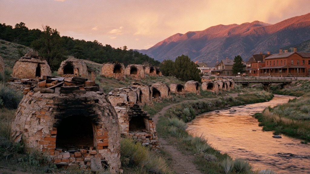
Those mounds along Highway 133 aren't ruins of some lost civilization — they're 90 of the original 249 beehive coke ovens CF&I fired up in 1899 for John Osgood's steel empire. Slack coal went in the top, burned at 2,400°F for 48 hours until everything but carbon cooked off, then got quenched with Crystal River water and shipped to the Pueblo blast furnaces. Dead by 1909. Pitkin County restored four nearly to firing condition; the rest crumble on purpose.
→ Three at a time, never the same twice — explore weird Grand Junction
The story
If you drive Highway 133 along the Crystal River, you'll pass what looks like a terraced row of ancient stone burial mounds bulging out of the brush. You didn't stumble on a lost prehistoric fort. In 1899, coal baron John C. Osgood and his Colorado Fuel & Iron Company built 249 beehive ovens along this exact curve to convert raw coal from nearby mines into pure, high-heat carbon coke.
The mechanics were brutal and precise: workers packed slack coal through top ports, sealed the stone arched doors, and let the coal burn at 2,400°F for 48 hours without oxygen. Once the volatile impurities cooked off, crews quenched the glowing carbon with freezing water pulled directly from the Crystal River—blasting plumes of superheated steam into the canyon—before shoveling the coke onto High Line narrow-gauge rail cars bound for the steel blast furnaces in Pueblo.
The entire enterprise burned out fast. By 1909, shifting supply chains and newer industrial processes killed the operation, abandoning the entire line of stone domes to freeze and thaw. Pitkin County eventually stepped in to rebuild four of the ovens nearly to firing condition, but they left the remaining 86 to crumble at their own pace along the 600-foot wall.
What it's like
Pull off Highway 133 into the small gravel patch at Chair Mountain Stables Road—there are no ticket booths, gates, or rangers. A flat, short gravel trail leads you along the 600-foot arc of stone domes. You can walk right up to the soot-blackened arched entrances, though stepping inside the open mouths is off-limits to keep the unreinforced masonry from collapsing on you. The walk takes about twenty minutes, dogs are allowed on leash, and the site stays open year-round.
The move: Time the McClure Pass drive for golden hour, walk the 600-foot arc of ovens together, then cross the river into Redstone's one-street downtown for a drink at the 1902 Redstone Inn.
📍 Before you go The ovens line the west side of Highway 133 right where Redstone Boulevard crosses the Crystal River into town; a small gravel pull-off with an interpretive plaque sits at Chair Mountain Stables Road. The self-guided path along the arc is flat and short — twenty minutes covers it, dogs welcome. It is an open roadside site with no gate, but stay out of the oven mouths; the unrestored ones are fragile and removing material is prohibited. Pair it with Redstone's boulevard of Osgood-era cottages and the castle across the river.
- 📍 Redstone
- 💸 Free
- ⚡ Up for anything
- 🌗 Outdoors
Where: Highway 133 at Chair Mountain Stables Road, Redstone, CO 81623
Hours: Added 2026-06-11 — confirm current hours before you go.
Pair it with
- Redstone Castle (Cleveholm Manor) — Drive four miles down the road to see where the coal baron who built these ovens spent his fortunes on gold-leaf ceilings and Tiffany lights.
- Marble Mill Site Park — Continue south along the river to explore another decaying early-1900s industrial ruin where Lincoln Memorial stone was sawn.
- Avalanche Ranch Hot Springs — Soak in tiered mineral hot springs nine miles back up the valley after walking the cold stone ovens.
- Basalt Charcoal Kilns — Compare Redstone's coal coke architecture with seven 1884 stone beehive kilns built across the ridge in Basalt for silver smelting.
More weird in Grand Junction
Good to know
How much does it cost to visit the Redstone Coke Ovens?
It is completely free and accessible right off the highway shoulder.
Can you climb inside the coke ovens?
No. Staying out of the oven mouths is strictly required to protect the fragile masonry and avoid rockfalls.
How long do I need for a stop here?
Twenty minutes is plenty of time to walk the full 600-foot arc, read the roadside interpretive plaque, and take photos.
Where is the pull-off located?
The gravel pull-off sits on the west side of Highway 133 at Chair Mountain Stables Road, right where Redstone Boulevard crosses the Crystal River.
Plan a visit & invite your people →
Further reading: Wikipedia · Official site · cpr.org · aspentimes.com
last checked: 2026-06-11