Entry No. 91 — the Durango file — filed under: historic
Sunnyside Mine
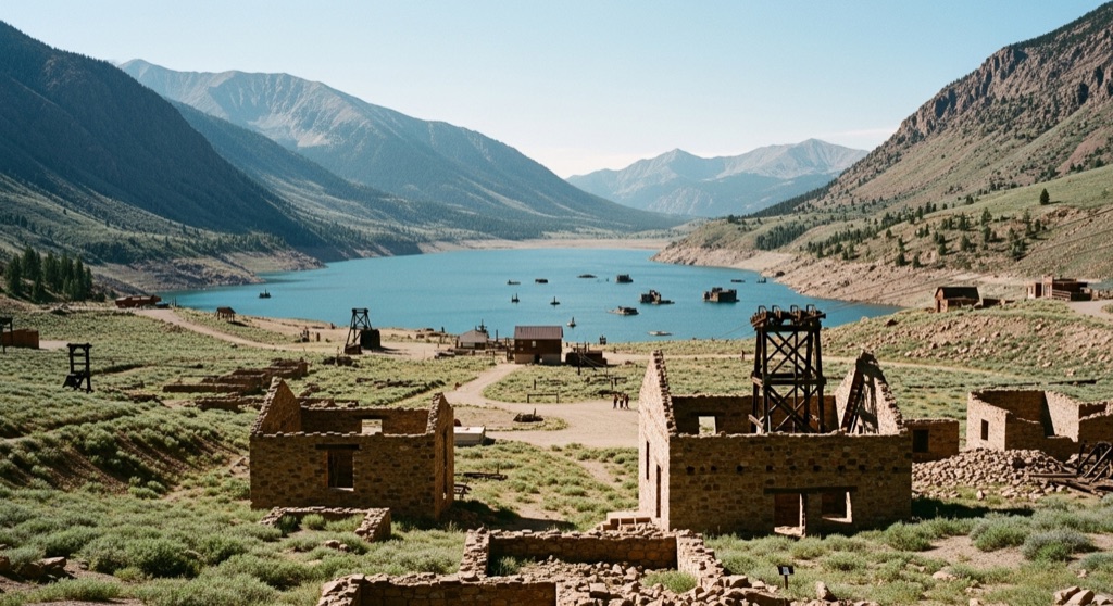
Established in 1873, the Sunnyside Mine was once one of Colorado's most productive gold and silver operations. In 1978, a catastrophic event occurred when the floor of Lake Emma collapsed directly into the mine tunnels, completely draining the lake and flooding the underground workings. Today, visitors can explore the dramatic empty lake basin and view the scattered remains of old mine foundations and aerial tramway structures.
→ Three more abandoned & forgotten places in Durango — never the same twice
The story
In 1873, miners staked out the Sunnyside Mine, carving high-altitude shafts that eventually turned it into one of Colorado's powerhouse gold and silver producers. But the site's most surreal moment unfolded in 1978, when crews tunneled a little too close to the bed of Lake Emma, a glacial tarn sitting thousands of feet up in the basin. The rock floor collapsed, sending the entire lake rushing straight down into the underground workings like water down a bathtub drain. Millions of gallons of water, mud, and ice blasted through miles of tunnels, sweeping heavy mining equipment out through lower portals. By pure luck, the blowout happened on a Sunday when no miners were working underground.
The mine was pumped out and resumed operations under Sunnyside Gold Corp, running until 1991 before shutting down for good. But plugging a hollowed-out mountain isn't that simple. Water continuous to drain through the complex, binding Sunnyside to decades of state settlements, Superfund monitoring, and the infamous 2015 Gold King Mine toxic wastewater spill nearby.
What's left today high above the tree line is an unnerving geological scar: the hollowed-out, dry basin where Lake Emma used to sit, framed by rusted cable hardware, timber fragments, Midway Mill ruins, and concrete foundations from old aerial tramways.
What it's like
To get up here, you'll need high clearance, four-wheel drive, or a serious pair of boots to navigate the public BLM Eureka Gulch road climbing out of the ghost town of Eureka. At over 11,000 feet, the terrain is raw, desolate, and heavily windswept even in mid-July. You're free to photograph the empty lakebed and surface structures from the public route, but keep your distance: every mine portal and shaft is strictly sealed, unstable, and actively monitored for toxic drainage. Treat the area as a open-air monument to engineering hubris and pack real cold-weather gear.
The move: Drive or hike up the scenic Eureka Gulch 4WD road to photograph the historic Midway Mill ruins, the dramatic empty basin of Lake Emma, and the surrounding San Juan peaks.
📍 Before you go The Eureka Gulch 4WD road is a public BLM route providing access to the area, but the mine workings themselves are extremely dangerous, sealed, and subject to ongoing environmental monitoring.
- 📍 Sunnyside Mine
- 💸 Free
- ⚡ Low-key
- 🌗 Outdoors
Where: Sunnyside Mine, Colorado 81433, USA
Hours: Added 2026-07-20 — confirm current access before you go.
Pair it with
- Sunnyside Mill foundation & ruins — At the bottom of the gulch, these massive stepped concrete ruins mark where the ore hauled out of the high Sunnyside tunnels was actually pulverized.
- Frisco Mill at Bagley Tunnel — Located nearby along the gulch, this 1912 prefabricated wooden mill offers another look at the high-altitude industrial remnants scattered around Silverton.
- Animas Forks Mine and Ghost Town — Just a short drive further up the Alpine Loop sits one of Colorado's most complete high-alpine ghost towns at 11,200 feet.
More weird in Durango
Good to know
What actually happened to Lake Emma?
In 1978, the floor of Lake Emma collapsed directly into the Sunnyside Mine workings beneath it, completely draining the alpine lake into the tunnels in a matter of hours.
Can you go inside any of the mine shafts?
No. All mine openings are strictly off-limits, hazardous, and sealed due to structural collapse risks and ongoing environmental containment.
How do you reach the Lake Emma basin and Sunnyside ruins?
Access is via the unpaved BLM Eureka Gulch 4WD road, which branches off the main Alpine Loop route near the Eureka townsite north of Silverton.
Is there a fee to visit?
No fees or permits are required to drive or hike the public BLM road to view the surface ruins and empty basin.
Plan a visit & invite your people →
Further reading: legendsofamerica.com · onxmaps.com · coloradosun.com · Wikipedia
last checked: 2026-07-20