Entry No. 54 — the Durango file — filed under: petroglyphs
McElmo Canyon Roadside Boulder Petroglyphs
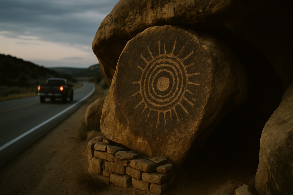
Someone decided the best place for a thousand-year-old petroglyph boulder was directly on the shoulder of County Road G, because moving it would destroy the site — so there it sits, six inches from passing pickup trucks, with concentric circles and a disc ringed by spiral rays carved into its face and zero interpretive signage to explain any of it. The boulder forms a natural rock shelter with neighboring stones; an ancient dry-stacked wall at the entrance suggests people once lived in the gap between them. It's technically part of Canyons of the Ancients National Monument, but the BLM doesn't advertise it and the pull-off is unmarked — you're on your own to find it about 600 feet west of the Cannonball Mesa Ruins trailhead before the road reaches the Utah border.
→ Three more abandoned & forgotten places in Durango — never the same twice
The story
You didn't hear it from us, but one of the finest thousand-year-old petroglyph panels in the Four Corners sits exactly six inches off the asphalt on County Road G, directly in the blast zone of passing pickup trucks. Most ancient art in North America gets hauled off to a museum vault or fenced behind ten-foot chain link. This sandstone boulder stayed put because moving it would have collapsed the natural rock shelter it forms with its neighboring stones. When the county paved the road toward Utah, they simply ran the blacktop right past its front face and kept moving.
Step into the tight gap between the boulders and you'll find an ancient dry-stacked stone wall blocking the entrance, showing that Ancestral Puebloans were using this exact wedge of rock as living quarters when McElmo Canyon was a thriving agricultural center. On the left rock panel, carved into the dark patinated stone, sits a central disc ringed by spiral rays and clear concentric circles. It remains starkly untouched, catching the low desert light exactly as it did ten centuries ago.
Technically, the site falls within the boundaries of Canyons of the Ancients National Monument, but you won't find a single Bureau of Land Management sign, brown highway marker, or plastic exhibit plaque pointing it out. The agency keeps it intentionally off the map to limit foot traffic. Modern graffiti has damaged the exposed right-hand face, but the sheltered interior and pristine left panel stay hidden in plain sight for anyone who knows which unmarked pull-off to look for.
What it's like
Drive County Road G west out of Cortez and keep your eyes peeled about 600 feet past the Cannonball Mesa Ruins trailhead. You're looking for a tiny, unmarked dirt shoulder on the right just before the boulder itself—if you pass the closed Ismay Trading Post or hit the Utah line, turn around. The road is fully paved so any passenger car can make the drive, but there is zero cell service and no restrooms out here, so download your maps ahead of time. It's a flat 0.03-mile walk from your bumper; ignore the vandalized right side of the rock and duck straight under the stone overhang to inspect the left panel, ideally at dusk when the slanting sunlight brings out the shallow spirals.
The move: Drive County Road G west from Cortez at dusk, pull off at the unmarked shoulder just before the boulder, and work the left panel images in low slanting light before dark swallows the canyon.
📍 Before you go Unmarked pull-off on the right shoulder heading west, just before the boulder — if you pass the closed Ismay Trading Post you've gone too far. Paved road, passenger car fine. 0.03-mile round trip on flat dirt; some petroglyph panels require ducking into the shelter. No cell service, no restrooms. Right-side panels are heavily graffitied; focus on the left panel.
- 📍 Cortez
- 💸 Free
- ⚡ Up for anything
- 🌗 Outdoors
Where: County Road G, Cortez, CO 81321
Hours: Added 2026-06-21 — confirm current hours before you go.
Pair it with
- Yucca House National Monument — Pair this roadside boulder with another unadvertised Ancestral Puebloan site nine miles away that sits unexcavated in a farmer's field.
- Lowry Pueblo & the Great Kiva — Continue your deep dive into Canyons of the Ancients by heading north to explore the masonry walls and preserved Great Kiva at Lowry Pueblo.
- Notah-Dineh Trading Company & Museum — Head back into Cortez after your canyon drive to compare raw outdoor rock art with the curated collection of regional artifacts in this basement museum.
- Ute Mountain Tribal Park — If you want to see more un-fenced Ancestral Puebloan ruins, arrange a guided trip into the neighboring tribal park led by Ute tribal members.
More weird in Durango


Good to know
How do I find the boulder without any official signs?
Drive west on paved County Road G from Cortez. Watch for the Cannonball Mesa Ruins trailhead, then drive roughly 600 feet further west to a small dirt pull-off on the right shoulder just before the stone.
Do I need a 4WD vehicle or high clearance?
No. County Road G is paved all the way to the site, making it completely accessible in a standard passenger car.
Are there restrooms or cell service at the site?
No. There are no facilities, trash cans, or cellular coverage in this section of McElmo Canyon, so bring water and download your route beforehand.
Which part of the boulder has the preserved petroglyphs?
The exposed right-side panel suffers from heavy modern graffiti; focus your attention on the left panel inside the natural rock shelter overhang to see the original spirals and concentric circles.
Plan a visit & invite your people →
Further reading: gjhikes.com · the-travel-life.com
last checked: 2026-06-21