Entry No. 223 — the Denver file — filed under: ruins
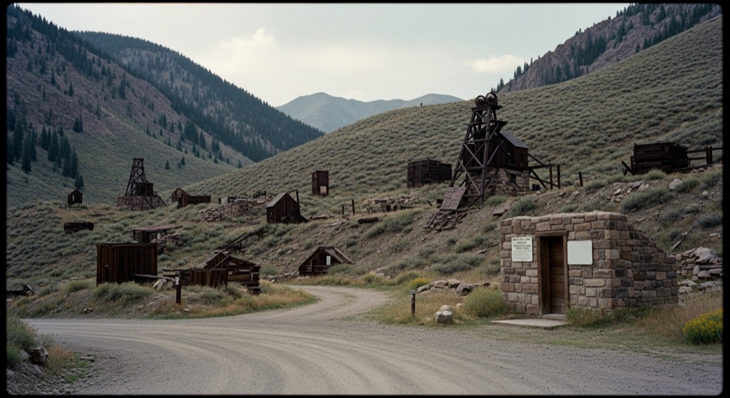
Old Town Mine
Located in the historic Russell Gulch mining district, the Old Town Mine was one of the most consistently profitable gold producers along the narrow-gauge Gilpin Tramway. Active from the late 1880s through the mid-20th century, its underground workings spanned over five miles and reached a depth of over 2,200 feet. Today, the site lies abandoned, with weathered ruins, old headframes, and tailings piles scattered across the rugged mountain landscape.
→ Three more abandoned & forgotten places in Denver — never the same twice
The story
You didn't hear it from us, but the most lucrative hole in Gilpin County isn't sitting under a neon casino sign in Black Hawk. It's rusting away in plain sight along County Road 279 in upper Russell Gulch. Active from the late 1880s through the mid-20th century, the Old Town Mine was the heavy hitter of the district, earning a reputation as the most consistently profitable ore producer along the two-foot narrow-gauge Gilpin Tramway. While lesser diggings folded after skimming surface quartz, mining engineer George K. Kimball controlled the operation for over two decades, directing crews that drove an inclined shaft 2,205 feet straight down across 21 distinct levels, eventually racking up more than five miles of underground tunnels.
To keep the deep workings from drowning in groundwater at 9,100 feet, Old Town's owners engineered a subterranean workaround: at the 21st level, they bored a 4,326-foot drain passage—cynically dubbed the 'Hot Time Lateral'—that connected directly to the four-mile-long Argo Tunnel under Quartz Hill to flush out water and circulate air. The vein was so complex that USGS geologists probing the lower shafts in 1952 even detected pitchblende uranium in the ore. Today, the engines are dead, leaving weathered timber headframes, slumping shaft houses, and iron-stained tailings piles melting back into the pine hillsides.
What it's like
Reaching Old Town Mine means driving County Road 279—locally known as 'Oh My God Road'—a narrow, dirt shelf road with washboard gravel, sharp switchbacks, and zero guardrails. As you reach the ridge in Russell Gulch, pull completely off into a public roadside turnout to take in the scene. The skeletal wooden headframes and sagging outbuildings sit on strictly private property in a hazardous historic district, surrounded by open pit risks and loose tailings, so crossing fences or trespassing is forbidden. Stay on the public road right-of-way with field glasses or a zoom lens. Late afternoon light brings out the contrast of the silvered, sun-bleached timbers against the rust-red mountain soil.
The move: Drive along the scenic, unpaved County Road 279 (Virginia Canyon Road) to safely view and photograph the historic headframes, ruins, and tailings of the Old Town Mine and nearby ghost town structures from the public roadside.
📍 Before you go The mine ruins and surrounding structures are located on private property in a hazardous historic mining district, but they can be legally viewed and photographed from the public County Road 279.
- 📍 Old Town Mine
- 💸 Free
- ⚡ Low-key
- 🌗 Outdoors
Where: Old Town Mine, Colorado 80452, USA
Hours: Added 2026-07-20 — confirm current access before you go.
Pair it with
- Edgar Experimental Mine — Pair your view of Old Town's surface ruins with a tour of Edgar Mine down the canyon to see how 19th-century hard-rock mining actually worked underground.
- The Face on the Barroom Floor — Follow the road into Central City for a drink where a rogue artist secretly painted a woman's face on the Teller House saloon floor in 1936.
- Knights of Pythias Cemetery — Drive two miles over the ridge toward Black Hawk to visit a secretive fraternal hilltop cemetery where early boomtown miners were buried.
- Indian Hot Springs Geothermal Caves — Wash off the gravel dust from Oh My God Road by soaking in geothermal mineral caves carved straight into the mountainside below Idaho Springs.
More weird in Denver

Good to know
Can I walk around or go inside the Old Town Mine buildings?
No. The mine ruins, headframes, and tailings sit on private property in a hazardous historic mining district. You must view and photograph the site legally from the shoulder of public County Road 279.
How did the mine drain water from over 2,000 feet underground?
At its lowest level, 2,205 feet down, workers blasted the 4,326-foot 'Hot Time Lateral' tunnel, which connected directly to the Argo Tunnel beneath Quartz Hill for gravity drainage and ventilation.
What kind of vehicle do I need to drive County Road 279?
County Road 279 ('Oh My God Road') is an unpaved, narrow gravel road with steep drop-offs and washboards. Standard passenger cars can usually handle it slowly in dry summer weather, but high-clearance or 4WD vehicles are recommended.
Why is Virginia Canyon Road called 'Oh My God Road'?
The nickname dates back to early travelers navigating its two-way narrow shelf lanes, 12% grades, severe switchbacks, and complete lack of guardrails above Idaho Springs.
Plan a visit & invite your people →
Further reading: pubs.er.usgs.gov · 4x4explore.com
last checked: 2026-07-20