Entry No. 171 — the Denver file — filed under: outdoor
Forsythe Canyon Waterfall Trail
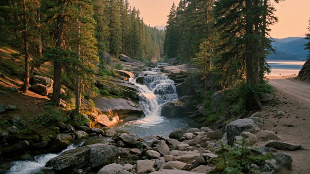
Everyone funnels into Boulder's marquee trails and never turns up Magnolia Road, which is exactly why this one stays quiet. You drop into a shaded conifer canyon and walk alongside Forsythe Creek as it tumbles over granite into a string of small waterfalls — loudest and most dramatic during spring snowmelt. A short rocky scramble takes you to the base of the main falls, and if you keep going the canyon opens onto the blue sprawl of Gross Reservoir. It's a creek-side walk that feels secret: mossy rock, rushing water, and a lake terminus, all hidden behind a dirt road most Front Range day-trippers won't bother driving.
→ Three more hidden bars & speakeasies in Denver — never the same twice
The story
While Front Range day-trippers choke the trailheads around Chautauqua and Flagstaff Mountain, the smart move is bypassing them entirely and pointing your vehicle up Magnolia Road (CR 132). Magnolia climbs out of Boulder Canyon on steep, unpaved switchbacks with grades plunging past 14 percent—the kind of mountain dirt road that smells like hot brake pads and scares off casual traffic. Tucked off National Forest System Road 359 in Roosevelt National Forest sits a small gravel lot that serves as the quiet entryway to Trail #852.
Stepping past the gate, you drop straight into a shaded granite canyon carved by Forsythe Creek. Dense stands of ponderosa pine, Douglas fir, and spruce block out the sun while you follow the creek downhill. In late spring and early summer, snowmelt rushing off the high country turns the stream into a loud torrent cascading over granite steps, culminating in a hidden 15-to-25-foot waterfall squeezed tight between rock walls.
The real reward sits just beyond the cascade. Scrambling down the rocky cliff side past the falls brings you out of the shaded canyon directly onto a sandy, boulder-strewn cove at Gross Reservoir. Constructed by Denver Water in 1954 at 7,225 feet elevation, this 440-acre impoundment stores Western Slope water funneled through the Continental Divide via the 13-mile Moffat Tunnel. Emerging from a close-walled, mossy forest walk straight onto a expansive alpine reservoir feels like discovering a backcountry secret hidden in plain sight.
What it's like
You'll pull off CR 68 into a small gravel lot equipped with a wooden fence and a vault toilet. The hike along Trail #852 is a gentle, mostly shaded creek-side walk for about a mile until you reach the top of the waterfall, where the main path fades and forces you down a short, loose dirt-and-rock scramble along the cliff side to reach the base. Continuing another 200 yards brings you to the quiet shore of Gross Reservoir. Keep your boots on at the water's edge—Denver Water strictly prohibits swimming, wading, or cliff jumping to protect the municipal water supply. Parking is tight and fills fast on summer weekends, and high-country weather at 8,000 feet can shift rapidly, so shift into low gear on the steep dirt drive down, start your hike early to beat afternoon thunderstorms, and bring warm layers.
The move: Make the drive the date: load up coffee, point the car up Magnolia Road, and let the dirt-road climb out of Boulder be the part where you actually talk. Then wander the canyon together to the falls, sit on a rock where the creek drowns out everything else, and push on to the reservoir to watch the water if the day's holding. A small, earned, off-the-map afternoon — not a scene, just the two of you and a creek nobody else found.
📍 Before you go About 2.9 miles round trip to Gross Reservoir with roughly 396 ft of gain — mostly easy, near-flat creek-side walking, with one short rocky scramble down to the base of the falls (the only technical bit). The falls are at their best in late-spring/early-summer snowmelt; the trail itself is generally accessible roughly May through October. It sits in Roosevelt National Forest — no fee or permit to hike (fishing the reservoir needs a valid Colorado fishing license). Getting there means several miles of dirt road: a 4WD/high-clearance vehicle isn't required via Magnolia Road, but the approach has steep grades (14%+ descents where drivers report overheating brakes), so go slow and gear down. In winter the road is gated 2 miles earlier at Magnolia/CR 68, which stretches the round trip to about 6.2 miles. This is high country (~8,000 ft) — afternoon thunderstorms build fast in summer, so start early, carry layers and water, and turn around if the sky darkens. The lot is small and fills on weekends.
- 📍 Nederland / Gross Reservoir (Boulder County)
- 💸 Free
- ⚡ Up for anything
- 🌗 Outdoors
Where: Forsythe Canyon Trailhead, off National Forest System Road 359 in Roosevelt National Forest. From Boulder, take Hwy 119 (Canyon Blvd) toward Nederland, then Magnolia Road (CR 132) west about 6.6 miles to County Road 68; follow CR 68 roughly 2 miles to the gravel parking lot (restroom, wooden fence) just before the gate on NFSR 359. Reach Magnolia Road from Boulder rather than Lakeshore Road — it is the easier approach.
Hours: Day-use, free. Best season: Late spring / early summer (peak snowmelt for the waterfalls); trail generally accessible May–October. Confirm trail & road conditions before you go.
⚠ Seasonal or scheduled — always check before you go.
Pair it with
- Carousel of Happiness — Head six miles up the road to Nederland after your hike to ride Scott Harrison's 56 hand-carved wooden animals inside a restored vintage carousel.
- License No. 1 — Drive back down to Boulder and slip into the dim basement speakeasy beneath Hotel Boulderado to sip cocktails under the city's very first post-Prohibition liquor license.
- Fiske Planetarium Laser & Liquid Sky Shows — Pair a quiet morning along Forsythe Creek with an immersive late-night music and laser show under CU Boulder's 65-foot planetarium dome.
- Sommers-Bausch Observatory Open House Nights — Finish your day of outdoor exploring by heading to CU Boulder's campus on a clear Friday night for free open-house stargazing on the rooftop deck.
More weird in Denver
Good to know
How do I get to the Forsythe Canyon Trailhead safely?
From Boulder, take Highway 119 into Boulder Canyon, turn onto Magnolia Road (CR 132) and go west 6.6 miles to CR 68, then follow CR 68 for 2 miles to the gravel lot at NFSR 359. Gear down into low gear on the 14%+ steep dirt descents to prevent your brakes from overheating.
How long and difficult is the hike?
It is roughly 2.9 miles round trip to Gross Reservoir with about 396 feet of elevation gain. Most of the trail is an easy, mostly flat downhill stroll along Forsythe Creek, with the only technical section being a short, rocky scramble to reach the base of the waterfall.
Are swimming or water sports allowed at Gross Reservoir?
Swimming, wading, and cliff jumping are strictly prohibited by Denver Water to preserve drinking water quality. However, non-motorized watercraft like kayaks and SUPs are permitted, and fishing is allowed with a valid Colorado fishing license.
When is the best time of year to visit?
Late spring through early summer (May to June) offers the heaviest water flow over the falls due to peak snowmelt. The trail is generally accessible May through October; winter road closures at Magnolia and CR 68 add roughly 3.3 miles to the trek.
Do I need a permit or fee to park and hike?
No. The trail sits on public land within Roosevelt National Forest, and there are no parking fees or hiking permits required for day use.
Plan a visit & invite your people →
Further reading: Official site · dayhikesneardenver.com · cchikes.com · Wikipedia · fs.usda.gov
last checked: 2026-06-10