Entry No. 134 — the Denver file — filed under: fire-tower
Devil's Head Lookout
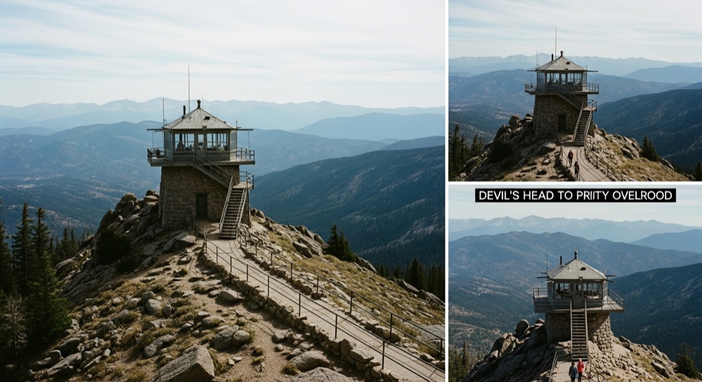
Devil's Head is Colorado's last staffed fire lookout — a working ranger mans the historic 1912 tower from roughly mid-May through mid-September, and on a clear day the 143-stair climb to the cab rewards you with a jaw-dropping 360-degree panorama stretching 100 miles across the Front Range. The ranger typically welcomes small groups up into the cab and will point out landmarks and chat about how the fire-detection equipment still works.
→ Three more weird outdoor & roadside oddities in Denver — never the same twice
The story
In 1912, the U.S. Forest Service bolted a wooden lookout to a granite pinnacle 9,748 feet up in the Pike National Forest to spot rising smoke before fires wiped out the valley. While satellites and infrared drones replaced almost every other lookout tower across North America, Devil's Head never got the memo. It remains Colorado's last seasonally continuously staffed fire lookout—a working relic where a ranger still lives from mid-May through mid-September, scanning the trees through heavy binoculars instead of relying on a computer screen.
The tower has a history of quietly ignoring standard procedure. In 1919, when World War I triggered a shortage of male foresters, officials hired 30-year-old Denver local Helen Dowe to man the rock solo. She became the second female lookout in U.S. Forest Service history, spending three seasons mapping fires with a hand-sighted alidade table and sending telegraph warnings before flames reached civilization. The original cabin was replaced in 1951, but the core routine hasn't shifted: one human locked in a glass box, keeping tabs on 100 miles of Front Range horizon.
What makes this place weird isn't just the altitude—it's that you're allowed inside a functioning federal nerve center. Once you conquer the final 143 steel-and-timber stairs anchored into sheer granite, you're standing on the catwalk of an active workplace. Stepping inside the cab, the ranger will let you look through the sights of an Osborne Fire Finder—a mechanical sighting device from the early 1900s—and explain how manual geometry still beats modern sensors when lightning hits the ridge.
What it's like
Reaching the trailhead requires enduring about nine miles of brutal, washboard dirt on Rampart Range Road—take it slow unless you want to rattle your bumper off. From the parking lot, the hike climbs 1.4 miles and roughly 900 vertical feet through lodgepole and ponderosa pine. There's a wooden shelter halfway up if your lungs complain about the 9,000-plus-foot elevation, but the real test is at the top: 143 narrow stairs hung over open granite drop-offs. Because the cab only holds a handful of visitors at a time, expect a short queue on summer weekends while the ranger rotates small groups through. Come early on a weekday morning if you want to skip the crowd, and keep in mind that while dogs are fine on the dirt trail, they are strictly forbidden from setting paw on the tower stairs or inside the glass lookout.
The move: Arrive mid-morning on a weekday to beat weekend crowds, hike the 1.4-mile trail through ponderosa forest to the granite outcrop, then climb all 143 stairs together into the lookout cab — the ranger will narrate the view and show you the Osborne Fire Finder. Pack a lunch to eat on the rocks just below the tower with the Rockies sprawling in every direction, then take the short spur to the lookout's privy overlook for a second angle before heading back down.
📍 Before you go It sits atop Rampart Range Road, a rough gravel-and-dirt forest road off Highway 67 west of Sedalia — dusty and washboarded, but passable in a regular car if you take it slow. From the trailhead it is a 1.4-mile climb, with a halfway shelter for a breather. The tower only operates roughly mid-May through mid-September, and the road closes for winter around December 1, so summer to early fall is your window. The small lot fills early, so come on a weekday morning. Heads up: dogs must stay leashed and are not allowed on the tower stairs or in the cab. An adjacent first-come campground can make it an overnight.
- 📍 Sedalia
- 💸 Free
- ⚡ Up for anything
- 🌗 Outdoors
Where: 6518 S Rampart Range Rd, Sedalia, CO 80135
Hours: Mined 2026-06-07 — confirm current hours before you go.
Pair it with
- A Sanctuary Center — After descending Rampart Range Road, trade high-altitude fire watch for a quiet walk through a volunteer-kept sacred garden with a stone medicine wheel and labyrinth.
- Cherokee Ranch & Castle — Pair a wild mountain summit with a surreal prairie landmark—a 15th-century Scottish-style stone castle built by a local ranching heiress.
- Scileppi's at the Old Stone Church — Reward your legs after the 143-step climb with Italian food inside an 1888 rhyolite Catholic church where the bar sits where the altar used to be.
- Provision — Swap a remote 9,700-foot watchtower for a hidden craft cocktail speakeasy tucked behind a swinging bookcase in Castle Rock.
More weird in Denver


Good to know
When is the lookout tower open to visitors?
The ranger staffs the lookout cab from roughly mid-May through mid-September. The trail is accessible longer into the fall, but Rampart Range Road typically closes to vehicles around December 1 for the winter.
How difficult is the hike to Devil's Head Lookout?
It is a 1.4-mile climb each way with about 900 feet of elevation gain, starting at over 8,800 feet elevation. A shelter sits halfway up for resting before you tackle the final 143 stairs anchored into the granite summit.
Can I bring my dog on the trail and up into the tower?
Dogs are welcome on the 1.4-mile forest trail as long as they stay leashed, but they are strictly prohibited on the 143 tower stairs and inside the ranger's cab.
Do I need four-wheel drive to get to the trailhead?
No, normal passenger cars can make the trip on Rampart Range Road off Highway 67, but the road is unpaved, dusty, and heavily washboarded, so you will need to drive slowly.
Is there an entry or parking fee?
No, access to the Devil's Head trail, the parking lot, and the historic fire tower is free to the public.
Plan a visit & invite your people →
Further reading: fs.usda.gov · Tripadvisor · Yelp · intermountainhistories.org · coloradoencyclopedia.org · Wikipedia
last checked: 2026-06-07