Entry No. 186 — the Denver file — filed under: cold-war
Camp Hale–Continental Divide National Monument
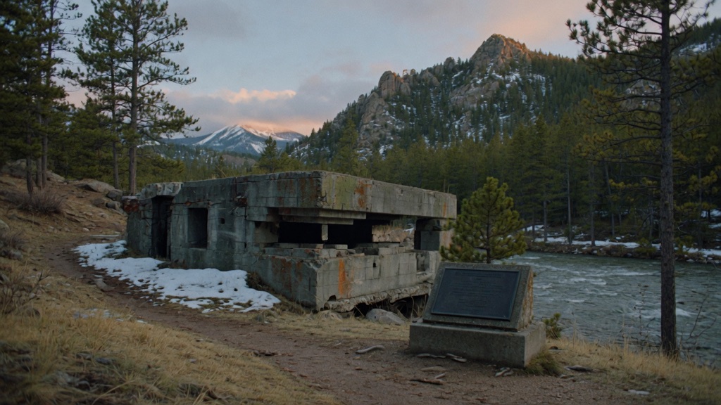
Those concrete bunker ruins along the Eagle River aren't just 10th Mountain Division leftovers. From 1958 to 1964 the CIA ran 'Dumra' — the garden — here, secretly training some 300 Tibetan guerrillas for the Dalai Lama's resistance while a planted Denver Post story about atomic testing kept Leadville locals away. A plaque finally admitted it in 2010, but nobody knew exactly where Dumra stood until 2024, when a CU anthropologist matched 1963 photos to ridgelines on snowshoes and the last surviving CIA trainer confirmed it.
→ Three more abandoned & forgotten places in Denver — never the same twice
The story
Before it was designated a national monument in 2022, Camp Hale was famous primarily as the high-altitude proving ground where the U.S. Army's 10th Mountain Division learned to ski and shoot during World War II. But the valley's weirder, far more clandestine chapter unfolded a decade later. From 1958 to 1964, under the covert program ST CIRCUS, the CIA took over a secluded section of the valley floor, code-naming it "Dumra"—Tibetan for "The Garden." Here at 9,200 feet, where the Rocky Mountain terrain closely mirrored the high Himalayan plateau, agents trained approximately 300 Tibetan guerrillas in radio operation, Morse code, parachuting, and guerrilla warfare to fight the Chinese occupation of Tibet.
To keep locals in nearby Leadville and Minturn from asking questions about guarded perimeters and strange aircraft, the government planted a decoy story in the Denver Post claiming the valley was being cleared for atomic testing. The secret held for decades. Even after a bronze memorial plaque acknowledging the Tibetan Freedom Fighters was erected near the bunker remnants in 2010, the exact geographic footprint where Dumra's structures stood remained unknown. It took until 2024 for University of Colorado anthropologist Carole McGranahan to trek into the valley on snowshoes, align 1963 archival photographs with the surrounding mountain ridgelines, and have the exact site confirmed by former CIA instructor Bruce Walker.
Today, no secret fences or guard posts remain—just concrete weapon bunker ruins, foundation pads, and quiet stands of aspen framing the Eagle River. The history of one of the Cold War's most unusual domestic operations sits completely exposed to anyone willing to drive the valley loop.
What it's like
Arriving at Camp Hale feels like pulling into a vast, quiet mountain bowl where history is slowly being reclaimed by alpine meadows. You'll enter off US Highway 24 through twin stone pillars onto Forest Road 714, a flat dirt loop road circling the valley floor. Near the concrete bunker ruins along the river, you'll find the bronze Tibetan Freedom Fighters plaque framed by wooden fencing. The key detail to remember: this entire valley was an active heavy-weapons training ground, and unexploded ordnance still turns up in the dirt. Rangers strictly enforce staying on established roads and packed trails—no bushwhacking. Bring warm layers even in July due to the high altitude, and note that the dirt loop becomes a snowshoe track when snow closes the road from November through May.
The move: Walk the old camp loop off Forest Road 714, find the Tibetan Freedom Fighters plaque near the bunker remnants, and read its inscription aloud where the secret garden stood.
📍 Before you go The stone-pillar entrance off US 24 leads to a dirt loop road (Forest Road 714) around the valley floor — fine for most cars in summer, but snowed under roughly November through May, when it becomes snowshoe terrain. The plaque and interpretive signs sit near the bunker remnants on flat, exposed ground at 9,200 feet, so carry layers even in July. Unexploded ordnance still turns up in this valley; stay on roads and established paths. Pair it with lunch in tiny Red Cliff or the Tennessee Pass overlook ten minutes south.
- 📍 Red Cliff
- 💸 Free
- ⚡ Up for anything
- 🌗 Outdoors
Where: Main entrance off US Hwy 24, ~17 mi south of I-70 at Minturn (stone pillars), Red Cliff, CO 81649
Hours: Added 2026-06-11 — confirm current hours before you go.
⚠ Seasonal or scheduled — always check before you go.
Pair it with
- Castlewood Canyon Dam Ruins — Pair Camp Hale's concrete military ruins with the massive, fractured concrete shell of Castlewood Canyon Dam for a double feature of abandoned high-country engineering.
- Mount Falcon 'Summer White House' Ruins — Combine the CIA's secret alpine training site with the stone fireplace ruins of a never-completed 22-room presidential retreat in the Front Range foothills.
- Rattlesnake Gulch Trail — Match the valley-floor trek through Cold War history with a canyon hike up to the charred foundation ruins of the historic Crags Hotel.
More weird in Denver
Good to know
Where is the CIA "Dumra" memorial site located within Camp Hale?
The plaque and interpretive markers are situated near the concrete bunker remnants off Forest Road 714, accessible via the main stone-pillar entrance on US Highway 24.
When is the best time of year to visit?
June through October provides dry dirt-road access for standard passenger cars. From November through May, the road is buried in snow and accessible only by snowshoes or cross-country skis.
Is there an admission fee or visitor center on-site?
No, access to the national monument is free, and there are no staffed visitor centers, gas stations, or food services inside the monument boundaries.
Is it safe to hike around the ruins?
Yes, provided you stay on established roads and paths. Unexploded military ordnance remains scattered in the soil, so wandering off-trail into uncleared brush is unsafe.
Plan a visit & invite your people →
Further reading: colorado.edu · rfa.org · fs.usda.gov · coloradoencyclopedia.org · cia.gov
last checked: 2026-06-11