Entry No. 43 — the Denver file — filed under: hidden-history
Buried 1893 Streetcar Tracks Under South Pearl Street
“130-year-old infrastructure that almost everyone walking to brunch never notices”
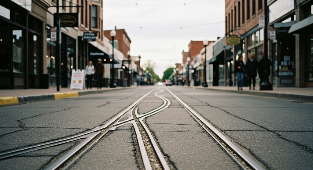
The entire South Pearl commercial strip exists because the Denver Tramway Company ran a streetcar line up it starting in June 1893, the trolley is why every storefront here was built. When the streetcars died around 1950, the city didn't rip the rails out; it just paved over them. On a few stretches the asphalt has worn thin enough that the original steel rails poke back through, and you can stand on 130-year-old infrastructure that almost everyone walking to brunch never notices.
→ Three more weird outdoor & roadside oddities in Denver — never the same twice
The story
In June 1893, the Denver Tramway Company laid steel tracks down South Pearl Street from Alameda to Jewell Avenue, effectively inventing the commercial strip you're standing on. Before electric trolleys rolled down the middle of the road, this was quiet prairie on the rural fringe of Denver. Within years, the transit line catalyzed the entire grid, bringing grocers, bakeries, pharmacies, and barbers to serve disembarking commuters. When streetcar service was permanently shut down in 1950, city crews didn't spend the money or manpower to rip up miles of heavy steel. They took the lazy route and paved asphalt directly over top of them.
Because those 130-year-old rails were left entombed beneath the street, they never actually went anywhere. Across the 1400, 1500, and 1600 blocks of South Pearl, decades of freeze-thaw cycles, heavy delivery trucks, and constant commuter traffic routinely chew through the thin asphalt overlay. Look down as you walk, and the grey pavement gives way to glints of exposed, rusted steel poking back through the cracks—a phantom transit grid lurking inches beneath the feet of patio diners.
You won't find an official historic plaque or municipal sign marking the spots, and the city isn't advertising that its road surfacing is wearing away. Because exposed patches shift every time public works throws down fresh asphalt, finding the rails requires treating a casual neighborhood stroll like a low-key urban archaeological survey. Scan near cross-streets and along center-lane tire grooves where traffic wears the topcoat thinnest.
What it's like
Walking these blocks feels like catching municipal infrastructure in a quiet mid-renovation oversight. You'll be strolling past cafes and storefronts while staring obsessively at the pavement beneath your boots. The trick is lighting: visit in early morning or late afternoon when low, raking sunlight casts distinct shadows off the metal edges poking through the asphalt. Keep an eye out for live traffic while scanning the roadbed, and don't expect a permanent fixed location—just walk slowly between Alameda and Jewell, watching the asphalt cracks where 1890s steel bleeds through.
The move: Make it a low-key urban-archaeology hunt: walk the 1400-1600 blocks scanning the pavement for the rail lines surfacing through cracks, then debate over coffee how the trolley shaped the whole street.
📍 Before you go The rails surface along the South Pearl commercial strip in Platt Park, roughly the 1400-1600 blocks; there's no marked spot, so plan to walk slowly and scan cracks, worn patches, and near intersections where the asphalt overlay has thinned. Daylight is essential, and low, raking morning or late-afternoon light makes the steel easier to catch. This is a live public street, so watch traffic and parked cars and stay out of the roadway. Pair it with the strip's cafes and restaurants, and aim for a Sunday in the warm months (roughly May through mid-November), when the South Pearl Street Farmers Market fills these same blocks. Exposed sections shift with repaving, so don't expect them in a fixed place.
- 📍 Platt Park / South Pearl Street
- 💸 Free
- ⚡ Low-key
- 🌗 Outdoors
Where: Embedded in the pavement along roughly the 1400-1600 blocks of S Pearl St, Denver, CO 80210; visible where the asphalt overlay has worn thin (no fixed point).
Hours: Outdoor public street, viewable anytime; daylight best for spotting rails. Exact visible spots shift with repaving, so it may take a walk to find an exposed section.
Pair it with
- Fifty-Two 80s: A Totally Awesome Shop — Walk four blocks west to South Broadway to trade 1890s transit ruins for 1980s pop-culture artifacts jammed into 900 square feet.
- Spectra Art Space — Head just half a mile west to swap accidental street history for hand-built, walk-through immersive art installations.
- The Oddemporium — Follow South Broadway north onto Antique Row to continue hunting hidden history among floor-to-ceiling medical and historical curiosities.
- Chamberlin Observatory (Denver Astronomical Society Public Nights) — Head east down Jewell Avenue to pair street-level 1890s ironwork with an 1890s red-sandstone astronomical observatory.
More weird in Denver

Good to know
Where exactly on South Pearl Street can I spot the buried tracks?
Scan the pavement along the 1400 to 1600 blocks of South Pearl Street in Platt Park; exact visible patches shift as asphalt wears down or gets re-paved, so inspect cracks near intersections and high-wear traffic lanes.
Is there a fee or guided tour to see the rails?
No, it is entirely free and viewable anytime on a public city street, though daylight—specifically low morning or late afternoon raking light—makes the steel much easier to spot.
Why didn't the city remove the streetcar rails when service ended?
When Denver Tramway Company ended streetcar operations in 1950, pouring asphalt directly over the embedded steel tracks was vastly cheaper and faster for the city than excavating miles of solid rail.
Can I bring equipment to detect or unearth them?
No—this is an active public roadway with vehicle traffic. Keep your search strictly visual, stay out of driving lanes, and watch for passing cars.
Plan a visit & invite your people →
Further reading: Official site · denverurbanism.com · Reddit
last checked: 2026-06-07