Entry No. 50 — the Colorado Springs file — filed under: outdoor
Red Rocks Trail Loop (Woodland Park)
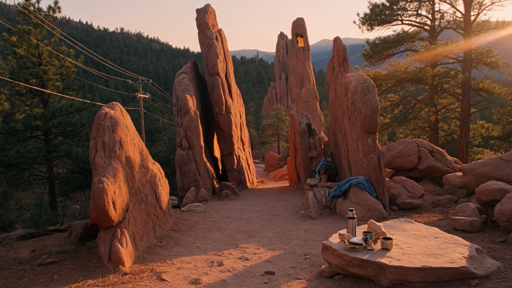
Everyone within an hour of Colorado Springs has done Garden of the Gods. Almost nobody has done its quieter twin. Tucked into ponderosa forest north of Woodland Park, this cluster of red sandstone fins rises narrower and taller than the famous ones — and you'll likely have them to yourself. There's no grand trailhead sign, just power lines pointing the way. Within half a mile the trees open onto towering rust-colored rock you can wander behind, scramble into, and lose an afternoon among. The maintained path frays as the formations multiply, which is the charm: past the first set, the route becomes "pick a rock and go explore."
→ Three more weird outdoor & roadside oddities in Colorado Springs — never the same twice
The story
While tourists queue up by the busload at Garden of the Gods and clog the paved loops at Red Rock Canyon Open Space, three miles north of Woodland Park sits a sandstone cluster that Pike National Forest barely bothers to signpost. If you aren't actively watching for the turn off CO-67 onto Forest Service Road 335, you will cruise right past it toward Deckers without ever knowing a maze of towering rust-colored fins is sitting in the pine forest just off the pavement.
These formations share the same 300-million-year-old Fountain Formation sandstone as their famous neighbor down in Colorado Springs, but at 8,200 feet, the setting is completely different. The fins rise narrower and taller out of a floor of ponderosa pine needles, and there are no paved ribbons, gift shops, or velvet ropes keeping you back. Instead, you follow a set of overhead power lines for a tenth of a mile into the woods until the trees part, the maintained path frays, and the terrain hands you a choice of sandstone corridors to scramble through.
What it's like
You pull off onto the dirt shoulder of Forest Service Road 335A, where the complete absence of a trailhead sign is your first cue that you've escaped the crowds. Look up, find the overhead power lines cut through the ponderosas, and walk beneath them until the woods open up onto the first cluster of towering red sandstone. Once you reach the fins, the official path breaks into a maze of user-created social trails, leaving you to climb into narrow rock splits and scout high viewpoints on your own. The vibe is quiet and unsanctioned—you'll mostly hear wind through the trees rather than other hikers. Just bring an offline map on your phone, because the web of unmapped dirt paths makes it shockingly easy to lose your direction, and keep an eye on the sky for the sudden afternoon lightning storms typical of high-elevation Teller County.
The move: Make the finding the date. Drive up from the Springs, park at the unmarked pull-off, and follow the power lines into the trees together — no signs, no crowd, just the two of you hunting for the first flash of red rock. When the trail dissolves among the formations, let it: split up to scout, scramble into the fins, and meet back to compare which hidden corner each of you found. Pack a thermos and something to eat, then claim a warm slab of sandstone for a quiet picnic before heading back down.
📍 Before you go An easy 3.2-mile loop with about 400 ft of gain through pine forest to scattered red sandstone formations — figure 1 to 1.5 hours, longer if you scramble. Getting there: from Colorado Springs take US-24 west into Woodland Park (~30 min), turn north on CO-67 ~3 mi, then right onto FSR 335 at the Red Rocks Group Campground sign and bear right at the "Y" onto 335A. There's no trail-map sign at the start; the maintained path also disperses among the rocks, so download an offline map and note your turnaround — it's easy to wander off-route. Sits around 8,000+ ft: best March–October, with summer afternoon thunderstorms a real risk (start early, watch the sky) and snow, mud, and a rougher dirt-road approach likely in winter/shoulder season. National Forest land, no entrance fee; dogs welcome on leash. Carry your own water — none available — and pack out everything.
- 📍 Woodland Park / Pike National Forest
- 💸 Free
- ⚡ Up for anything
- 🌗 Outdoors
Where: Red Rocks (Trail #708) area, Pike National Forest, ~3 mi north of Woodland Park. From the Hwy 24/67 intersection in Woodland Park, head north on CO-67 toward Deckers about 3 miles, then turn right onto Forest Service Rd 335 at the Red Rocks Group Campground sign. Just past the campground, bear right at the "Y" onto FSR 335A to the dirt pull-off. There is no trail-map sign at the start — look for the overhead power lines and follow them roughly a tenth of a mile to the first formations.
Hours: Day-use, free. Best season: March–October (snow possible off-season; summer afternoons bring thunderstorms). Confirm trail & road conditions before you go.
⚠ Seasonal or scheduled — always check before you go.
Pair it with
- Green Mountain Falls Skyspace — A short drive back down Highway 24, swap unscripted outdoor scrambling for an enclosed mountain chamber where you view the sky through a precision oculus.
- Rainbow Falls ("Graffiti Falls") — Head down Ute Pass to Manitou Springs to follow your forest hike with a stop at a canyon waterfall tucked beneath a highway bridge and layered in vibrant graffiti.
- Horsethief Falls Trail — Trace CO-67 south past Divide to combine this red rock loop with a forest path that passes a historic 1890s railroad tunnel on the way to a tucked-away waterfall.
- Cripple Creek Wild Donkey Herd — Follow Highway 67 further south into Cripple Creek to encounter the free-roaming herd of feral donkeys descended from turn-of-the-century gold mining pack animals.
More weird in Colorado Springs
Good to know
Is there an entry fee or trailhead pass needed?
No. The loop sits on public Pike National Forest land, so parking and hiking are completely free.
How long is the hike and how difficult is it?
It is an easy 3.2-mile loop with roughly 400 feet of elevation gain. Plan on 1 to 1.5 hours for the walk itself, plus extra time if you plan to stop and scramble up the rock fins.
Can I bring my dog?
Yes, dogs are welcome on the trail but must remain on a leash.
How do I find the trailhead if there are no signs?
Drive roughly 3 miles north of Woodland Park on CO-67, turn right onto FSR 335 at the Red Rocks Group Campground sign, bear right onto 335A, and park at the dirt pull-off. From there, follow the overhead power lines into the forest for about a tenth of a mile until you spot the sandstone.
When is the best season to hike this loop?
March through October offers the clearest paths. Sitting above 8,000 feet, the unpaved approach road and trail see heavy mud and snow in winter, while summer afternoons regularly bring fast-moving lightning storms.
Plan a visit & invite your people →
Further reading: fs.usda.gov · Official site · springsmag.com · theoutbound.com · hikingproject.com · Reddit
last checked: 2026-06-10