Entry No. 52 — the Wichita file — filed under: gypsum-hills
Gyp Hills Wildlife Area (Gypsum Hills)
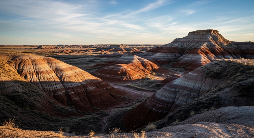
A remote pocket of red-earth gypsum hills, mesas, and hidden canyons in south-central Kansas — sculptural, pastel-banded badlands that few locals ever see.
→ Three more weird outdoor & roadside oddities in Wichita — never the same twice
The story
Drive ninety minutes west of Wichita and the flat prairie abruptly collapses into red-earth bluffs, caprock mesas, and pastel-banded canyons that look plucked out of the American Southwest. The Gypsum Hills—locally shortened to the Gyp Hills—were sculpted over millennia as ancient inland sea deposits dissolved, leaving thick veins of soft white mineral exposed between iron-rich silt and clay. The result is a fractured, badlands landscape that catches most people off guard.
The catch is that almost none of this terrain actually belongs to the public. The vast majority of these red hills sit behind ranch fences on working private land. What feels like a vast wilderness is actually a patchwork where public access is tight, making a drive through the region feel equal parts cinematic and slightly conspiratorial—you are getting a look at a landscape few Kansans ever take the time to find.
What it's like
Picking up the 22-mile Gyp Hills Scenic Drive three miles west of Medicine Lodge means trading asphalt for open-range gravel. Expect to rumble over clanking cattle guards and yield to livestock standing square in the middle of the road while watching the mesas change color in the evening light. Rain turns the dirt roads into slick clay; if storm clouds roll in, ditch the gravel loop and pivot to the paved 42-mile Gypsum Hills Scenic Byway along US-160 toward Coldwater. Unless you have confirmed a public parcel on KDWP's hunting atlas, stay on the road—or head to Barber State Fishing Lake on the edge of Medicine Lodge for a legitimate two-mile nature trail around the water.
The move: Drive the gravel back roads into the red hills, then hike up to a mesa rim to take in the unexpectedly canyon-like terrain at sunset.
📍 Before you go Nearly all of this red-rock country is private ranch land, so the way in is the 22-mile Gyp Hills Scenic Drive: pick it up about three miles west of Medicine Lodge off US-160 and follow the small green signs. Most of the loop is unpaved open range, so expect cattle guards, cows on the road, and slick going after rain; the paved Gypsum Hills Scenic Byway along US-160 toward Coldwater is the bad-weather fallback. Stay on the public road unless you have confirmed a parcel is open on KDWP's online hunting atlas, and remember this is hunting ground in season. For a real leg-stretch, Barber State Fishing Lake on the north edge of Medicine Lodge has a two-mile nature trail around the water.
- 📍 Barber County (near Medicine Lodge)
- 💸 Free
- ⚡ Up for anything
- 🌗 Outdoors
Hours: Added 2026-06-09 — confirm current hours before you go.
Pair it with
- Quivira National Wildlife Refuge Night Skies — Pair a sunset drive through the red badlands with late-night stargazing over the salt marshes of Quivira for an all-out outdoor remote Kansas loop.
- Border Queen Museum & Talking Tombstone Tours — Follow up your run through cattle-range country with a detour into Caldwell to explore the bloody history of Kansas border marshals and trail drives.
- Caldwell Giant Ornate Box Turtle Sculptures — Contrast the rugged, silent natural scale of the Gypsum Hills with Caldwell's whimsical downtown trail of giant painted fiberglass turtles.
More weird in Wichita


Good to know
How do I find the unpaved scenic loop?
Drive about three miles west of Medicine Lodge on US-160 and look for small green signs marking the turnoff for the 22-mile dirt Gyp Hills Scenic Drive.
Can I pull off the road and hike into the canyons?
No. Nearly all the surrounding red-rock country is private ranchland. Stay on the public road unless you've verified a specific parcel is open on KDWP's online hunting atlas.
What happens if it rains during the drive?
Unpaved open-range roads get slick fast after rain. Switch to the paved Gypsum Hills Scenic Byway along US-160 toward Coldwater as a bad-weather fallback.
Where can I walk around without trespassing?
Barber State Fishing Lake on the north edge of Medicine Lodge offers a public two-mile nature trail around the water.
Plan a visit & invite your people →
Further reading: kdwpt.ks.gov · kansastravel.org · geokansas.ku.edu · Official site
last checked: 2026-06-09