Entry No. 58 — the Spokane file — filed under: roadside-oddity
Dry Falls
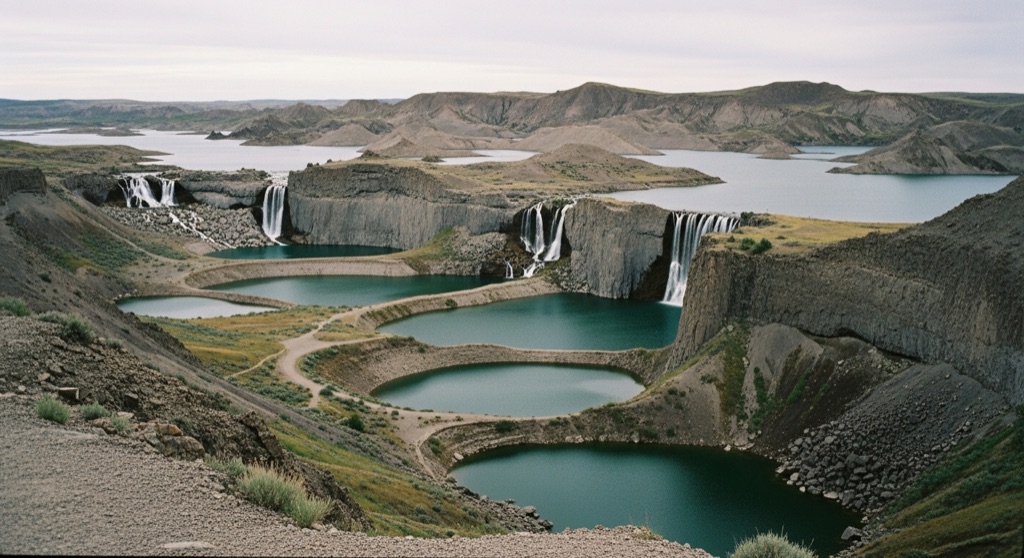
Dry Falls is the ghost of the largest waterfall that ever existed: a 3.5-mile-wide, 400-foot cliff carved by Ice Age megafloods, once roughly four times the size of Niagara, now bone dry and overlooking a chain of plunge-pool lakes. Standing at the overlook in the Channeled Scablands, you are staring at a cataract that hasn't flowed in over 13,000 years. It is one of the strangest geological scenes in the Pacific Northwest.
→ Three more weird outdoor & roadside oddities in Spokane — never the same twice
The story
About 100 miles west of Spokane, Highway 17 cuts across a landscape that looks like an inland sea drained in an instant. Pull off at the overlook in the Channeled Scablands and you are looking directly into the ghost of the largest known waterfall in Earth's history. Over 13,000 years ago, catastrophic Ice Age megafloods burst from glacial Lake Missoula, scouring eastern Washington down to its ancient basalt bedrock. When those wall-of-water floods hit this plateau, they tore out a precipice 3.5 miles wide and 400 feet high—roughly four times the width of Niagara Falls.
Mainstream geology spent decades rejecting the idea that a single series of apocalyptic floods carved this gorge, favoring slow, uniform erosion until the overwhelming physical evidence won out. Standing on the rim today, the sheer scale of the cliff face feels absurdly huge. Directly beneath the dry lip sit a string of still, blue plunge-pool lakes—including Dry Falls Lake and Park Lake—resting in the massive alcoves carved out where millions of cubic feet of rushing water once hammered into the floor.
What it's like
You pull right off Highway 17 onto a high ridge overlooking the entire canyon complex. The air smells of dry sagebrush and sun-baked basalt, and the wind off the scabland plateau is usually stiff enough to pull off your hat. While the historic stone Dry Falls Visitor Center is closed for renovations through late 2026, the overlook railing and the state park grounds remain open. After taking in the high-altitude panorama, you can drive down into the plunge-pool basin near Sun Lakes to hike trails around Umatilla Rock. Bring plenty of water, watch for rattlesnakes along the exposed rocks, and make sure to display a Washington State Discover Pass in your windshield.
The move: Stand at the cliff-edge overlook and try to picture a wall of floodwater four times Niagara, then hike down into the plunge-pool basin.
📍 Before you go The Dry Falls Visitor Center is closed for renovation through the end of 2026, but the overlook and park remain open; a Discover Pass is required.
- 📍 Coulee City, WA
- 💸 Free
- ⚡ Up for anything
- 🌗 Outdoors
Where: 34875 Park Lake Rd NE, Coulee City, WA (Sun Lakes-Dry Falls State Park)
Hours: Added 2026-06-24 — confirm current hours before you go.
Pair it with
- Palouse Falls State Park — Pair this with Palouse Falls to see what an Ice Age megaflood canyon looks like when the river is still actively roaring over the basalt cliff.
- Spokane Astronomical Society Star Parties at Fishtrap — Head southeast into the dark scablands at Fishtrap Lake to look into deep space from the same flood-scoured volcanic bedrock.
- Deep Creek Canyon, Riverside State Park — Trace the path of ancient lava and floodwaters back toward Spokane by scrambling through the dry basalt boulder beds at Deep Creek.
More weird in Spokane

Good to know
Is the Dry Falls Visitor Center currently open?
No. The Dry Falls Visitor Center building is closed for renovations through the end of 2026, but the main outdoor overlook and state park trails remain open to visitors.
Do I need a permit or pass to park at Dry Falls?
Yes. A Washington State Discover Pass is required for parking at the Dry Falls overlook and within Sun Lakes-Dry Falls State Park.
How far is Dry Falls from Spokane?
Dry Falls is located near Coulee City, Washington, roughly 100 miles west of Spokane via U.S. Route 2 and Highway 17.
Plan a visit & invite your people →
Further reading: Wikipedia · parks.wa.gov · nps.gov · Reddit
last checked: 2026-06-24