Entry No. 47 — the San Francisco file — filed under: history
Enriquita Mine
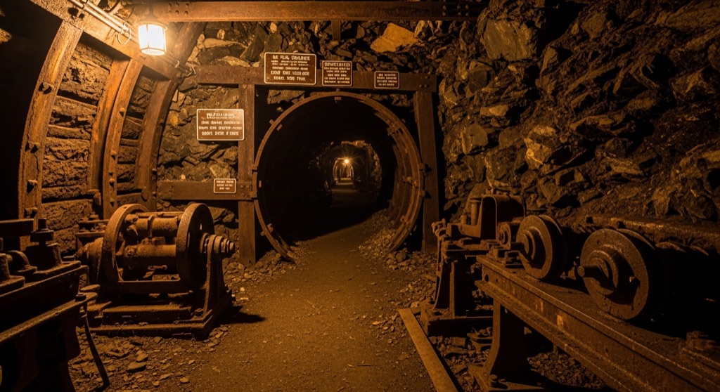
The Enriquita Mine was a historic cinnabar mine established in 1859 as part of the massive New Almaden mercury mining district. Today, the site is preserved within Almaden Quicksilver County Park, where nature has largely reclaimed the hillsides. Visitors hiking the Enriquita Trail can spot rusted remnants of historic mining equipment and sealed tunnel portals.
→ Three at a time, never the same twice — explore weird San Francisco
The story
In 1859, local mine operators celebrated the opening of the Enriquita Mine with enough formal pomp that artist Alexander Edouart was commissioned to paint its Catholic christening. It wasn't just another hole in the ground—it was a key piece of the massive New Almaden mining district, built to extract red cinnabar ore and convert it into quicksilver to refine California’s gold rush yields.
Today, Silicon Valley's suburban sprawl has buried most of the region's early industrial footprint, but the hills above Los Gatos held onto their scars. Preserved inside Almaden Quicksilver County Park, the Enriquita site has been swallowed by oak trees and brush, but the ghosts of the operation remain scattered in plain sight beside the dirt trails.
What it's like
Hiking the Enriquita Trail gives you wide, open views over the Guadalupe Reservoir and out toward the Santa Cruz Mountains, but you're really looking for the iron carcasses rotting in the scrub. Along the path, half-buried gearboxes and rusted industrial debris lie where they were abandoned. You'll eventually come across sealed mine portals—choked off with heavy iron grates and concrete caps. Don't try to bypass them: between deep subterranean drop-offs and residual mercury contamination in the surrounding tailings, staying firmly on the public path is non-negotiable.
The move: Hike the scenic Enriquita Trail to enjoy views of the Guadalupe Reservoir and Santa Cruz Mountains, pausing to safely photograph the rusted historic mining machinery along the path.
📍 Before you go While the surrounding Enriquita Trail is a legally open public hiking path within Almaden Quicksilver County Park, the actual underground mine workings and shafts are sealed and strictly off-limits due to safety hazards and legacy mercury contamination.
- 📍 Los Gatos
- 💸 Free
- ⚡ Low-key
- 🌗 Outdoors
Where: Los Gatos, CA 95032, USA
Hours: Added 2026-07-20 — confirm current access before you go.
Pair it with
- Old Lime Kiln Ruins — Pair two 19th-century industrial ruins in the Santa Cruz Mountains that are being slowly swallowed back into the woods.
- Rosicrucian Egyptian Museum — Trade the toxic quicksilver ruins of the Los Gatos hills for a replica Karnak temple and ancient antiquities down in San Jose.
- Leona Heights Sulfur Mine — Compare two Northern California mining operations that left behind heavy-metal contamination and sealed access shafts.
More weird in San Francisco


Good to know
Can you go inside the Enriquita Mine shafts?
No. All underground portals, tunnels, and adits are permanently sealed off with iron grates and concrete due to collapse hazards and toxic legacy mercury contamination.
Where is the Enriquita Mine located?
The ruin site is located within Almaden Quicksilver County Park near Los Gatos, accessible along the Enriquita Trail.
What was produced at the Enriquita Mine?
It was established in 1859 to mine cinnabar, the primary ore processed to yield quicksilver (liquid mercury).
Is it safe to hike around the old mine site?
Yes, provided you remain on the designated public trail. Off-trail areas contain hazardous mine workings and lingering soil contamination.
Plan a visit & invite your people →
Further reading: westernmininghistory.com · hikingproject.com · onlinelibrary.wiley.com · waterboards.ca.gov
last checked: 2026-07-20