Entry No. 21 — the Raleigh file — filed under: environmental art
Alluvial Decoder
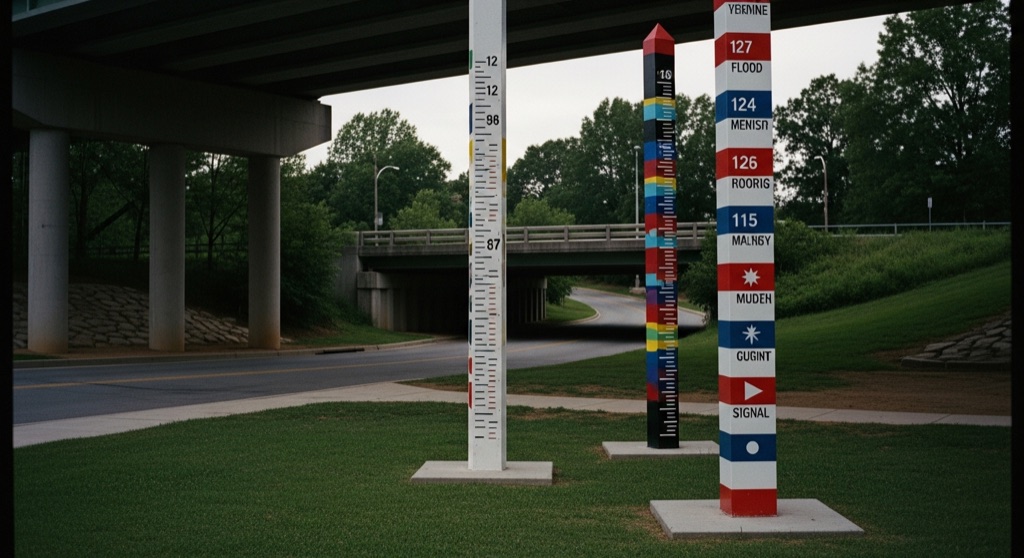
Positioned along Crabtree Creek, this site-specific environmental installation features colorful striped totem poles that mark extreme floodwater heights from major historic hurricanes.
→ Three at a time, never the same twice — explore weird Raleigh
The story
If you walk or bike the Crabtree Creek Greenway near Arrow Drive without looking up, you’ll miss the fact that you're standing beneath decades of catastrophic weather. Artist Lincoln Hancock and the collective A Gang of Three installed Alluvial Decoder right on the bank to translate fifty-plus years of local flood data into something you can measure against your own chest. Towering, brightly striped poles mark the exact water heights reached during historic hurricanes that drowned Midtown Raleigh.
The real secret is painted under the bridge overpass and along the concrete path. Those graphic, geometric patterns aren't just abstract paint jobs—they are maritime signal flags spelling out the names of the specific storms that pushed Crabtree Creek far past its banks. It turns a routine greenway ride into a quiet code-breaking exercise about environmental memory and what urban infrastructure tries to hide.
What it's like
Expect a seamless mix of public greenway and hidden installation art. You'll find the markers situated along the creek bank off 3933 Arrow Dr. The vibe is quiet and slightly utilitarian; commuters bike past while you stand under the 12-foot markers decoding maritime flags beneath the overpass. Visit during dry weather unless you want to slog through creekbank mud, and bring a phone camera to capture the flag patterns for decoding.
The move: Bike along the greenway to stand under the towering 12-foot flood markers, then duck under the bridge overpass to decode the storm names painted in maritime signal flags.
- 📍 Midtown Raleigh
- 💸 Free
- ⚡ Up for anything
- 🌗 Outdoors
Where: 3933 Arrow Dr, Raleigh, NC 27612
Hours: Added 2026-07-21 — confirm current hours before you go.
Pair it with
- Cloud Chamber for the Trees and Sky — Pair two outdoor installations that re-engineer how you experience the landscape—one projecting the sky inside a stone room, the other marking flood levels along a creek.
- Oberlin Cemetery — Continue exploring Raleigh's hidden historical landscape by visiting this 1873 African American cemetery nestled right behind modern office complexes.
- Yayoi Kusama's "Light of Life" — Trade flood-line markers and maritime flag codes for an immersive indoor visual experience at the North Carolina Museum of Art nearby.
More weird in Raleigh
Good to know
How do you read the storm names on the installation?
The painted patterns on the bridge and pavement use the International Code of Signals (maritime flags). Each flag design corresponds to a letter that spells out the names of historic hurricanes.
Is there an admission fee or set operating hours?
No. The installation is part of the public City of Raleigh greenway trail system, so it is free and accessible during standard park hours.
Where is the best place to park or access the site?
Access the Crabtree Creek Greenway trail near 3933 Arrow Dr. You can park at nearby public greenway access lots and walk or ride directly to the overpass area.
Who built the Alluvial Decoder?
The project was designed by artist Lincoln Hancock and the design group A Gang of Three as a site-specific installation and storm memorial in partnership with Raleigh Stormwater.
Plan a visit & invite your people →
Further reading: raleighnc.gov · Atlas Obscura · lincolnhancock.com · indyweek.com · architizer.com
last checked: 2026-07-21