Entry No. 6 — the Pueblo file — filed under: outdoor-weird
Devil's Stairsteps
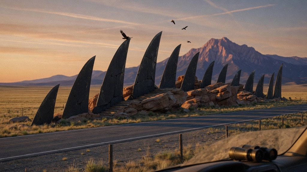
Around 25 million years ago, magma from the West Spanish Peak intrusion shot into cracks radiating through the surrounding sandstone — over 400 of them, like spokes on a wheel. The soft rock eroded; the hard granodiorite fins stayed. The Stairsteps are the showpiece: parallel slabs climbing out of the prairie at a dead-vertical 90 degrees, crossing Highway 12 mid-march. Local legend says the Devil climbed them out of the underworld to survey his takeover before God kicked him back down. Golden eagles and prairie falcons work the wall now.
→ Three more weird outdoor & roadside oddities in Pueblo — never the same twice
The story
Twenty-five million years ago, a massive subterranean intrusion beneath West Spanish Peak blew liquid magma outward into subterranean cracks, radiating through the surrounding sandstone like spokes on a wooden wheel. Over four hundred of these molten veins forced their way through the earth. Over millennia, the soft sandstone surrounding them wore away, leaving the hardened granodiorite cores behind as sharp, knife-like fins standing exposed across the landscape.
The showpiece of this entire system is the Devil's Stairsteps. Here, two parallel slabs of dark rock rise out of the prairie grass at a dead-vertical ninety-degree angle and march straight across Colorado Highway 12. Old regional legend says the Devil himself used these exact giant stone rungs to climb up from the underworld and inspect the territory he intended to seize, right up until God knocked him back down the shaft.
You won't find a visitor center or a ticket booth here—just raw geology slicing right through the asphalt. Today, the thermal drafts sweeping off the sheer vertical stone face are claimed by golden eagles and prairie falcons using the wall as a launching platform to hunt the surrounding flats.
What it's like
You will spot the formation suddenly as you drive Highway 12 six or seven miles south of La Veta. The rock wall marches straight out of the hills and dissects the road. Pull completely into the dirt turnouts directly across from the wall; the highway is narrow, winding, and local drivers carry speed around these bends. The site sits on unmanaged Forest Service land with zero fees, no restrooms, and no designated trails. Keep your feet on the ground—this is strictly a roadside view-and-photograph spot, not a climbing wall. Bring binoculars and sit by the car around golden hour to watch raptors ride the thermal currents rising off the granodiorite.
The move: Drive the Highway of Legends south out of La Veta near golden hour, pull off across from the Stairsteps, and pass the binoculars back and forth counting raptors riding thermals off the wall.
📍 Before you go The dike crosses CO-12 about six to seven miles south of La Veta, midway to Cuchara, and viewing is from roadside pullouts directly across from the wall — the highway is narrow and winding, so park fully off the pavement and watch for fast traffic. The surrounding land is Forest Service with no fees, facilities, or maintained trails, so treat it as a look-and-photograph stop, not a scramble; the formation is fully visible from the car. CO-12 toward Cucharas Pass can be snowpacked in winter. Pair it with Goemmer Butte just west of town, Profile Rock to the east, and lunch in La Veta.
- 📍 La Veta
- 💸 Free
- ⚡ Up for anything
- 🌗 Outdoors
Where: CO Hwy 12 (Highway of Legends), ~6-7 miles south of La Veta, CO 81055
Hours: Added 2026-06-11 — confirm current hours before you go.
Pair it with
- Uptop Ghost Town — After inspecting the 25-million-year-old rock fins, head 12 miles over to this 9,382-foot pass town built in 1877 along the highest railroad tracks on earth.
- FAROUT Murals of Walsenburg — Trade natural vertical stone walls for crumbling brick town walls painted with large-scale murals by artists like Chip Thomas in nearby Walsenburg.
- Walsenburg Mining Museum — Follow the Highway of Legends into Walsenburg to explore the 1896 stone jail that once held labor firebrand 'Mother' Jones during the 1913 coal strikes.
More weird in Pueblo

Good to know
Where are the Devil's Stairsteps located?
They cross CO Highway 12 (the Highway of Legends) about 6 to 7 miles south of La Veta, roughly midway on the drive toward Cuchara.
Are there hiking trails or climbing routes on the wall?
No. There are no maintained trails or developed recreational facilities. The formation is meant to be viewed and photographed from the roadside turnouts.
Are there any fees or parking passes required?
No fees or passes are required. Viewing is free from roadside turnouts on Forest Service land.
What winter driving precautions should I take?
Highway 12 climbs in elevation toward Cucharas Pass and can become snowpacked or icy during winter weather, so check local CDOT road reports before driving out.
Plan a visit & invite your people →
Further reading: coloradobirdingtrail.com · spanishpeakscolorado.com · myscenicdrives.com · spanishpeakscountry.com · codot.gov
last checked: 2026-06-11