Entry No. 50 — the Phoenix file — filed under: history
Maricopa Mine
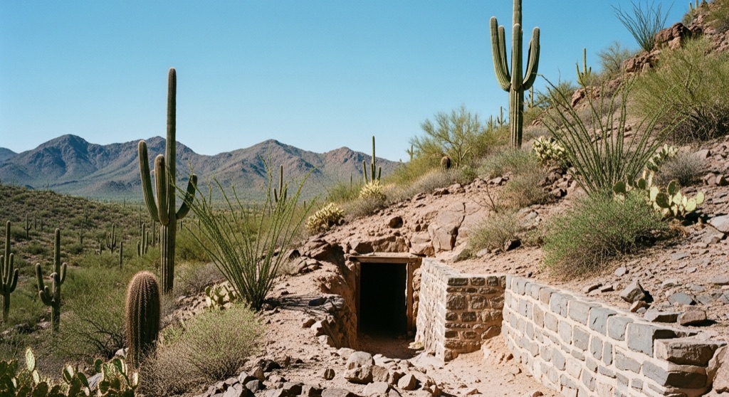
The Maricopa Mine is a historic late-19th-century gold mine located just south of the Jewel of the Creek Preserve in Cave Creek. Active primarily from 1890 to 1910, the site once supported the nearby pioneer townsite of Liscum before its operations ceased. Today, all that remains of the mine is a shallow, ungated adit (tunnel opening) carved into a bluff side along the hiking trails.
→ Three more abandoned & forgotten places in Phoenix — never the same twice
The story
Before Phoenix became an endless sprawl of sunbaked subdivisions, its early politicians were out in the desert rocks hunting for gold. Francis Shaw—who served as Phoenix's second mayor from 1881 to 1883—partnered with a man named McDonald to lay claim to the Maricopa Mine just south of Cave Creek's creekbeds. Between roughly 1890 and 1910, hard-rock miners blasted through the granite bluffs here, pulling up gold ore and feeding the now-vanished pioneer townsite of Liscum.
Today, Liscum has dissolved back into the dirt, but the mine hasn't entirely given up the ghost. What remains is a shallow, ungated adit—a dark tunnel mouth carved straight into the rock face—sitting along the quiet trail system inside the Spur Cross Ranch Conservation Area and Jewel of the Creek Preserve. Saguaro cactuses and desert scrub have spent the last century quietly reclaiming ground once torn open by black-powder dynamite and heavy picks.
What it's like
Hiking the Dragonfly Trail through the riparian greenery of the Jewel of the Creek Preserve feels remarkably calm until you spot the dark, square-cut hole gaping in the bluff side. The opening sits right off the trail, but you didn't hear it from us: resist the urge to duck inside. The unmaintained adit suffers from severe structural instability, and the stagnant air carries toxic dust laced with lead and arsenic. Stay on the marked trail, zoom in with your camera lens for photos, and keep moving before the sun cooks the canyon.
The move: Hike the scenic Dragonfly Trail through the riparian oasis of the Jewel of the Creek Preserve, keeping an eye out for the historic mine adit in the bluff side to photograph from the safety of the trail.
📍 Before you go The mine is located along public hiking trails in the Spur Cross Ranch Conservation Area and Jewel of the Creek Preserve, but entering the ungated adit is highly discouraged due to structural instability and toxic dust containing lead and arsenic.
- 📍 Cave Creek
- 💸 Free
- ⚡ Low-key
- 🌗 Outdoors
Where: Maricopa Mine, Cave Creek, AZ 85331, USA
Hours: Added 2026-07-20 — confirm current access before you go.
Pair it with
- Carefree Sundial — Pair a dusty hike past a 19th-century gold adit with a quick drive to see Carefree's massive 1959 mid-century copper sundial.
- Union Mine — Follow up one defunct gold site with another by heading south to inspect North Phoenix's 75-foot vertical Union Mine shaft.
- Rock Springs Cafe — Cool off after trail-walking through Spur Cross with a slice of pie at this former 1880s stagecoach water stop.
- Deer Valley Petroglyph Preserve — Trade late-19th-century mining ruins for thousands of ancient Hohokam and Patayan rock carvings on nearby basalt boulders.
More weird in Phoenix
Good to know
Where is the Maricopa Mine located?
The mine adit is situated along the Dragonfly Trail within the Jewel of the Creek Preserve and Spur Cross Ranch Conservation Area in Cave Creek, Arizona.
Can you enter the mine tunnel?
No. While the adit is ungated, entering is highly dangerous and strongly discouraged due to structural collapse risks and air heavy with toxic lead and arsenic dust.
Who ran the Maricopa Mine historically?
It was established in the late 19th century by Francis Shaw—former mayor of Phoenix—and his business partner McDonald, operating primarily between 1890 and 1910.
What town was associated with the mine?
The gold mining operations at Maricopa Mine once helped support Liscum, a pioneer settlement that has since completely disappeared.
Plan a visit & invite your people →
Further reading: dflt.org · cavecreekmuseum.org
last checked: 2026-07-20