Entry No. 32 — the Phoenix file — filed under: history
Deer Valley Petroglyph Preserve
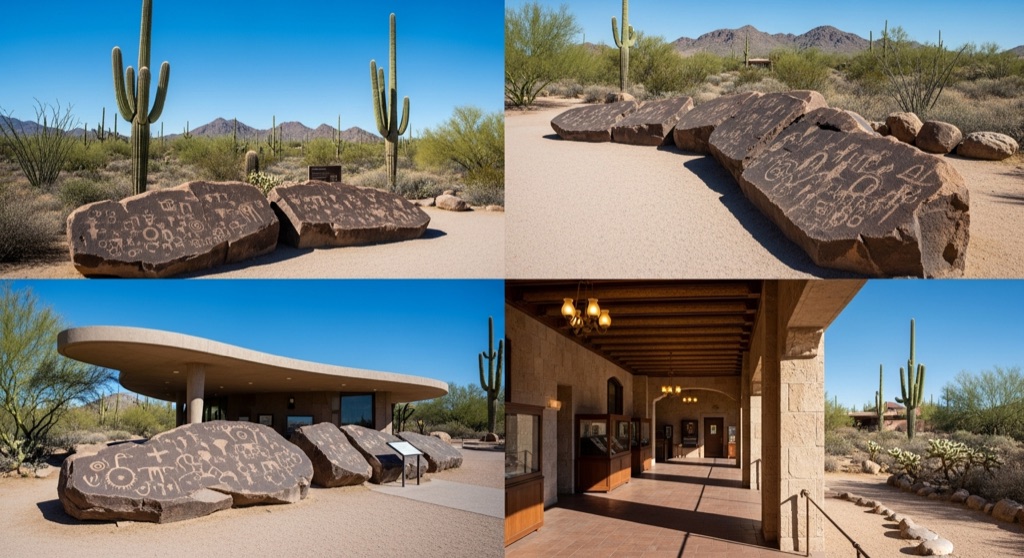
Over 1,500 Hohokam, Patayan, and Archaic petroglyphs — some ~5,000 years old — cover 500 natural basalt boulders along a quarter-mile trail behind a boomerang-shaped museum designed by architect Will Bruder, run by ASU since 1994 on land beside the Adobe Dam flood-control basin north of Phoenix.
→ Three more hidden bars & speakeasies in Phoenix — never the same twice
The story
You wouldn't expect to find five thousand years of human record tucked directly behind a massive flood-control dam and the suburban fringe of North Phoenix. But right at the edge of the Adobe Dam basin sits a boomerang-shaped concrete museum designed by architect Will Bruder, serving as a quiet buffer between modern sprawl and one of the dense concentrations of ancient rock art in the Sonoran Desert.
Behind the building, dark basalt boulders cascade down the ridge of the Hedgpeth Hills. Etched into these sun-baked rocks are over 1,500 individual petroglyphs spread across roughly 500 boulders. The markings span thousands of years of human movement: Archaic hunter-gatherers pecked out abstract designs up to 5,000 years ago, followed centuries later by Hohokam agriculturalists and Patayan travelers who added bighorn sheep, deer, geometric grids, and stylized human figures to the exact same rock faces.
The preserve exists in its current form thanks to an odd piece of bureaucratic luck. When the U.S. Army Corps of Engineers constructed Adobe Dam in 1980, the archaeological significance of the hill led to the land being set aside for protection rather than redeveloped. Arizona State University’s School of Human Evolution and Social Change took over management and opened the museum in 1994, ensuring the carvings remained untouched while suburban subdivisions crept right up to the boundary fence.
What it's like
You'll enter through Will Bruder's low-slung concrete museum before stepping out onto a flat, unpaved quarter-mile trail that loops along the base of the boulder pile. Bring a pair of binoculars or grab a rental at the desk if available—many of the most detailed petroglyphs are pecked high up on the scree slope and easy to miss with the naked eye. Visit early in the morning before heat radiates off the dark basalt. Note that only service animals are permitted on the grounds, and staying strictly on the designated path is enforced to protect the rock faces.
The move: Walk the short self-guided boulder trail spotting figures pecked into the rock centuries apart, then compare notes in the museum on which symbols you each think you decoded correctly.
- 📍 Deer Valley, Phoenix
- 💸 Free
- ⚡ Up for anything
- 🌗 Outdoors
Where: 3711 W Deer Valley Rd, Phoenix, AZ 85308
Hours: Added 2026-07-19 — confirm current hours before you go.
⚠ Seasonal or scheduled — always check before you go.
Pair it with
- Martin Auto Museum and Event Center — Contrast five millennia of static stone etchings with a sprawling indoor stash of 170-plus vintage gas-guzzlers and muscle cars just ten minutes away in Glendale.
- Union Mine — Trade prehistoric rock markings for 19th-century mining history by heading six miles east to check out North Phoenix's historic 1881 gold mine site.
- Fantasia Crystals & School of Magickal Arts (SOMA) — Pair ancient symbolic stonework with a stop at this long-running North Phoenix shop dedicated to herbs, minerals, and contemporary candle magick.
More weird in Phoenix



Good to know
How long is the trail and how long does a visit take?
The self-guided trail is a short quarter-mile loop. Most visitors spend 45 minutes to an hour walking the path and scanning the boulders, plus extra time inside the museum exhibits.
Who carved the petroglyphs?
The rock art was created by three distinct native cultures across thousands of years: Archaic hunter-gatherers (dating as far back as ~3000 BCE), the Hohokam people, and Patayan groups.
Are dogs allowed on the petroglyph trail?
No, pets are not allowed anywhere on the preserve grounds or trail. Certified service animals are the only exception.
Who manages the site?
The preserve is managed by Arizona State University's School of Human Evolution and Social Change on land located beside the U.S. Army Corps of Engineers Adobe Dam flood-control basin.
Plan a visit & invite your people →
Further reading: deervalley.asu.edu · Wikipedia
last checked: 2026-07-19