Entry No. 68 — the Los Angeles file — filed under: ruins
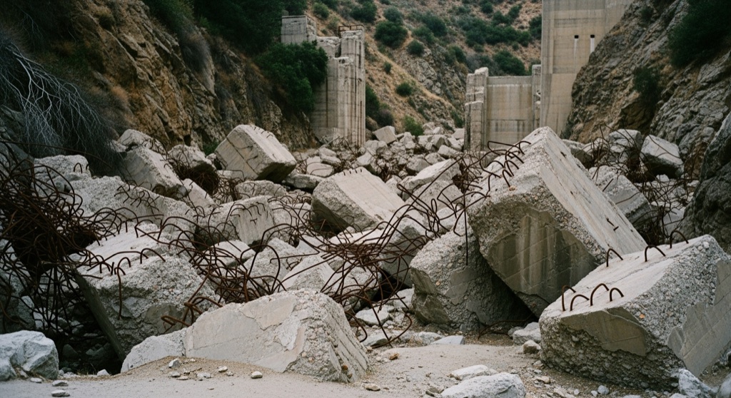
Concrete ruins of the St. Francis Dam
Designed by William Mulholland and completed in 1926, the St. Francis Dam collapsed catastrophically in 1928, unleashing a massive flood that claimed over 400 lives. Today, the site is a designated national monument where visitors can hike to see massive, scattered blocks of concrete and twisted rebar strewn across the canyon floor. The ruins stand as a quiet, somber monument to one of the worst civil engineering disasters in American history.
→ Three more abandoned & forgotten places in Los Angeles — never the same twice
The story
Before Los Angeles became the sprawling metropolis you know today, William Mulholland was busy bending northern California's water supply to the city's will. In 1926, his team completed the St. Francis Dam in San Francisquito Canyon to create a massive reservoir for the Los Angeles Aqueduct system. Just two years later, in March 1928, the entire structure failed catastrophically. A towering wall of water ripped down the canyon, taking more than 400 lives with it in one of the worst civil engineering disasters in American history.
Instead of hauling away the wreckage, the city let nature and time swallow it. What remains today isn't a museum or a manicured memorial—it’s a scattering of monolithic concrete fragments, broken aqueduct piping, and exposed rebar lying right where the torrent left them. Up close, chunks of dam wall the size of two-story houses sit half-buried along the canyon wash, looking like ancient monoliths until you spot the rusted steel grid poking through the concrete aggregate.
What it's like
You’ll trek along the cracked, weed-choked asphalt of abandoned Old San Francisquito Canyon Road, following the wash where the canyon walls open up. The terrain is stark, open, and mostly unshaded, with concrete rubble scattered along the creek bed like tossed dice. It's quiet out here—usually just a few hikers and context-seekers tracing the flow of the flood—so bring plenty of water, wear sturdy shoes for loose canyon rock, and check Angeles National Forest access alerts before heading out.
The move: Take a scenic hike along the abandoned Old San Francisquito Canyon Road to safely view and photograph the colossal concrete ruins scattered along the creek.
📍 Before you go The ruins are located within the Saint Francis Dam Disaster National Monument in the Angeles National Forest, which is legally open to the public for hiking and exploration.
- 📍 Santa Clarita
- 💸 Free
- ⚡ Low-key
- 🌗 Outdoors
Where: Santa Clarita, CA 91390, USA
Hours: Added 2026-07-20 — confirm current access before you go.
Pair it with
- Vasquez Rocks Natural Area Park — Pair the man-made structural destruction in San Francisquito Canyon with the natural, violent tectonic uplifting of 45-degree sandstone slabs just down the road.
- Bear Canyon Mine — Double down on Santa Clarita's hidden canyon ruins by pairing the shattered dam with a hike to an abandoned 1930s gold mine.
- Emma Mine — Keep your high-desert ruin hunt going by heading east toward Acton to explore the relics of a late-19th-century copper and gold mining operation.
More weird in Los Angeles



Good to know
Is it legal to hike around the St. Francis Dam ruins?
Yes. The site sits within the Saint Francis Dam Disaster National Monument inside the Angeles National Forest and is legally open to the public for hiking and exploration.
How do you access the ruins?
You reach the main debris field by hiking along the abandoned section of Old San Francisquito Canyon Road in Santa Clarita, following the canyon floor toward the creek.
When was the dam built and when did it break?
Designed by chief engineer William Mulholland, the dam was completed in 1926 and collapsed suddenly on the night of March 12, 1928.
Plan a visit & invite your people →
Further reading: Wikipedia · archaeology.org · weekendsherpa.com
last checked: 2026-07-20