Entry No. 24 — the Grand Junction file — filed under: outdoor
Valley Curtain Site at Rifle Gap
“Officially, nothing remains. Unofficially: look several hundred feet up the cliffs.”
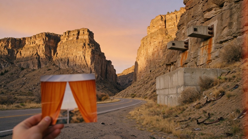
On August 10, 1972, Christo and Jeanne-Claude strung 200,000 square feet of orange nylon across this gap, 1,250 feet wide, sagging over Highway 325 like a held breath. Twenty-eight hours later a gale clocked over 60 mph shredded it. Officially, nothing remains. Unofficially: look several hundred feet up the cliffs and the concrete cable anchors are still bolted to the rock, an oddly shaped retaining wall sits at road level, and the old tie-downs lurk in the grass on the lower slopes.
→ Three more abandoned & forgotten places in Grand Junction — never the same twice
The story
On August 10, 1972, artists Christo and Jeanne-Claude finally succeeded in stringing 200,000 square feet of bright orange woven nylon across Rifle Gap, a 1,250-foot notch where Rifle Creek cuts through the Grand Hogback range. The curtain sagged dramatically across Highway 325, hanging like a giant, suspended wall of orange against the blue Colorado sky.
It didn't last. Twenty-eight hours after the final tie-downs were secured, a high-country gale gusting past 60 miles per hour ripped through the gap and tore the fabric apart. The crew began taking it down immediately. Art history books recorded the project as complete and moved on, leaving an empty horizon above the road.
Officially, the site was restored to its natural state. Unofficially, you don't anchor tens of thousands of pounds of tensioned cable without leaving heavy scars behind. If you pull off the road today and look closely at the cliff faces, the brutalist structural remains of the installation are still bolted directly into the mountain: concrete cable anchors perched hundreds of feet up the rock faces, a distinct concrete retaining wall at road level, and forgotten tie-down pads hiding among the weeds along the lower scree.
What it's like
Drive about seven miles north of Rifle on Highway 325 and pull into the gravel pull-out on the south side of the gap, just before you reach the Rifle Gap Reservoir dam. There are no signs, state park markers, or plaques explaining what happened here; to passing traffic, it’s just another notch in the sandstone. Hand a pair of binoculars back and forth across the front seat and scan the upper cliff walls to spot the industrial concrete anchor blocks embedded in the rock. Skip any urge to climb up the loose scree to reach them—the slopes are slippery, rattlesnakes like the rocks, and the ground-level view with a printed photo of the 1972 curtain held up against the skyline gives you everything you need.
The move: Pull off Highway 325 in the gap, pass binoculars back and forth until you both find the cliff anchors, then hold up a photo of the orange curtain and line it up against the empty sky.
📍 Before you go The gap is on Highway 325 about seven miles north of Rifle, an hour-plus drive from Grand Junction; park at the pull-out near the south end of the gap, just before the Rifle Gap Reservoir dam. The retaining structure is at road level, but the two main cable anchors sit several hundred feet up the canyon walls, so bring binoculars instead of scrambling the loose scree. The smaller concrete tie-downs hide in grass and rocks on the lower slopes and take patience to spot. Pair it with Rifle Falls State Park, five minutes further up the same road.
- 📍 Rifle
- 💸 $$
- ⚡ Up for anything
- 🌗 Indoors
Where: CO Highway 325 at Rifle Gap, ~7 miles north of Rifle, CO 81650 (just south of Rifle Gap Reservoir dam)
Hours: Added 2026-06-11 — confirm current hours before you go.
Pair it with
- Rifle Mountain Park Ice Caves — Drive seven miles further north along Rifle Creek to explore frozen limestone caves carved by the same water network that formed Rifle Gap.
- Powers Art Center — Pair Christo's ghost installation with a permanent, stark red sandstone art museum sitting out in a Carbondale cattle pasture.
- South Canyon Hot Springs — Stop for an unrefined mineral soak in a roadside canyon pool off Highway 6 on your way back toward Glenwood Springs.
More weird in Grand Junction
Good to know
What happened to the original Valley Curtain?
After twenty-eight hours of being fully deployed on August 10, 1972, a windstorm with gusts exceeding 60 mph tore into the gap, forcing Christo and Jeanne-Claude's team to dismantle the shredded installation.
What can you actually see at the Rifle Gap site today?
You can spot the heavy concrete cable anchor points bolted into the upper canyon walls several hundred feet up, a concrete retaining structure at road level, and smaller concrete tie-down blocks buried in the brush along the base of the slopes.
Is there a fee or an official park entrance?
No, the viewing spot is a free public pull-out directly off CO Highway 325, located just south of the Rifle Gap Reservoir dam.
Do I need any special gear to find the anchors?
Bring a decent pair of binoculars or a telephoto lens. The cliff-top anchors sit high up the rock faces and are easy to miss with the naked eye if you don't know where to look.
Plan a visit & invite your people →
Further reading: christojeanneclaude.net · clui.org · coloradocentralmagazine.com · summitdaily.com · postindependent.com · aspendailynews.com
last checked: 2026-06-11