Entry No. 26 — the Fort Collins file — filed under: ghost town
Manhattan Ghost Town & Cemetery
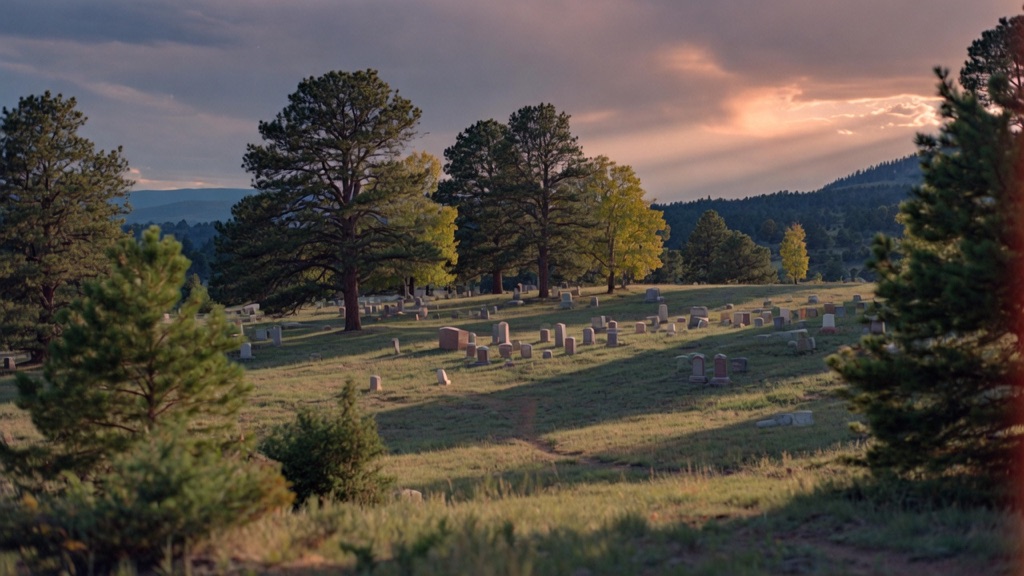
In the 1880s, a gold rush drew hundreds of prospectors to a remote ridge above the Poudre Canyon, and by 1887 a full town called Manhattan had been platted with twenty streets, a hotel, saloon, general store, and a newspaper called the Manhattan Prospector. The three main mines — Laugh-a-lot, Little Tipsy, and Katy's Pet — never hit a mother lode, and by 1900 the post office had closed. The Forest Service dismantled the last remaining structures in the 1930s as fire hazards. Today almost nothing is visible except faint cabin-foundation depressions hidden in the grass and, on the hillside, a small cemetery dating to 1892 — including two graves of miners killed in the Black Hawk mine explosion of November 1892. The site sits at 8,474 feet, 45 miles west of Fort Collins.
→ Three more hidden bars & speakeasies in Fort Collins — never the same twice
The story
In 1886, gold fever hit a high ridge 8,474 feet above the Cache la Poudre Canyon, and by 1887 optimistic promoters had mapped out a twenty-street grid on paper and named it Manhattan. For a brief moment, this remote patch of forest boasted a hotel, a saloon, a general store, and a local newspaper called the Manhattan Prospector. Prospectors staked claims with wildly ambitious names—Laugh-a-lot, Little Tipsy, and Katy's Pet—convinced they were sitting on top of the region's next great mother lode.
The pay dirt never materialized. The surface veins fizzled out almost immediately, and by 1900 the post office shut down, leaving the town to collapse back into the weeds. In the 1930s, the U.S. Forest Service swept through and burned or dismantled the last remaining rotting log cabins to mitigate wildfire danger, effectively erasing Manhattan's physical footprint from the ridge.
What remains today is an exercise in reading the ground carefully. If you know where to look, you can spot faint, rectangular depressions in the grass where cabin foundations used to sit. Higher up on the hillside sits the real anchor: a small 1892 cemetery, where weathered headstones still mark the final resting place of early locals—including two miners killed in the November 1892 Black Hawk mine explosion. The 2020 Cameron Peak Fire burned heavily through this corridor, leaving standing dead pine and opening wide, exposed views across the forgotten townsite.
What it's like
Reaching the townsite requires navigating County Road 68C north of Rustic, an unpaved stretch of washboard dirt, loose rock, and deep ruts where a high-clearance vehicle is strongly advised. There is no cell service, no park visitor center, and no official historical highway sign pointing the way, so you will need GPS coordinates (40.7322°N, 105.6000°W) locked into offline maps before you lose signal in Poudre Canyon. Expect quiet, windswept high-country stillness where you'll have to hunt through the meadow grass for foundation dips before trekking up to the hillside cemetery markers. Bring your own food, water, and warm layers—there are no services whatsoever once you turn off the main road.
The move: Drive out through Poudre Canyon or up Red Feather Lakes Road in late summer, walk the quiet meadow where twenty platted streets once ran, and sit together at the 1892 cemetery reading the weathered markers. Bring a picnic — there is nothing else for miles.
📍 Before you go High-clearance vehicle strongly recommended; roads are unpaved and rough, especially after rain. No services, cell signal, or signage once you leave the main roads — download offline maps or note GPS coordinates before leaving. Best visited late May through October; roads can be snow-blocked or muddy in shoulder seasons. The townsite is on or near National Forest land but portions may border private property; stay on the road corridor. Cameron Peak Fire burned through the area in 2020, so expect altered tree cover.
- 📍 Red Feather Lakes
- 💸 $$
- ⚡ Up for anything
- 🌗 Indoors
Where: County Road 68C/162, approximately 4 miles north of Rustic, Larimer County, CO (near 40.7322°N, 105.6000°W)
Hours: Added 2026-06-11 — confirm current hours before you go.
⚠ Seasonal or scheduled — always check before you go.
Pair it with
- Great Stupa of Dharmakaya — Pair a quiet walk through Manhattan's 1892 pioneer cemetery with a visit to North America's tallest stupa, sitting just down the road in the same Red Feather backcountry.
- Gnome Road (Elf Lane) — Trade 1880s mining history for modern roadside absurdity by taking the nearby dirt roads into Red Feather Lakes to hunt for hidden forest gnomes.
- Deadman Fire Lookout Tower — Continue driving deeper into Roosevelt National Forest to reach this active 10,710-foot fire lookout tower for panoramic views over the surrounding burned timber and high peaks.
More weird in Fort Collins

Good to know
Are there any standing ghost town buildings left to see?
No. The U.S. Forest Service dismantled all remaining wooden structures during the 1930s as fire hazards. You are looking for subtle rectangular earthwork depressions in the meadow and the 1892 hillside cemetery.
What kind of vehicle do I need to get there?
A high-clearance vehicle is strongly recommended. The dirt backroads (County Road 68C/162) are rough and unpaved, turning muddy and rutted after rainstorms and impassable due to snowpack outside late May through October.
Is Manhattan Ghost Town on public land?
The townsite sits on or near Roosevelt National Forest land, but surrounding parcels in the Red Feather Lakes region border private property. Stick to the public road corridor and established National Forest land to avoid trespassing.
Who is buried in the Manhattan cemetery?
The hillside cemetery dates back to 1892 and contains graves of early settlers and miners, including two men who were killed in a tragic explosion at the nearby Black Hawk mine in November 1892.
Plan a visit & invite your people →
Further reading: Wikipedia · northfortynews.com · Official site · latitude.to · reporterherald.com · Reddit
last checked: 2026-06-11