Entry No. 37 — the Fort Collins file — filed under: wwii-history
Crown Point B-17 Crash Site
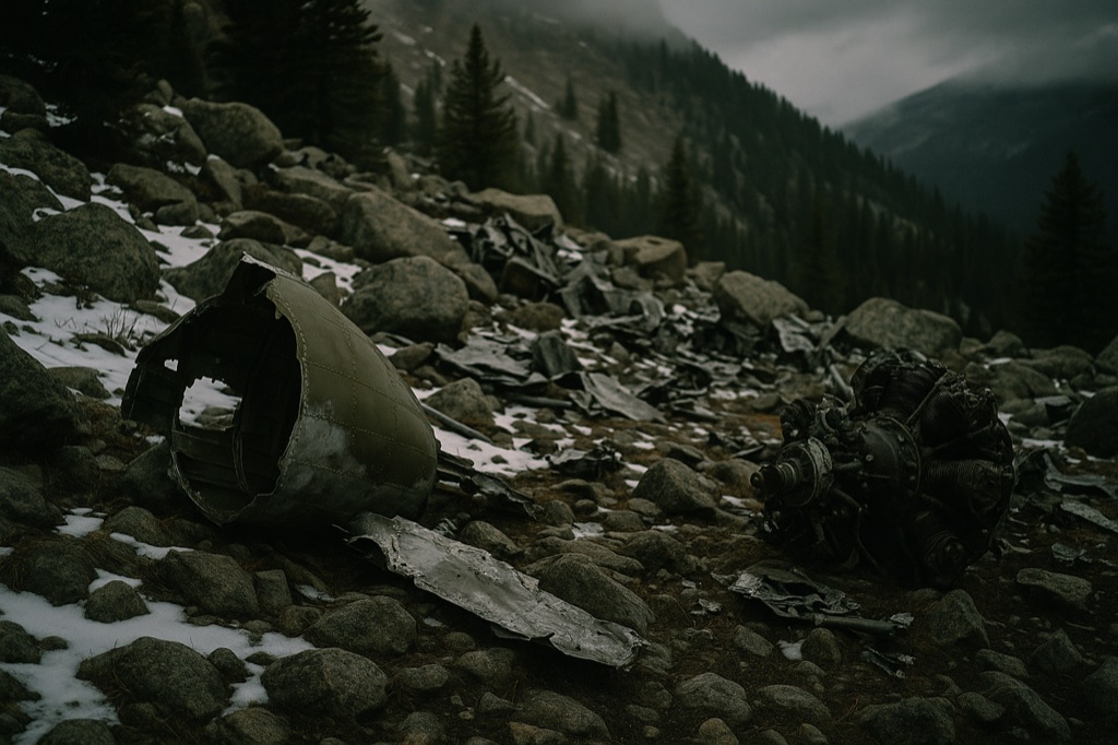
On June 13, 1944, a fully crewed Army Air Forces B-17 slammed into a snow-covered mountainside north of Crown Point and killed four of its ten men — pilot Drury Holt among them — in a place locals still call Hell's Half Acre. Nearly 80 years later the wreckage is still there: shredded fuselage panels, mangled engine components, and bomber fragments scattered across a boulder field at around 11,000 feet. Green metal tags nailed to trees are the only navigation aid on the final approach, which the trail guides charitably describe as a treasure hunt. Six men walked away from this; standing in the debris field, that fact is somehow the most unsettling part.
→ Three more weird outdoor & roadside oddities in Fort Collins — never the same twice
The story
On June 13, 1944, an Army Air Forces B-17 Flying Fortress carrying ten men went down hard on a snow-strewn mountain ridge north of Crown Point. Pilot Drury Holt and three crew members died on impact in a steep draw locals called Hell's Half Acre. What stops you cold when you stand in the debris field today isn't just the memory of the dead—it's the six men who somehow pulled themselves out of the shredded fuselage at 11,000 feet and walked away.
The military retrieved sensitive gear after the crash, but hauling a multi-ton four-engine bomber off an isolated timberline slope in 1944 was out of the question. So they left it. Eight decades later, thin alpine air and high-country snow pack have kept the wreck in eerie stasis: mangled wing skinning, radial engine components, heavy structural ribbing, and severed cables lie scattered across boulder fields and pine needles. The forest has slowly grown around the aluminum, leaving a raw WWII ruin without museum glass or official plaques.
What it's like
Reaching the site means driving up Poudre Canyon via Highway 14 and rattling down the dirt of Pingree Park Road to the Stormy Peaks Trailhead. The hike runs about nine kilometers round-trip with roughly 370 meters of climbing, but standard trail markers disappear on the final stretch. You'll be scanning timber trunks for weathered green metal tags while picking your way through deadfall and burn scars left by the 2020 Cameron Peak Fire. Download offline map tracks before leaving Fort Collins—cell coverage disappears miles down the canyon, and the unmaintained scramble across the boulder field demands accurate navigation.
The move: Drive Pingree Park Road to the Stormy Peaks Trailhead, hike roughly 3 miles through Roosevelt National Forest following the green tree tags, and spend time in the boulder-strewn debris field before heading back.
📍 Before you go Trailhead is at the end of Pingree Park Road (Stormy Peaks Trailhead, approx. 40.5705, -105.5885). Trail is ~9 km round-trip with ~370 m elevation gain; terrain is forested with a primitive, poorly-signed final approach — bring GPS. Recommended window is May through October; road and trail can be snow-covered outside that window. No permit required; dogs on leash allowed.
- 📍 Bellvue
- 💸 Free
- ⚡ Up for anything
- 🌗 Outdoors
Hours: Added 2026-06-21 — confirm current hours before you go.
⚠ Seasonal or scheduled — always check before you go.
Pair it with
- Mishawaka Amphitheatre — Stop along the Poudre Canyon on your drive back down Highway 14 for food and a drink on the river deck.
- Manhattan Ghost Town & Cemetery — Pair this mountain wreckage hike with a trip to an 1880s mining town cemetery hidden in nearby Red Feather Lakes.
- Great Stupa of Dharmakaya — Contrast the rugged military crash site in Comanche Peak Wilderness with a quiet, 108-foot monument set deep in the mountain pines.
More weird in Fort Collins


Good to know
How difficult is the hike to the B-17 wreckage?
The route is roughly 9 kilometers (5.5 miles) round-trip with about 370 meters of elevation gain. While the physical climb is moderate, navigation is challenging because the final approach follows unmarked terrain and primitive tree tags.
Where do I park to start the hike?
Park at the Stormy Peaks Trailhead located at the end of Pingree Park Road in Roosevelt National Forest, roughly an hour and 45 minutes west of Fort Collins.
Am I allowed to keep pieces of the plane?
No. Federal laws protect historic artifacts and military crash remains on public land. Taking scrap, metal, or debris from the site is illegal.
What months are best for visiting?
May through October is the workable window. Outside of late spring and early autumn, heavy snow buries Pingree Park Road, the trail, and the debris field.
Plan a visit & invite your people →
Further reading: denver7.com · 10adventures.com · history.fcgov.com · gazette.com · cmc.org · ouachitamaps.com
last checked: 2026-06-21