Entry No. 48 — the Colorado Springs file — filed under: outdoor
Heizer Trail to Cascade Mountain
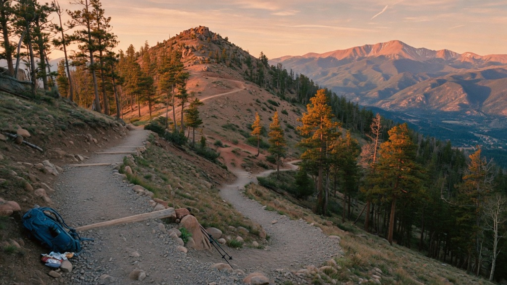
Everyone in this town hikes Barr Trail, then complains about the crowds. Almost nobody walks the Heizer — a steep, lightly trafficked cut that the president of the Cascade Town Co. carved up the mountain back in the 1880s, making it one of the oldest surviving trails in the Pikes Peak region. It climbs without apology through wooded switchbacks and loose gravel toward the 9,387-ft summit of Cascade Mountain, where the trees finally let go and you get the whole show: Pikes Peak, Ute Pass dropping away below, the Front Range, and ranges stacked to the horizon. It is a real climb. The view is the kind you have to earn, which is exactly why so few people have it.
→ Three more weird outdoor & roadside oddities in Colorado Springs — never the same twice
The story
While tourists bottleneck on the Manitou Incline or crawl up Barr Trail shoulder-to-shoulder, the Heizer Trail sits hidden behind a quiet dead-end neighborhood in Cascade. Carved in the 1880s by the president of the Cascade Town Company, it stands as one of the oldest surviving routes in the Pikes Peak region. You won't find park rangers or water stations here—just an uncompromising 19th-century cut carved straight up the mountain.
The trail wastes no time on gentle warm-ups. Step off the pavement and you're instantly locked into roughly 15 sharp switchbacks cutting through Douglas fir and ponderosa pine before opening into scrubby Gambel oak. Mid-ascent, the grade steepens to over 20 percent, coated in loose, marble-sized Pikes Peak granite scree that rolls underfoot like tiny ball bearings. You gain over 1,800 vertical feet in under two miles, with views dropping straight down Ute Pass.
Reaching the 9,387-foot summit opens up a wide panorama across the Front Range and directly into Pikes Peak's eastern flank. If you decide to push past the summit toward Manitou Reservoir, know your boundaries: the reservoir is a closed municipal watershed, meaning the shoreline is strictly off-limits. Turn around at the summit ridge, take in the panorama, and start the descent before afternoon lightning rolls over the peak.
What it's like
Arrival requires strictly respecting local parking rules: parking on Anemone Hill Road or at the actual trailhead is forbidden and enforced, so pull off along Emporia Avenue or Park Street and walk up the road. The ascent is continuous from step one, shifting from shady pine forest to exposed scree slopes where trekking poles are almost mandatory to save your knees on the way down. Pack plenty of water, wear stiff-soled shoes for the rolling gravel, and hit the trail early to avoid mid-day heat and summer afternoon thunderstorms.
The move: Make the climb itself the date. Hit the trail early, settle into the rhythm of switchbacks together, and let the conversation go where a long uphill takes it — there's nowhere to hide on a 2,000-foot grind, which is the whole point. Pack water, snacks, and a layer you don't think you'll need, and time it so you summit with the panorama wide open. Trade the energy bar at the top, take the obligatory two-of-you-against-Pikes-Peak photo, and walk back down knowing you found out something real about each other on the way up.
📍 Before you go A serious, lesser-known alternative to the packed Barr Trail. Figure roughly 5.7-6.3 miles out-and-back to the Cascade Mountain summit (9,387 ft) with about 1,840 ft of climbing; push on toward Manitou Reservoir and it stretches to ~7 miles and 2,400+ ft of gain. Rated moderate-to-difficult (a black-diamond grind) — steep wooded switchbacks, loose gravel, grades up to ~24%, so good shoes and water are non-negotiable. Trailhead sits in Cascade off US 24 (~25-35 min from Colorado Springs); there's no trailhead parking, so park on Emporia Ave or Park St and walk up Anemone Hill Rd. Open year-round, but it's high and exposed near the top: expect snow and ice fall through spring, watch for fast afternoon thunderstorms in summer (be off the summit by early afternoon), and respect the altitude. Late spring through fall is the sweet spot. No fee or permit for the trail itself — but Manitou Reservoir is closed city watershed, so the lakeshore is off-limits; turn around at the summit. Conditions and access can change, so check a current trail report before you go.
- 📍 Cascade / Manitou backcountry, off US 24 west of Manitou Springs
- 💸 Free
- ⚡ Up for anything
- 🌗 Outdoors
Where: Heizer Trailhead at the end of Anemone Hill Rd, Cascade, CO. From Colorado Springs/Manitou Springs take US 24 west about 5 miles to Cascade, turn left at the traffic light onto Fountain Ave, then left on Emporia Ave, left on Park St, and left up Anemone Hill Rd to the trail. Note: there is NO parking at the trailhead or on Anemone Hill Rd — park along Emporia Ave or Park St and walk in.
Hours: Day-use, free. Best season: Late spring through fall (June-October); year-round but expect snow/ice near the summit in winter and early spring. Confirm trail & road conditions before you go.
⚠ Seasonal or scheduled — always check before you go.
Pair it with
- Penny Arcade — After grinding out nearly 2,000 feet of mountain vert on loose dirt, drop down into Manitou Springs to rehydrate and trade mountain trails for century-old mechanical games.
- Red Mountain — If you prefer steep, unsung climbs that bypass the tourist circus of the Manitou Incline, double down on this quiet peak sitting right across the canyon.
- Haunted Lantern Tour at Cave of the Winds — Trade the high-elevation skyline views of Cascade Mountain for subterranean limestone passages lit only by hand-held oil lamps.
- Iron Springs Chateau Melodrama — Pair an unforgiving wilderness workout with classic Victorian melodrama staged directly over a capped historic mineral spring.
More weird in Colorado Springs
Good to know
Where do I park for the Heizer Trail?
Park on Emporia Avenue or Park Street in Cascade and walk up Anemone Hill Road. There is zero parking permitted at the trailhead or along Anemone Hill Road.
How steep and difficult is the hike?
It is a black-diamond level hike, gaining about 1,840 vertical feet over 1.6 to 2 miles to the 9,387-foot summit, with trail grades reaching up to 24% on loose granite gravel.
Can I go down to the shore of Manitou Reservoir?
No. While the trail connects toward Manitou Reservoir, the lake and shoreline are protected city watershed property and off-limits to visitors.
Is there a fee or permit required to hike?
No, the trail is free and open for public day use year-round without permits, though winter and early spring bring snow and ice near the summit.
Plan a visit & invite your people →
Further reading: manitousprings.org · hikingproject.com · Official site · visitcos.com · Reddit
last checked: 2026-06-10