Entry No. 39 — the Boulder file — filed under: mosaic
The Clarifier Project
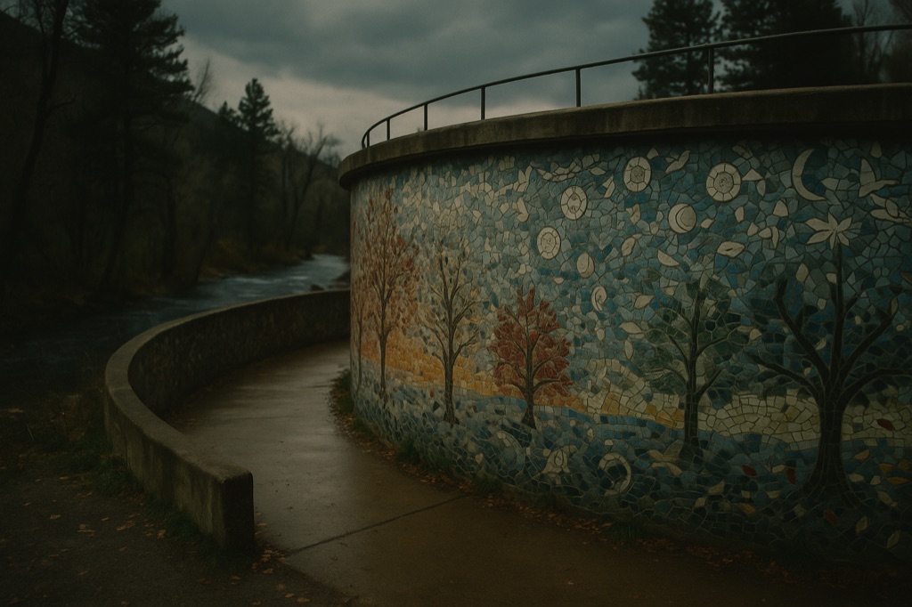
A 1950s cement wastewater treatment tank in Lyons got 60,000 hand-painted tiles pressed into its 96-foot concrete circumference by 325 volunteers over eleven years — and it still isn't done messing with you, because GPS can't reliably find it. Walk the full ring and you'll pick out four seasons rendered in Lyons redstone trees, thirteen Front Range bird species, zodiac symbols, and ceramic leaves made by local kids, all grouted together with 800 pounds of grout and finished two years after the 2013 flood nearly ended the whole thing. The park sits right along the St. Vrain, which makes the flood backstory land differently when you're standing inside it.
→ Three at a time, never the same twice — explore weird Boulder
The story
Before 1950, residents in Lyons relied on backyard outhouses. That changed when the town built a circular cement wastewater treatment tank along the river—a purely functional 1950s municipal clarifier. Decades after the plant was decommissioned, artists Candace Shepard, Cathy Rivers, and Priscilla Cohan didn't see an obsolete concrete ruin; they saw a 96-foot circumference waiting for an intervention. Over eleven years, 325 local volunteers hauled 450 buckets of water, mixed 800 pounds of grout, and pressed roughly 60,000 tiles into the tank's surface.
Walk the full 360-degree ring and the structure reveals a detailed visual narrative. Four Lyons redstone trees mark the cardinal directions, capturing the Front Range across the four seasons. Ceramic leaves hand-molded by local school kids line the branches, glass-mosaic birds fly clockwise around the upper perimeter, and zodiac medallions map the celestial seasons above. Look closely into the matrix between tiles and you'll spot personal items donated by locals—broken heirloom porcelain, a lipstick tube, a doll's head, and blown-glass paperweights embedded directly into the concrete.
In September 2013, the surrounding St. Vrain River crested in a historic, catastrophic flood that tore through Lyons. While the disaster nearly derailed the project, the heavy concrete tank held firm against the current. When work resumed, the artists adapted the design to document what happened: a tile on the north face marks the flood's high-water line, while a ring of concentric blue hearts in the eastern sky mosaic honors displaced neighbors. The project was finally completed and dedicated in 2015, turning a piece of raw municipal sewage infrastructure into a permanent monument to town survival.
What it's like
Don't count on phone GPS to drop you at the precise spot—mapping apps consistently get confused along this stretch of the riverbank. Park near 39 E. Main Street, head toward the St. Vrain River, and take the flat gravel trail into the riverside park until the tiled cylinder appears. There are no gates, fees, or ticket takers. The vibe is slow and unpretentious; you're as likely to share the path with someone walking a dog as you are with an art seeker doing a slow 360-degree lap searching for the 2013 flood marker and the embedded lipstick tube.
The move: Drive up to Lyons, park near Main Street, then follow the river path until you find the tank and walk the full 360° ring together.
📍 Before you go The tank sits in a riverside park; GPS navigation is unreliable — park near Main Street and walk toward the St. Vrain River. Terrain is flat gravel path. No gate or fee.
- 📍 Lyons
- 💸 $$
- ⚡ Up for anything
- 🌗 Indoors
Where: 39 E. Main St., Lyons, CO
Hours: Added 2026-06-21 — confirm current hours before you go.
⚠ Seasonal or scheduled — always check before you go.
Pair it with
- Lyons Classic Pinball — Trade quiet, hand-grouted riverside folk art for tactile, noisy mechanical game physics just a short walk away on Main Street.
- Lyons Classic Video — Follow up an open-air concrete mosaic tour with a dive into Oskar Blues' basement for a dark, free-entry cave of 1980s black-light arcade machines.
- WeeCasa Tiny House Resort — Located 0.3 miles away, this tiny house enclave sits directly on the floodplain land rebuilt after the exact same 2013 St. Vrain flood commemorated on the Clarifier's walls.
More weird in Boulder



Good to know
How much does it cost to visit, and what are the hours?
It is completely free with no gate or fee. It sits in a public park along the St. Vrain River, accessible via a gravel path.
Why can't GPS find the location?
The tank is situated off the road in a riverside park along the St. Vrain, which confuses standard street-address navigation. Park near Main Street and walk toward the river path on foot.
What hidden objects should I look for in the mosaic?
Keep an eye out for a high-water mark tile from the 2013 flood on the north face, a constellation of blue hearts in the eastern sky, student-crafted clay leaves, and odd embedded personal objects like a lipstick tube, a doll's head, and glass paperweights.
Is the path accessible for visitors with limited mobility?
The park path leading from the street to the tank is flat gravel, making for a smooth, flat walk around the entire structure.
Plan a visit & invite your people →
Further reading: bouldercountyarts.org · pearlmoonplenty.wordpress.com
last checked: 2026-06-21