Entry No. 37 — the Washington, D.C. file — filed under: weird monument
Zero Milestone
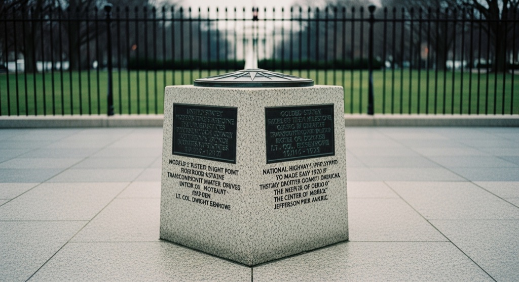
A squat 2-foot-square granite block just south of the White House is, officially, the intended starting point for measuring every road distance in the United States — modeled on Rome's Golden Milestone, topped with a bronze 16-point compass rose, and carved with dedications to two 1919-1920 transcontinental military motor convoys (one of them driven by a young Lt. Col. Dwight Eisenhower). The national highway-marker system it was supposed to anchor never actually got built out around it.
→ Three more weird outdoor & roadside oddities in Washington, D.C. — never the same twice
The story
In June 1919, a good-roads advocate named Dr. S.M. Johnson pitched a grandiose vision to the U.S. Army: plant an American answer to Rome's Golden Milestone—the Milliarium Aureum—right on the south lawn of the White House grounds. It was meant to serve as the literal mile zero for every highway and paved road constructed across the United States, radiating outward from Washington like spokes on a wheel.
To prove how desperately the nation needed decent roads, the Army launched its First Transcontinental Motor Convoy out of this exact patch of turf later that year. A young Lieutenant Colonel named Dwight D. Eisenhower tagged along, enduring two months of bogged-down trucks, collapsing bridges, and unpaved mud tracks across the continent. That grueling road trip stuck with Eisenhower all the way to the Oval Office, where he signed the Interstate Highway Act of 1956.
The four-foot granite block was dedicated in 1923, complete with a bronze 16-point compass rose on top and carved dedications to the 1919 and 1920 military convoys. But the grand bureaucratic plan fell apart almost immediately: state road authorities and federal planners opted to measure highway distances locally instead. The stone stands today as a monument to an official center point that nobody actually measures from.
What it's like
You'll find the squat granite marker standing just inside the northern curve of the Ellipse, directly aligned with the south face of the White House. Thousands of tourists walk right past it every day to snap White House photos without ever glancing down at their knees. Walk right up, check out the bronze compass rose on top, and look for the U.S. Coast and Geodetic Survey brass plate. If you want to make a game of forgotten geographic anchors, walk five minutes south across the Mall to hunt down the Jefferson Pier—another near-miss attempt to fix the center of the country.
The move: Add it to a Ellipse loop walk — it's easy to step right past it, so make a game of spotting it near the White House fence, then compare notes on how many zeros of 'the center of America' you can find nearby (the not-quite-matching Jefferson Pier is a five-minute walk away on the Mall).
- 📍 President's Park / The Ellipse
- 💸 Free
- ⚡ Up for anything
- 🌗 Outdoors
Where: The Ellipse, near 15th St NW and Constitution Ave NW, Washington, DC 20500
Hours: Added 2026-07-19 — confirm current hours before you go.
Pair it with
- Clara Barton Missing Soldiers Office Museum — Pair one ignored federal landmark with another by walking east to the preserved third-floor boarding house room where Clara Barton traced missing Civil War soldiers.
- The Mirror — After standing at the official zero-point of America's highways, walk six blocks north to slip through a wall-mounted mirror into a hidden basement cocktail bar.
- Waldorf Astoria Washington DC — Himalayan Salt Therapy Room — Head ten minutes east down Constitution Avenue to follow up your outdoor monument walk with a salt therapy session inside the landmark Old Post Office building.
More weird in Washington, D.C.

Good to know
Are U.S. highway distances actually measured from this spot?
No. Although Dr. S.M. Johnson conceived it as the origin point for all American highways, federal and state road authorities ultimately calculated mileage locally within individual states and along specific highway corridors.
What is carved into the granite monument?
The sides of the block feature carved inscriptions commemorating the U.S. Army's 1919 and 1920 transcontinental motor convoys, which proved the urgent need for a paved national road network.
What sits on top of the block?
The top holds a bronze 16-point compass rose, accompanied by geographic survey coordinates recorded by the U.S. Coast and Geodetic Survey.
Is the Zero Milestone open to visit anytime?
Yes. It stands in open public parkland on the Ellipse inside President's Park and can be visited freely without tickets or security checkpoints.
Plan a visit & invite your people →
Further reading: Wikipedia · fhwa.dot.gov · nps.gov · boundarystones.weta.org
last checked: 2026-07-19