Entry No. 60 — the Seattle file — filed under: ruins
Abandoned Clay Pit
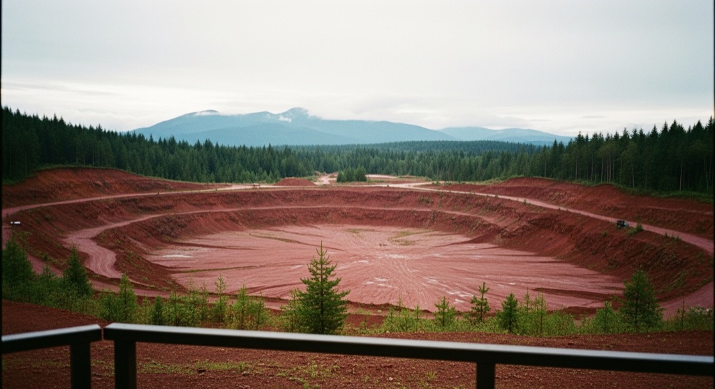
Located within Cougar Mountain Regional Wildland Park, this massive open-cut mine was operated by Mutual Materials from the late 1950s until the 2008 recession. It supplied raw clay to the Newcastle brick plant, producing the bricks used to build the University of Washington's Red Square and T-Mobile Park. Today, the pit has been graded and seeded as a meadow, leaving a vast, red-tinted clay depression surrounded by regrowing forest.
→ Three more abandoned & forgotten places in Seattle — never the same twice
The story
Next time you walk across the vast brick expanse of UW’s Red Square or step onto the concourse at T-Mobile Park, remember that the raw earth beneath those bricks came from this hidden corner of Renton. From the late 1950s until the 2008 recession shut down operations, Mutual Materials ran a massive open-cut clay mine on Cougar Mountain, digging out raw material and hauling it off to the Newcastle brick plant to build Seattle's recognizable landmarks.
When the machinery went silent, King County didn't cover up the scar. The open pit was graded and seeded as a meadow, leaving an eerie, rust-red depression framed by regrowing Pacific Northwest forest. It remains one of the stranger pockets in the regional park system—a stark industrial pit mid-transformation, slowly being swallowed back up by nature.
What it's like
Set out from the Sky Country Trailhead along the wide, gravel track of Clay Pit Road. The gentle trek leads straight to an overlook along the pit's rim, offering a stark view across the red-tinted basin toward Tiger Mountain in the distance. Pay attention to the signage: the actual floor of the pit is a protected habitat restoration zone clearly marked as 'no public access' on park maps, so enjoy the bizarre crimson terrain from the trail edge rather than scrambling down into the clay.
The move: Hike along the wide, gravel Clay Pit Road from the Sky Country Trailhead to the overlook at the edge of the pit, where you can enjoy views of the red clay landscape and Tiger Mountain.
📍 Before you go While the Clay Pit Road trail leads directly to the edge of the pit, the actual floor of the clay pit is a protected habitat restoration area and is marked as 'no public access' on park maps.
- 📍 Renton
- 💸 Free
- ⚡ Low-key
- 🌗 Outdoors
Where: Renton, WA 98059, USA
Hours: Added 2026-07-20 — confirm current access before you go.
Pair it with
- Ford Slope Mine — Stay on Cougar Mountain to explore another relic of the ridge's industrial mining history, where coal shafts once reached 1,500 feet underground.
- Dairy Barn Ruins — Head to Mercer Island for another quiet trek to decaying mid-century infrastructure hidden within a public park.
- Bill Speidel's Underground Tour — Head into Pioneer Square to walk among the subterranean brick storefronts built during Seattle's post-fire reconstruction era.
More weird in Seattle
Good to know
How do you reach the Abandoned Clay Pit?
Park at the Sky Country Trailhead inside Cougar Mountain Regional Wildland Park and hike along the gravel Clay Pit Road directly to the overlook at the pit's edge.
Can you walk down into the bottom of the pit?
No. The floor of the clay pit is designated as a protected habitat restoration area and is marked as 'no public access' on official park maps.
What was the clay from this mine used for?
Clay extracted here was processed at the nearby Newcastle brick plant to produce the bricks used to pave the University of Washington's Red Square and construct T-Mobile Park.
When did the clay pit stop operating?
Mutual Materials operated the mine from the late 1950s until it was closed down during the 2008 recession.
Plan a visit & invite your people →
Further reading: Wikipedia · rentonreporter.com
last checked: 2026-07-20