Entry No. 18 — the Milwaukee file — filed under: history
American Geographical Society Library
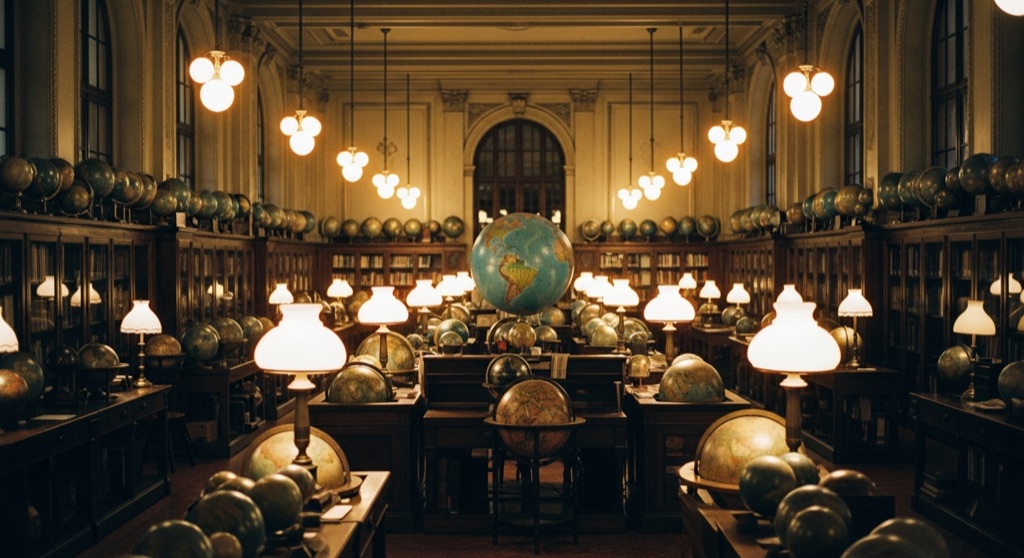
Tucked inside UW-Milwaukee's Golda Meir Library is an archive containing nearly two million maps, globes, and cartographic artifacts gathered since the 1850s. Displays include celestial maps, rare nautical charts, and FDR’s 50-inch, 700-pound WWII 'President's Globe'.
→ Three at a time, never the same twice — explore weird Milwaukee
The story
Most people walking through the Golda Meir Library on UWM's campus assume they are just passing study desks and computer labs. They don't realize that in 1978, one of the greatest cartographic stashes in the Western Hemisphere was quietly uprooted from New York City and transplanted right here to Milwaukee's Upper East Side. The American Geographical Society had been hoarding maps, sea charts, and globes since the 1850s, and when the archive moved west, it brought nearly two million cartographic artifacts along with it.
The crown jewel sitting in the gallery is FDR’s World War II 'President’s Globe'—a 50-inch, 700-pound titan built specifically for the Oval Office so military planners could visualize entire global theaters of conflict at scale. Surrounding it are celestial sky charts, centuries-old navigational maps, and multi-volume 1910 Sanborn fire insurance atlases that outline the exact footprint, building materials, and fire risks of nearly every structure in old Milwaukee.
What it's like
Expect an unpretentious, quiet archive that feels more like a research vault than a traditional polished museum. You walk into the Golda Meir Library and head up to the AGSL, where you can wander right past rows of vintage globes resting on wooden pedestals. Admission is completely free, and there are no velvet ropes or aggressive security guards holding you back. The move here is to walk up to the reference desk and ask the librarians to pull out the historical Sanborn fire insurance maps for local Milwaukee streets—you can sit down and trace what used to stand on your block a hundred years ago.
The move: Wander through hundreds of vintage globes on display and hunt for FDR’s WWII President's Globe before asking librarians to view historical Sanborn fire insurance maps of local Milwaukee streets.
- 📍 Upper East Side
- 💸 $
- ⚡ Up for anything
- 🌗 Indoors
Where: 2311 E Hartford Ave, Milwaukee, WI 53211
Hours: Added 2026-07-21 — confirm current hours before you go.
Pair it with
- Foundation Tiki Bar — After spending an hour analyzing old nautical charts, head over to Riverwest for drinks inside a dimly lit, nautical-themed tiki den.
- Black Cat Alley — Pair an afternoon of looking at vintage cartographic design with a walk through an alleyway transformed into an open-air mural gallery.
- Hot Spell Sauna — Follow up an investigation of old Lake Michigan shoreline maps with an actual outdoor wood-fired sauna session on the lakefront.
More weird in Milwaukee
Good to know
Is the collection free to visit?
Yes, the American Geographical Society Library is free and open to the public inside UW-Milwaukee's Golda Meir Library.
What is the largest globe on display?
The stand-out artifact is Franklin D. Roosevelt's 50-inch, 700-pound WWII 'President's Globe', created specifically for wartime strategic planning.
Can I look up historical Milwaukee street maps during my visit?
Yes, you can ask the library staff to view historical materials, including the multi-volume 1910 Sanborn fire insurance atlases of Milwaukee streets.
Where in the library is the AGSL located?
It is located inside the Golda Meir Library on the UWM campus at 2311 E Hartford Ave.
Plan a visit & invite your people →
Further reading: uwm.edu · Atlas Obscura · webgis.uwm.edu
last checked: 2026-07-21