Entry No. 10 — the Durango file — filed under: haunted
Hillside Cemetery
“A tenth of Silverton died in under two weeks. Ninety people in two mass graves.”
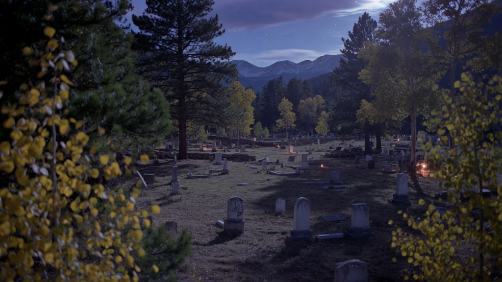
Three thousand graves climb the lower slope of Boulder Mountain above 9,300 feet—no grid, no paths, just headstones following the terrain since four-year-old Rachel Farrow was buried here in 1875. Read the stones: shaft collapses, dynamite, the 1906 avalanches that killed twelve men at the Shenandoah Mine in one slide. Then find the 1969 marker over the flu trenches, where Silverton laid roughly ninety people in two mass graves after the 1918 epidemic killed a tenth of the town in under two weeks.
→ Three more haunted places & dark-history spots in Durango — never the same twice
The story
When four-year-old Rachel Farrow died in 1875, Silverton hadn't bothered to lay out a formal town grid for its dead. They buried her on the lower slope of Boulder Mountain above 9,300 feet, establishing a pattern that lasted nearly a century. Three thousand graves now climb those twenty acres of steep alpine terrain, completely indifferent to right angles, paths, or property lines. You won't find manicured lawns or orderly family plots here—just sun-bleached wooden markers, rusting iron cribs, and headstones wedged wherever pickaxes could break through high-altitude rock and mountain root.
Walking the slope is a direct catalog of early San Juan mining hazards. Read the inscriptions closely and you'll trace early deaths caused by premature dynamite blasts, cage drops, rockfalls, and snowslides—including markers tied to the 1906 avalanche at the Shenandoah Mine that claimed twelve men in a single strike. But the steepest toll on the hill sits beneath two plain grassy depressions. When the 1918 influenza epidemic struck Silverton, it killed roughly ten percent of the town's population in under two weeks. Ground was freezing and undertakers were overwhelmed, so workers dug two long mass trenches to bury roughly ninety people without individual headstones. It wasn't until 1969 that a stone monument was finally placed over the site to mark where they lay.
What it's like
Expect a serious workout for your lungs and legs. Once you drive up County Road 34A to the gate, there are no paved walkways or handrails—just steep, uneven mountainside where you're constantly picking your way through high grass, gopher holes, and iron-fenced plots slanting down the grade. Budget at least two hours if you want to explore the upper markers or locate the flu trenches, and bring sturdy footwear and water, as the incline and thin 9,300-foot air will tire you out fast. If you want to research specific names before climbing, the San Juan County Historical Society publishes Freda Peterson's burial record volumes, which document every recorded interment on the hill.
The move: Hike up at golden hour and take turns reading epitaphs aloud until you find the 1969 flu-trench marker, then count how many stones name an avalanche.
📍 Before you go Drive north out of town on Greene Street (CO-110); where the pavement bends hard left, keep right onto the dirt road and bear left at the split—the gate is about a quarter mile up. The twenty acres have no grid and no paved paths, just steep grassy mountainside at altitude, so wear real shoes and budget more time than you think (two hours barely covers it). The San Juan County Historical Society maintains the grounds and publishes Freda Peterson's burial-record volumes if you want names to hunt. Pairs naturally with the Christ of the Mines shrine on Anvil Mountain across the valley.
- 📍 Silverton
- 💸 $$
- ⚡ Up for anything
- 🌗 Indoors
Where: County Road 34A, off CO-110/Greene St just north of town, Silverton, CO 81433
Hours: Added 2026-06-11 — confirm current hours before you go.
Pair it with
- Christ of the Mines Shrine — Look straight across the valley from Hillside Cemetery to Anvil Mountain to see this 12-ton Carrara marble shrine built to protect the miners who ended up buried on this slope.
- Grand Imperial Hotel — Head back down Greene Street into town to visit the 1880s hotel where many of Silverton's boom-era miners lodged before meeting their fates on the mountain.
- Old Hundred Gold Mine Tour — Head four miles down the gulch to step inside a real underground hard-rock shaft and see the environment responsible for so many burials on Boulder Mountain.
- Silverton Skijoring on Blair Street — Pair a quiet walk among the mining casualties with the high-speed chaos down on Blair Street if you're visiting during February.
More weird in Durango
Good to know
How do I drive to Hillside Cemetery from town?
Drive north out of Silverton on Greene Street (CO-110). Where the pavement curves hard to the left, stay right onto the dirt road and bear left at the split onto County Road 34A; the main entrance gate sits about a quarter-mile up.
Where is the 1918 flu mass grave located in the cemetery?
Look for a stone memorial marker erected in 1969. It sits over two long, subtle grass trenches where roughly ninety victims of the 1918 flu epidemic were buried together when the town's death rate outpaced individual grave digging.
Is Hillside Cemetery wheel-chair accessible or easy to walk?
No. The entire 20-acre property sits on an unpaved, steep alpine slope with no paved paths or flat terraces. Good hiking shoes and steady footing are required.
Who maintains the cemetery records?
The San Juan County Historical Society maintains the grounds and records, including multi-volume burial indexes compiled by local historian Freda Peterson.
Plan a visit & invite your people →
Further reading: rmpbs.org · sanjuancountyhistoricalsociety.org · Roadside America · ksut.org · The Denver Post · Reddit
last checked: 2026-06-11