Entry No. 37 — the Colorado Springs file — filed under: fire-tower
Devil's Head Lookout
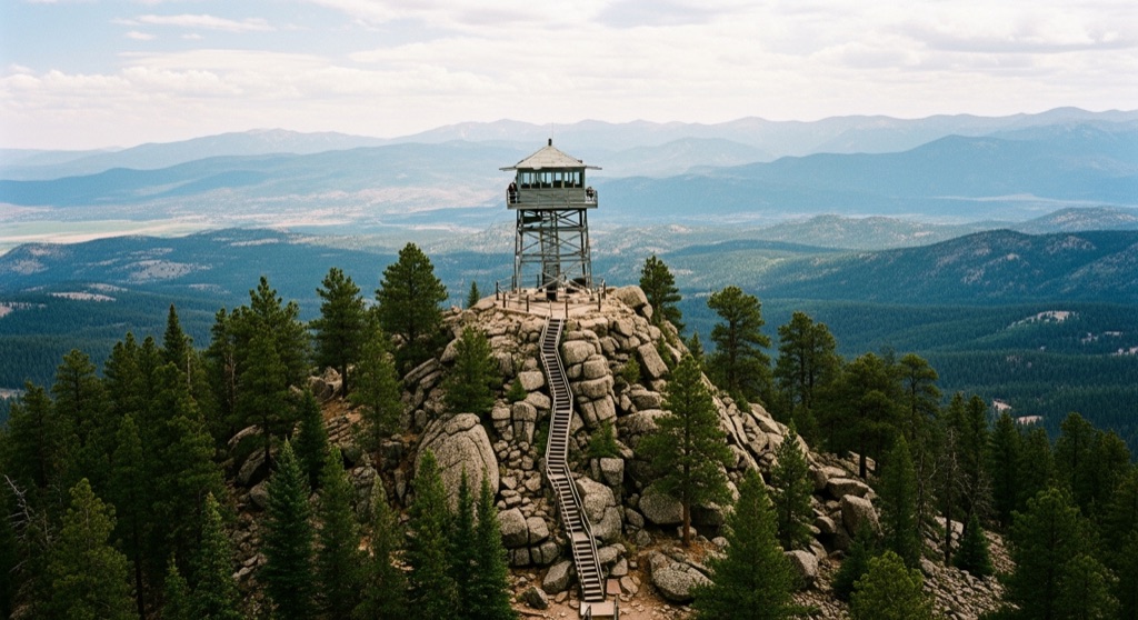
Devil's Head is Colorado's last staffed fire lookout — a working ranger mans the historic 1912 tower from roughly mid-May through mid-September, and on a clear day the 143-stair climb to the cab rewards you with a jaw-dropping 360-degree panorama stretching 100 miles across the Front Range. The ranger typically welcomes small groups up into the cab and will point out landmarks and chat about how the fire-detection equipment still works.
→ Three more weird outdoor & roadside oddities in Colorado Springs — never the same twice
The story
While satellite networks and automated thermal cameras scan the American West for smoke, the U.S. Forest Service still relies on a low-tech arrangement atop a 9,748-foot granite monolith in Pike National Forest. Devil’s Head is Colorado’s last continuously staffed fire lookout tower. The site was selected back when William Kreutzer—the nation’s first official forest ranger—patrolled these ridges at the turn of the century. A crude sighting table was clamped to the summit rock in 1912, and in 1919, the lookout made national news by hiring Helen Dowe. As the second female fire lookout in U.S. history and the first in Colorado, Dowe spent three seasons spotting dozens of blazes from this isolated peak.
The current cab, reconstructed in 1951 to replace earlier timber structures, sits perched atop sheer rock face. Inside the 14-by-14-foot glass enclosure, the ranger doesn't just sit around for show; they operate an Osborne Fire Finder, a mechanical circular brass sighting device designed over a century ago. When smoke rises anywhere within a 100-mile radius, the ranger sights through the mounted vanes, calculates the azimuth on a topographic map disc, and radios dispatch with precise coordinates before a burn can spread across Front Range pine.
What makes Devil's Head genuinely odd isn't just that it survived the shift to digital surveillance—it's that a working ranger still lives in a tiny log cabin in the meadow below from mid-May through mid-September. Up in the cab, surrounded by open air and heavy lightning grounding cables, you aren't looking at a preserved museum display; you're standing in an active emergency dispatch station held together by glass, iron bolts, and human eyesight.
What it's like
Getting there requires enduring a nine-mile stretch of unpaved, washboard dirt along Rampart Range Road that will rattle your hubcaps—a standard 2WD vehicle can handle it in dry conditions, but drive slowly. The 1.4-mile hike ascends 865 feet through shaded Douglas fir and ponderosa pine before bringing you to the final obstacle: 143 steel stairs bolted directly into bare granite. If you get jittery with heights, looking through the open metal mesh treads will test your nerves, but the summit cab makes it worth the climb. On clear summer days, the ranger invites small groups inside to demonstrate how the Osborne Fire Finder spins across the topo map. Aim for a mid-morning arrival on a weekday to grab a spot in the free trailhead lot, carry water, and note there are no trash cans along the trail—though a short spur near the top leads to a wooden privy overlook with a remarkable angle of the range.
The move: Arrive mid-morning on a weekday to beat weekend crowds, hike the 1.4-mile trail through ponderosa forest to the granite outcrop, then climb all 143 stairs together into the lookout cab — the ranger will narrate the view and show you the Osborne Fire Finder. Pack a lunch to eat on the rocks just below the tower with the Rockies sprawling in every direction, then take the short spur to the lookout's privy overlook for a second angle before heading back down.
📍 Before you go It's a real drive — head to Sedalia, west on Highway 67, then south on Rampart Range Road, the last stretch of which is unpaved. The dirt road is generally fine for a 2WD car but gets dusty and washboarded near the end; it's plowed-out closed for winter (roughly December onward), so this is a late-spring-through-fall outing that lines up with the staffed-tower season. Free parking sits at the trailhead base and fills fast on summer weekends, with overflow a short walk away — another reason to come early on a weekday. There's a small USFS campground right by the trailhead if you want to pair the climb with a night out and be first up the stairs at dawn. It's exposed granite at altitude, so carry water and sun protection. Hours shift seasonally — check ahead.
- 📍 Sedalia
- 💸 Free
- ⚡ Up for anything
- 🌗 Outdoors
Where: 6518 S Rampart Range Rd, Sedalia, CO 80135
Hours: Mined 2026-06-07 — confirm current hours before you go.
Pair it with
- Cherokee Ranch & Castle — Follow up your trek to a working 1950s fire tower with a tour of a 15th-century Scottish-style stone castle built on the Sedalia prairie.
- Scileppi's at the Old Stone Church — Descend from eating lunch on 9,700-foot granite rocks to sip drinks and eat Italian inside an 1888 rhyolite-stone Catholic church in nearby Castle Rock.
- Provision — Balance a dusty dirt-road drive and 143 metal stairs with a craft cocktail hidden behind a swinging bookcase on Wilcox Street.
- A Sanctuary Center — Extend your outdoor outing in Sedalia with a quiet walk through a volunteer-run sacred garden featuring a labyrinth and stone medicine wheel.
More weird in Colorado Springs


Good to know
When is the lookout tower open to visitors?
The tower cab is typically staffed and open to visitors from mid-May through mid-September. Rampart Range Road is unplowed and closed to vehicles during the winter season, usually starting around December.
Do I need a four-wheel-drive vehicle to reach the trailhead?
No, standard 2WD passenger cars can make the drive in dry weather, though the last nine miles along Rampart Range Road are unpaved, dusty, and heavily washboarded.
Is the tower actually still used to spot forest fires?
Yes. It is the last working, staffed fire lookout in Colorado. The ranger on duty uses a vintage mechanical Osborne Fire Finder to visually pinpoint smoke and relay coordinates to fire crews.
How difficult is the hike up to Devil's Head?
It is a moderate 1.4-mile hike (2.8 miles round-trip) with an 865-foot elevation gain, culminating in a steep climb up 143 metal stairs attached to the granite summit.
Plan a visit & invite your people →
Further reading: fs.usda.gov · Tripadvisor · Yelp · intermountainhistories.org · Reddit
last checked: 2026-06-07