Entry No. 33 — the Colorado Springs file — filed under: outdoor
Castlewood Canyon Dam Ruins
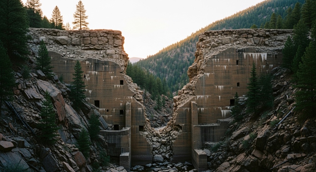
The crumbling concrete shell of the 1890 Castlewood Dam still stands in two massive broken halves, the gap between them marking the exact point where a 15-foot wall of water tore loose at 1 a.m. on August 3, 1933, and roared 40 miles down Cherry Creek to flood downtown Denver. You can walk right through that breach on established trails while the canyon walls and stunted pines make it feel genuinely remote and eerie.
→ Three more abandoned & forgotten places in Colorado Springs — never the same twice
The story
In 1890, the Denver Water Storage Company threw up a 600-foot-long, 70-foot-tall rockfill and stone masonry dam across Cherry Creek to store water for Douglas County's dairy farms and potato fields. It was a compromised build from the start. Within months of completion, stone blocks settled, mortar cracked, and water began weeping through the lower face. Downstream residents in Denver fretted constantly about a catastrophic breach, but the dam's chief engineer, A.M. Welles, famously scoffed at the panic, declaring that Castlewood Dam would never break in his lifetime or for generations to come.
It lasted 43 years. At 1:20 a.m. on August 3, 1933, after days of cloudbursts dumped up to nine inches of rain into the basin, the weakened center wall surrendered. A 15-foot wall of a billion gallons of water tore out the dam's middle section and roared 40 miles down Cherry Creek straight into downtown Denver. Midnight telephone switchboard operators stayed at their posts calling down the valley to wake sleeping families, keeping the death toll to two while the deluge ripped out bridges and dumped 20,000 tons of mud onto Larimer Street.
Nobody rebuilt the structure. Instead, state park authorities left the carcass where it fell, cradled inside a quiet canyon of scrub oak and stunted ponderosa pines. Today, the broken halves stand like abandoned ancient monoliths—two massive, hand-laid masonry abutments staring across a wide gap where Cherry Creek flows through the exact point of collapse.
What it's like
You'll park at the Canyon Point lot inside Castlewood Canyon State Park (or the west entrance off Highway 86) and hike roughly a mile down the Inner Canyon loop to the streambed. The approach feels deceptively docile—creekside gravel, swallows nesting in sandstone walls, and shallow water where families splash—until you turn a bend and the twin stone ruins loom over the trees. You can walk straight through the blown-out center gap, pick around scattered cut stones in the brush, or take the built-in stairs up the east abutment to stand on top of the wall. The park is strictly day-use from sunrise to sunset, so time your visit carefully if you want dusk light; rangers patrol closing times strictly, and winter snow turns the steep canyon steps into icy hazards.
The move: Hike the Castlewood Canyon Ruins Loop (roughly 2 miles) at dusk — pick your way through the broken dam gap, scramble up to the top of the standing east abutment for a panoramic view of the canyon, then find a quiet ledge along Cherry Creek below the ruins to sit with a thermos and watch the light fade over the same streambed that carried the flood.
📍 Before you go The ruins sit inside Castlewood Canyon State Park, so you'll need a Colorado state-parks pass or pay the day-use fee at the entrance. The Hwy 83 address is the main (east) entrance, where you'll find the visitor center and the Canyon Point lot; from there it's an easy hike-in of roughly two miles down the Inner Canyon / Lake Gulch loop to the dam — there's no parking at the ruins themselves. (A west entrance off Hwy 86 reaches the dam too.) The park is day-use only, open sunrise to sunset, so a dusk visit means timing it tight and being back out as the light goes. Spring through fall is easiest; canyon trails get snowy and icy in winter — check ahead. Picnic areas near the main entrance make an easy pairing.
- 📍 Franktown
- 💸 Free
- ⚡ Up for anything
- 🌗 Outdoors
Where: 2989 S State Hwy 83, Franktown, CO 80116
Hours: Mined 2026-06-07 — confirm current hours before you go.
Pair it with
- Scileppi's at the Old Stone Church — Trade shattered 1890 stone dam masonry for dinner inside Castle Rock's 1888 rhyolite-stone church, where the bar stands inside the original altar space.
- Provision — Follow a hike through 1930s flood history with 1920s craft cocktails served behind a swinging bookcase on Wilcox Street.
- B&B Cafe — Pair the dam's dramatic history with Castle Rock's 1946 diner, where vintage bullet holes remain visible in the tin ceiling and safe.
- Cherokee Ranch & Castle — Double down on Douglas County's strange stonework by heading west to tour a 15th-century-style Scottish castle rising off the prairie.
More weird in Colorado Springs
Good to know
How do I reach the Castlewood Canyon Dam ruins?
Park at the Canyon Point lot near the main east entrance on Highway 83 and hike down the Inner Canyon / Lake Gulch loop roughly one mile to the canyon floor. Alternatively, use the west park entrance off Highway 86.
Is there an entry fee to see the dam?
Yes. Because the ruins are inside Castlewood Canyon State Park, you must pay the daily park vehicle entrance fee or display a valid Colorado State Parks pass.
Can you go onto the dam ruins?
You can hike right through the breach along the creek trail and climb stairways built onto the standing east abutment for views from the top. Scrambling onto untrail masonry is prohibited to preserve the historic structure and prevent falls.
What are the visiting hours?
The park is day-use only, open daily from sunrise to sunset year-round. Night hiking is not permitted.
Plan a visit & invite your people →
Further reading: cpw.state.co.us · coloradoencyclopedia.org · Tripadvisor · damfailures.org · historycolorado.org
last checked: 2026-06-07