Entry No. 32 — the Boulder file — filed under: ghost town
Ward Ghost Town (Old Ward)
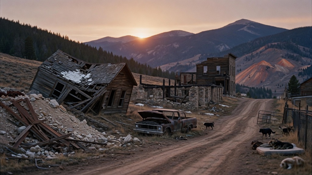
Ward began as a silver and gold camp in 1860 when Calvin Ward staked his claim at a site called Miser's Dream. By the 1880s it ranked among the richest towns in Colorado, with one mine eventually pulling more than two million troy ounces of silver from the mountains. In January 1900, fire consumed over fifty buildings, but the mines were profitable enough that the town rebuilt almost immediately. Then the ore gave out. The rebuilt Ward shrank to a ghost of itself by the 1920s, and in the 1960s the remaining handful of year-round residents were joined by waves of hippies who came for the cheap land and the altitude. Their descendants still live here — about 128 people by the last census — in a town famous for its deliberate unwelcoming posture: derelict vehicles arranged roadside, dogs loose in the streets, and a long-running local tradition of removing directional road signs.
→ Three more abandoned & forgotten places in Boulder — never the same twice
The story
In 1860, prospector Calvin Ward staked a claim at a site dubbed Miser’s Dream, triggering a rush that turned this high-alpine slope into one of Colorado’s richest mining camps. The discovery of the Columbia vein pushed Ward into overdrive, with one mine alone eventually dragging more than two million troy ounces of silver out of the mountain. By 1897, the narrow-gauge Switzerland Trail railroad was hauling hundreds of passengers daily up 4,100 vertical feet from Boulder. Even when a wall of fire torched over fifty buildings in January 1900, the mines were turning enough profit that the town rebuilt almost immediately.
Then the ore vanished, the mines closed, and Ward shrank into a half-empty mountain shell by the 1920s. But unlike typical ghost towns that quietly rotted into dust, Ward was reclaimed in the 1960s by homesteaders, draft dodgers, and hippies seeking cheap land, thin air, and total detachment from mainstream society. They built an off-the-grid refuge at 9,450 feet, relying on wood stoves, hand pumps, and an unwritten pact of radical self-reliance.
Today, roughly 128 residents inhabit the remaining cabins and improvised structures. You won't find a gift shop or visitor center here; instead, you’ll find a long-standing local posture of deliberate resistance to outside intrusion. You didn't hear it from us, but those missing directional road signs aren't county negligence—locals have a decades-long tradition of tearing them down to keep lost outsiders off their dirt tracks, backed up by loose dogs roaming the roads and roadside lineups of rusting vintage cars parked like territorial markers.
What it's like
Pulling off Highway 72 onto the narrow dirt grid of Columbia and Utica Streets, the 9,450-foot altitude hits your lungs almost as fast as the standoffish atmosphere. You'll drive past collapsed 19th-century cabins, mine tailings, loose dogs trotting along the road, and line-ups of rusting beaters decaying into the pine needles. Keep your eyes open and your head down: residents value their privacy fiercely, so stay strictly on public roads and do not trespass or attempt to enter any structures. Visit on a clear summer afternoon when the dirt lanes are dry, take a quiet loop past the pre-1900 ruins, and head back down Left Hand Canyon before sunset.
The move: Drive the Peak to Peak Highway up to Ward on a clear afternoon, park on Columbia Street, and walk the dirt roads past collapsed cabins and mine tailings as the sun drops behind the Continental Divide. Stop at Utica Street to find remnants of the pre-1900 town, then warm up with hot drinks in the car on the way back down Left Hand Canyon.
📍 Before you go Ward sits at 9,450 feet — altitude hits fast, especially if you come straight from Boulder (5,430 ft). The town is open to drive and walk year-round, but the dirt roads through the older sections can be impassable in deep snow; visit May through October for best access. No admission, no hours, no services. Residents are private; stay on roads and do not enter structures or private property. The nearest gas is in Nederland, about 9 miles south on CO-72.
- 📍 Ward
- 💸 Free
- ⚡ Up for anything
- 🌗 Outdoors
Where: Columbia Street, Ward, CO 80481 (Peak to Peak Highway / CO-72, ~20 miles northwest of Boulder)
Hours: Added 2026-06-11 — confirm current hours before you go.
Pair it with
- Gold Hill Historic District (Colorado's First Mining Town) — Five miles away via dirt mountain roads, Gold Hill offers another preserved 1859 mining settlement without Ward's intentionally unwelcoming local posture.
- Caribou Ghost Town — Contrast Ward's inhabited counterculture survival with Caribou, a nearby silver camp above 10,000 feet that was completely erased by fire and high-alpine winters.
- Jamestown Mercantile — Head seven miles down the canyon to Jamestown's historic mercantile for warm food and live music after experiencing Ward's frosty local reception.
- Ward Townsite & Derelict Car Collection — Explore Ward's dirt road perimeters to inspect the open-air lineup of abandoned vintage trucks and beaters parked as local territorial boundaries.
More weird in Boulder
Good to know
Is Ward completely abandoned?
No. Ward is an active home-rule municipality with about 128 year-round residents, making it a living hybrid of an 1860s silver camp and an off-grid mountain enclave.
When is the best time of year to visit?
May through October is ideal. At 9,450 feet, heavy snow makes the unpaved side roads around the historic townsite impassable for standard vehicles in winter.
Are there gas stations, shops, or restrooms in Ward?
There are no gas stations, public restrooms, or tourist services in Ward. The nearest fuel and supplies are about 9 miles south on CO-72 in Nederland.
Can I walk up to or go inside the historic mine ruins and cabins?
No. All surviving buildings and mine tailings are private property or unsafe structures. You must stay on public dirt roads and view the ruins from a distance.
Plan a visit & invite your people →
Further reading: Wikipedia · Official site · westernmininghistory.com · thirstcolorado.com · Reddit
last checked: 2026-06-11