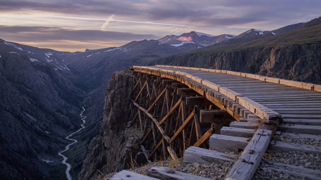
Entry No. 11 — the Boulder file — filed under: abandoned railroad
Devil's Slide Trestles (Rollins Pass)
Clinging to the edge of a cliff at 11,475 feet, the Devil's Slide Trestles are twin wooden railroad bridges built in 1904 as part of David Moffat's Denver, Northwestern & Pacific Railway — one of the highest standard-gauge railroads ever constructed in the United States. The 128-foot main trestle spans more than 1,000 feet above the South Fork of Middle Boulder Creek; the drop is so sheer that three Statues of Liberty stacked together still wouldn't reach the deck level. Trains ran this route until 1928, when the 6.3-mile Moffat Tunnel made the pass redundant. The tracks came out in 1938, the road followed in 1955, and a tunnel collapse in 1990 closed the route permanently to vehicles. What remains are the timber bents — built by 17 workers using footers carved into bare rock — still standing after 120 winters.
→ Three more abandoned & forgotten places in Boulder — never the same twice
The story
In 1904, industrialist David Moffat set out to cross the Continental Divide without waiting for a long tunnel to be drilled, laying standard-gauge track over Rollins Pass at an elevation of 11,475 feet. Negotiating a sheer cliff face above the South Fork of Middle Boulder Creek required audacious engineering: seventeen workers carved footers directly into bare granite and erected twin timber trestles hanging over open space. The main 128-foot trestle pinned itself to the rock ledge over a drop exceeding 1,000 feet—a abyss so deep that three Statues of Liberty stacked on top of each other at the bottom wouldn't reach the rail deck.
For twenty-four years, steam locomotives dragged freight and passengers along this wooden shelf while crewmen fought high-alpine blizzards and whiteouts. When the 6.3-mile Moffat Tunnel opened far below in 1928, the high surface route was rendered obsolete overnight. Scrap crews pulled the steel rails in 1938, and in 1955 the old rail grade was converted into an unpaved mountain road for thrill-seeking drivers. That era ended in 1990 when a rock collapse inside the nearby Needle's Eye Tunnel permanently severed vehicle traffic across the pass, leaving the decaying timber bents behind to face the elements alone after 120 mountain winters.
What it's like
Reaching the trestles starts with a rough, unmaintained crawl up County Road 16 out of Rollinsville, where exposed rock and deep ruts make high-clearance 4WD mandatory. When the road dead-ends at the gate roughly 1.25 miles from the site, you kill the engine and finish the trip on foot or mountain bike along the wide, flat railroad grade. The vibe at 11,475 feet is quiet, wind-scoured, and dizzying. You can walk right up to the cliff edge to inspect the hand-carved rock footings and heavy timbers clinging to the wall, but do not attempt to set foot on the wooden structures themselves—they are unstable and strictly off-limits. Pack heavy layers even in midsummer, head down before afternoon lightning rolls over the Divide, and verify road status at preserverollinspass.org before leaving town.
The move: Drive the rough 4WD road from Rollinsville and hike the final 1.25 miles along the old rail grade to reach the trestles. Stand at the edge with nothing but thin mountain air and a thousand-foot drop below the boards, then sit on the grade with sandwiches and a view of the Continental Divide that no locomotive has seen since Prohibition.
📍 Before you go Seasonal access only: the road typically opens around June 15 and closes November 15, though snow can push opening to early July. A high-clearance 4WD vehicle is required on the east (Rollinsville) side — the road is unmaintained with exposed rock. The final 1.25 miles to the trestles is on foot or bike; the trestles themselves are not safely crossable. Check current road status at preserverollinspass.org before heading out. No fees, no reservations.
- 📍 Boulder
- 💸 Free
- ⚡ Up for anything
- 🌗 Outdoors
Where: Rollins Pass Road (County Road 16), accessed from Rollinsville, CO 80474 (east approach); road ends ~1.25 miles from trestles
Hours: Added 2026-06-11 — confirm current hours before you go.
⚠ Seasonal or scheduled — always check before you go.
Pair it with
- Moffat Tunnel East Portal — After staring down from the harrowing 1904 high-altitude rail line, head down the mountain to see the east portal of the 6.3-mile bore that rendered the pass obsolete in 1928.
- Train Cars Coffee & Kava — Swap thin alpine air and weather-beaten timber trestles for warm coffee served inside three restored century-old train cars in Nederland.
- Stage Stop (Historic Rollinsville Stage Station) — Pass this 1868 Butterfield stagecoach toll station located right at the turnoff in Rollinsville before starting your 4WD ascent up County Road 16.
More weird in Boulder
Good to know
How do you reach the Devil's Slide Trestles?
Drive County Road 16 west from Rollinsville in a high-clearance 4WD vehicle to the closure gate, then hike or mountain bike the final 1.25 miles along the old railroad grade.
Can you walk on or across the wooden trestles?
No. The trestles are structurally unstable, closed to all pedestrian traffic, and unsafe to step on. You can view them clearly from the safety of the adjacent rail grade.
Is there a fee or reservation needed to visit?
No, access across Rollins Pass is free and requires no permits or advance reservations.
What time of year is the access road open?
The road is strictly seasonal, typically opening around June 15 and closing November 15, though high snowpack can delay opening into early July.
Plan a visit & invite your people →
Further reading: Official site · Atlas Obscura · dangerousroads.org · Reddit
last checked: 2026-06-11