Entry No. 35 — the Boise file — filed under: outdoor-weird
Little City of Rocks
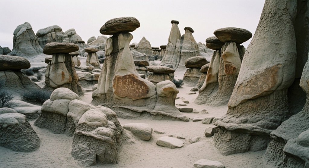
This BLM wilderness study area is packed with hoodoos, mushroom caps, spires and natural arches eroded out of pale rhyolite laid down by ancient Yellowstone-hotspot eruptions millions of years ago. A main trail threads into the heart of the formations, with side paths leading to weirder shapes you can scramble around on. Tucked among the rocks are petroglyphs carved by Native Americans thousands of years ago.
→ Three more weird outdoor & roadside oddities in Boise — never the same twice
The story
Roughly eight million years ago, the Yellowstone hotspot sat directly beneath southern Idaho, tearing open the crust and blasting out massive volumes of ash and pale rhyolite across the Bennett Hills. Over millions of years, water, wind, and frost eroded those volcanic deposits into a high-density grid of hoodoos, mushroom caps, fins, and spires. The result looks unnervingly like a abandoned miniature skyline rising straight out of the high-desert sagebrush.
It isn't just a geologic anomaly. Long before the Bureau of Land Management designated these 5,875 acres as a Wilderness Study Area, Native Americans navigated this canyon, carving petroglyphs into the rhyolite walls thousands of years ago. While crowds head south to the better-known City of Rocks National Reserve near the Utah border, this northern canyon stays mostly empty, leaving the stone alleyways silent.
What it's like
Drive about 12.5 to 14 miles north of Gooding on Highway 46 and turn onto a dirt access road that crosses private land. If recent rain has turned the dirt to paste, the local landowners shut the access gate, which means parking at the fence and walking the extra mile to the trailhead. High-clearance vehicles handle the rutted dirt best. The main canyon hike follows a seasonal creek with under 400 feet of elevation gain for about 1.5 miles before the trail fades into off-trail rock scrambling. Shade does not exist out here, ticks live in the spring brush, and summer heat bakes the pale stone, so pack plenty of water and hit the dirt early.
The move: Take the short dirt road off Highway 46 and spend an afternoon wandering the maze of arches and hoodoos hunting for the ancient rock art.
📍 Before you go About 12.5 miles north of Gooding on Highway 46, then a short dirt road; primitive camping allowed; bring water and shade, the trail takes a couple hours to explore.
- 📍 Gooding
- 💸 Free
- ⚡ Up for anything
- 🌗 Outdoors
Where: Idaho Highway 46, Gooding, ID 83330
Hours: Added 2026-06-24 — confirm current hours before you go.
Pair it with
- Cowboy Muffler Man — Swap millions of years of natural rhyolite hoodoos for a 22-foot fiberglass giant watching over an RV park in nearby Wendell.
- Idaho's Mammoth Cave & Shoshone Bird Museum of Natural History — Pair your open-air walk among volcanic spires with a trip inside a dark lava tube and an eccentric natural history display in Shoshone.
- Balanced Rock — Head south toward Castleford to see a 40-ton volcanic boulder perched impossibly on a three-foot-wide base.
More weird in Boise
Good to know
How do I reach the Little City of Rocks trailhead?
Drive roughly 12.5 to 14 miles north of Gooding on Idaho State Highway 46, turn west at the BLM sign onto the dirt access road, and follow it about 1.1 miles to the parking pull-off.
Is there an entrance fee or set hours?
No entrance fees or official open hours exist for this public BLM area, but you should check road conditions before visiting because muddy weather prompts landowners to close the dirt access road.
How long is the hike and how hard is it?
The basic in-and-out trail along the canyon floor is about 3 miles round-trip with mild elevation gain, taking roughly 1.5 to 2 hours. Pushing beyond the split for a full 4.9-mile loop requires scrambling off-trail over rough rhyolite.
Are there petroglyphs at Little City of Rocks?
Yes, ancient rock art carved by Native Americans thousands of years ago is tucked into rock faces along the side paths branching off the main canyon trail.
Plan a visit & invite your people →
Further reading: Wikipedia · visitsouthidaho.com · blm.gov · digitalatlas.cose.isu.edu
last checked: 2026-06-24