Entry No. 7 — the Anchorage file — filed under: ghost town
Portage Ghost Town (the town the 1964 quake sank)
“dropped 8 to 10 feet in under five minutes”
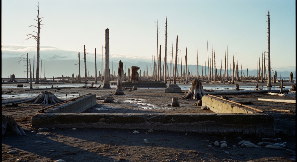
Once a busy rail-and-road junction, Portage dropped 8 to 10 feet in under five minutes during the 1964 magnitude 9.2 Good Friday earthquake — putting it below high tide. Residents abandoned it rather than rebuild. What's left is a scatter of structural ruins and a drowned 'ghost forest' of salt-killed trees, slowly being reclaimed.
→ Three at a time, never the same twice — explore weird Anchorage
The story
On Good Friday, March 27, 1964, a 9.2 magnitude earthquake shook Southcentral Alaska so violently that the soft soils beneath Portage liquefied. In under five minutes, the bedrock subsided and dropped the settlement eight to ten feet. Portage was a vital transit junction along Turnagain Arm—a bustling pit stop where travelers fueled up, grabbed lunch, or drank cocktails cooled with ice chopped straight off nearby Portage Glacier. When the shaking hit, fissures split the earth beneath buildings, mud spouts shot up to a hundred feet high, and the entire plain plunged below high tide level.
The town wasn't instantly wiped away by shaking alone; its death sentence was delivered weeks later by the ocean. High spring tides from Turnagain Arm swept over the dropped valley floor, smothering the terrain in glacial silt and drowning the roots of the spruce forests in saltwater. Residents abandoned their homes and service stations rather than attempt rebuilding on land that flooded twice a day. The salt preserved the dead wood instead of rotting it quickly, stripping away the bark and leaving stands of dead, silvery spruce trunks standing like gray bones in the marshland.
Decades later, nature is quietly swallowing what remains. The wooden cabin frames and old horse stables have mostly collapsed into rotting timbers half-buried in tidal silt and marsh grass. What endures is the eerie 'ghost forest'—a stark, silent monument to the moment the Earth dropped out from under an Alaskan town. You can drive past it at 55 miles per hour without realizing you're looking at a drowned settlement, but if you pull over, the scale of the destruction becomes uncomfortably clear.
What it's like
Drive about 47 miles south of Anchorage on the Seward Highway toward the Whittier cutoff, and keep your eyes on the flats around Mile 80. There's no official sign for the townsite, just gravel pullouts along the highway where you can park. Time your visit for low tide if you want to walk near the silvery tree trunks and rotted cabin foundations, but keep your boots firmly on vegetated ground near the highway. The grey mudflats of Turnagain Arm look deceptively firm, but the fine glacial silt acts like quicksand, and the incoming bore tide rushes back faster than you can run. Visit between late spring and autumn before winter snow buries the ruins entirely.
The move: Drive the Seward Highway south, park near the old townsite/ghost forest, and wander the skeletal trees and home-site remains at low tide — a moody, end-of-the-world photo walk with a 9.2-earthquake story behind every ruined foundation.
📍 Before you go Drive the Seward Highway roughly 47 miles south of Anchorage, down the Turnagain Arm corridor toward the Portage Lake and Whittier cutoff. There's no formal townsite sign; watch the flats between the road and the water for the silvery stand of dead trees and pull off at one of the gravel turnouts. Go at low tide if you want to walk among the ruins, and stay near solid ground: Turnagain Arm's glacial-silt mudflats can trap you and the tide returns fast, so don't venture far out. Snow buries most of it in winter, making late spring through fall the practical window. Pair it with the nearby Alaska Wildlife Conservation Center or a run up Portage Glacier Road to the Begich Boggs Visitor Center and Portage Lake.
- 📍 Turnagain Arm (Seward Highway corridor)
- 💸 Free
- ⚡ Up for anything
- 🌗 Outdoors
Pair it with
- Nike Site Summit — Pair a sunken, salt-drowned town site at sea level with an abandoned Cold War nuclear missile battery perched 3,900 feet up in the Chugach Mountains.
- ARLIS Wildlife Realia Collection (Alaska Resources Library) — Trade the weather-bleached outdoor tree skeletons of Turnagain Arm for an obscure university library where you can check out real animal skulls and taxidermy furs.
- Valley of the Moon Park (the old crib-house red-light row) — Follow up a town swallowed by the 1964 earthquake with a quiet urban park hiding Anchorage's relocated 1916 brothel row.
More weird in Anchorage


Good to know
How do I spot the Portage ghost town from the Seward Highway?
Look for gravel turnouts near Mile 80 where Turnagain Arm meets the Portage Lake and Whittier cutoff. You will see stands of stark, silvery dead spruce trees standing in the saltwater marsh between the road and the water.
Is it safe to walk out into the ghost forest and mudflats?
Only stay on firm, grassy ground right near the turnout. Do not step far onto the grey mudflats—Turnagain Arm's fine glacial silt traps feet like quicksand, and incoming high tides flood the area rapidly.
Why are the dead trees still standing six decades after the quake?
When the ground subsided, saltwater inundated the spruce roots and killed the trees instantly. High salinity and fine tidal sediment preserved the trunks, stripping their bark and leaving rot-resistant gray skeletons that remain standing decades later.
What remains of the original town buildings today?
Most structures collapsed under tidal flooding or rotted into low timber outlines swallowed by vegetation and silt. You can still spot the skeletal remains of wooden cabin foundations and an old horse stable near the tree line.
Plan a visit & invite your people →
Further reading: Wikipedia · thealaskalife.com · alaska.org · routefifty.com
last checked: 2026-06-06