Entry No. 64 — the Anchorage file — filed under: ghost_town
Old Portage Townsite
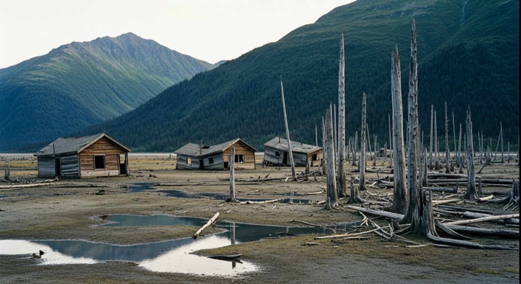
Once a bustling railroad town, Portage was completely devastated during the 1964 Good Friday earthquake when the ground subsided up to ten feet, submerging the area in saltwater. Today, all that remains of the abandoned settlement are a few decaying wooden cabins sinking into the marsh and an eerie 'ghost forest' of petrified, saltwater-killed spruce trees. The site stands as a haunting, nature-reclaimed monument to one of the most powerful earthquakes in recorded history.
→ Three at a time, never the same twice — explore weird Anchorage
The story
On Good Friday, March 27, 1964, a magnitude 9.2 earthquake shook south-central Alaska for nearly five minutes. At the head of Turnagain Arm where the Twentymile River meets saltwater, the soft, saturated glacial soils beneath Portage liquefied. In under five minutes, the entire settlement—a vital railroad-and-highway junction connecting Seward, Whittier, and Anchorage—dropped six to ten feet straight down.
That sudden subsidence placed Portage below the high-tide line. Saltwater flooded the valley twice daily, drowning the spruce forest from the roots up. Because the heavy salt concentration stalled normal organic decay, the dead trees remained standing as a gray ghost forest. Off in the marsh, a couple of rotting wooden cabins and an old horse stable continue sinking into the glaciated silt with every tidal cycle.
You won't find a sign marking where the local gas station used to stand, but the ground keeps its own ledger. Marine silt has slowly buried the sunken town, locking the 1964 surface beneath layers of peat—and geologists digging into the mudflats have found the stumps of two older ghost forests buried deeper down, proof that this coast has dropped before.
What it's like
Pull off at the designated Seward Highway turnouts around Mileposts 80 to 89 at the head of Turnagain Arm. You will see pale, barkless spruce trunks standing against the Chugach Mountains, with decaying wooden cabin frames slumping into the marsh. Keep your feet on the gravel highway shoulder: the surrounding mudflats consist of fine glacial silt that acts like quicksand, and Turnagain Arm's incoming tides move dangerously fast. Aim for low tide if you want to see more of the submerged wood exposed above the silt.
The move: Pull off the Seward Highway at the designated viewing areas to safely photograph the sunken cabins and the eerie ghost forest against the backdrop of the Chugach Mountains.
📍 Before you go The ruins sit in a marshy tidal flat subject to extreme high tides, unstable mudflats, and quicksand-like silt, making it highly dangerous to walk out to the structures. Visitors should safely view and photograph the site from the highway pullouts.
- 📍 Girdwood
- 💸 Free
- ⚡ Low-key
- 🌗 Outdoors
Where: Girdwood, AK 99587, USA
Hours: Added 2026-07-20 — confirm current access before you go.
Pair it with
- Whisperwood Witchery — Just ten miles back up Turnagain Arm in Girdwood, you can shift from natural disaster ruins to handcrafted metaphysical supplies at this local vendor.
- Glen Alps / Flattop Mountain Dark-Sky Overlook — Head 30 miles north into the Chugach foothills for an elevated panoramic view looking back across Turnagain Arm.
- Gravity Hill — On your way back into Anchorage, stop on Upper Huffman Road to test a stretch of road where your car appears to roll uphill against gravity.
- Nike Site Summit — Trade earthquake-sunken structures for military ruins at this abandoned Cold War nuclear missile battery sitting 3,900 feet up in the Chugach Range.
More weird in Anchorage


Good to know
Can I walk out to inspect the sunken cabins up close?
No. The surrounding tidal flats consist of fine glacial silt that easily traps footwear like quicksand, combined with fast-moving Turnagain Arm tides. Viewing should strictly be done from the highway pullouts.
Why didn't the dead trees in the ghost forest rot away?
The 1964 ground subsidence exposed the spruce roots to saltwater. The salt killed the trees quickly while simultaneously acting as a natural preservative, keeping the trunks standing upright for decades.
Where along the Seward Highway should I stop to see the ruins?
Look for the designated highway turnouts near Mileposts 80 to 89 near the head of Turnagain Arm, where the Twentymile River and Portage Creek flow into the bay.
Are there any active buildings left in Old Portage?
No. The townsite was completely abandoned after the 1964 quake, and the Seward Highway and Alaska Railroad tracks had to be rebuilt on elevated fill to bypass the flooded flats.
Plan a visit & invite your people →
Further reading: Wikipedia · alaska.org · Atlas Obscura · earthquake.alaska.edu · route-fifty.com
last checked: 2026-07-20