Entry No. 18 — the Anchorage file — filed under: ghost forest
Girdwood Ghost Forest
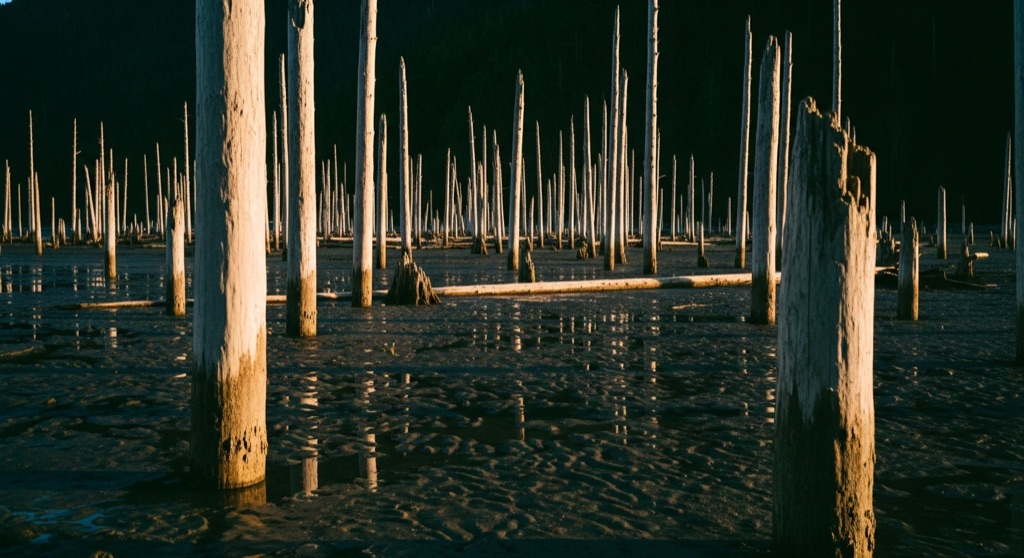
Around milepost 90 of the Seward Highway, pale columns of long-dead trees stand on the Turnagain Arm mudflats — drowned when the 1964 quake dropped the ground 6.5 feet below the tide line and saltwater killed the freshwater forest. Dig down and there are the stumps of two earlier ghost forests from quakes ~900 and ~1600 years ago.
→ Three more haunted places & dark-history spots in Anchorage — never the same twice
The story
On Good Friday in 1964, a 9.2-magnitude subduction earthquake dropped the ground along Turnagain Arm by six and a half feet in a matter of minutes. That sudden drop dragged a thriving freshwater spruce forest down below the high-tide line. Daily ocean saltwater flooded the root systems, poisoning the trees almost immediately. But instead of rotting away, the trunks were preserved: dense, oxygen-starved glacial silt sealed out the bacteria and fungi that normally break down dead timber. Today, around milepost 90 of the Seward Highway, those pale, barkless skeletons still stand upright in the tidal mud like a pickling experiment run by the planet.
Here is the detail the highway markers tend to gloss over: the 1964 forest is merely the top floor of a vertical graveyard. Dig into the tidal silt or check the exposed banks at low tide, and you will find the flattened stumps of two older ghost forests buried directly beneath your boots—relics of twin megathrust quakes that dropped this same shoreline roughly 900 and 1,600 years ago. Turnagain Arm drops, drowns a forest, buries it in mud, and grows a new one, operating on a silent cataclysmic timer.
What it's like
An hour's drive south of Anchorage down the Seward Highway lands you at plain gravel turnouts near the ghost-forest signs. Don't expect a visitor center, trailheads, or restrooms—just an unpaved pull-off and the raw wind off Turnagain Arm. The atmosphere is stark and skeletal, best caught around low tide near sunset when low light hits the bone-white trunks. Keep your boots planted on the firm bank near the highway shoulder; the glacial silt mudflats below look deceptively solid but can act like quicksand, and the incoming bore tide surges up the arm faster than a human can run. Take in the view, stay off the deep flats, and fold the stop into a sweep down the corridor past Beluga Point or the Alyeska tram.
The move: Time it for low tide near sunset, pull off at the ghost-forest signs, and walk out among the bone-white trunks — eerie, beautiful, and a quiet conversation about deep time and the three forests stacked beneath your feet.
📍 Before you go This is a roadside stop on the Turnagain Arm corridor, an easy hour or so south of Anchorage — no trailhead or facilities, just gravel pull-offs near the marked ghost-forest signs. Heed the real hazard: the Arm's glacial-silt mudflats can act like quicksand, and the bore tide rushes in faster than you can walk, so stay near the firm bank and don't strike out far. The bare trunks show year-round, but warm months make the flats safer underfoot. Fold it into the drive with the Beluga Point bore-tide pullouts, the Alyeska tram in Girdwood, or Portage Glacier toward the far end of the Arm.
- 📍 Girdwood / Turnagain Arm
- 💸 Free
- ⚡ Up for anything
- 🌗 Outdoors
Pair it with
- Eklutna Historical Park & Spirit Houses Cemetery — A striking human parallel to Girdwood's drowned forest, featuring hand-painted Dena'ina Athabascan spirit houses set over graves north of Anchorage.
- ARLIS Wildlife Realia Collection (Alaska Resources Library) — Swap salt-pickled wooden skeletons for real circulating animal skulls and taxidermy at Anchorage's university research library.
- The Last Blue Whale (a.k.a. the "Whale Drowns Men" statue) — Pair nature's seismic destruction with this 1973 downtown bronze depicting a whale capsizing boats and drowning whalers.
More weird in Anchorage

Good to know
Where is the Girdwood Ghost Forest located?
It stands along the Turnagain Arm mudflats near milepost 90 of the Seward Highway, about an hour south of Anchorage near Girdwood.
Why are the dead trees still standing after decades?
The 1964 quake dropped the land 6.5 feet into the tidal zone, drowning the roots in saltwater while fine, oxygen-deprived glacial mud encased the trunks and halted normal fungal decay.
Is it safe to walk onto the mudflats for photos?
No. The glacial silt mudflats can trap you like quicksand, and Turnagain Arm's bore tide rushes in faster than a person can walk. Stick to the firm bank near the roadside pull-off.
Are there older forests hidden beneath the mud?
Yes. Geological core samples and mudbank exposures reveal buried stumps from two earlier ghost forests drowned by major quakes approximately 900 and 1,600 years ago.
Plan a visit & invite your people →
Further reading: earthquake.alaska.edu · uaa.alaska.edu
last checked: 2026-06-06